
Fitxer:Tabula hungariae.jpg

Mida d'aquesta previsualització: 421 × 600 píxels. Altres resolucions: 168 × 240 píxels | 337 × 480 píxels | 539 × 768 píxels | 719 × 1.024 píxels | 1.438 × 2.048 píxels | 3.236 × 4.609 píxels.
Fitxer original (3.236 × 4.609 píxels, mida del fitxer: 3,27 Mo, tipus MIME: image/jpeg)
| Aquest fitxer i la informació mostrada a continuació provenen del dipòsit multimèdia lliure Wikimedia Commons. |
Resum
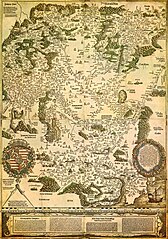
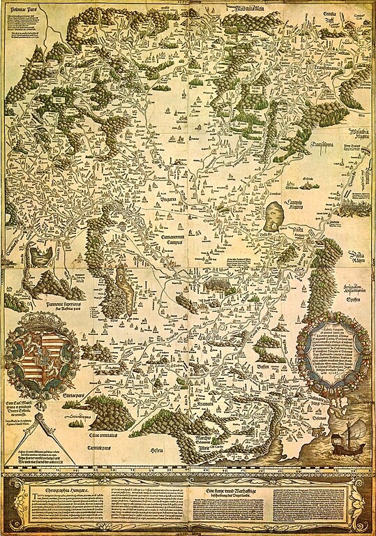
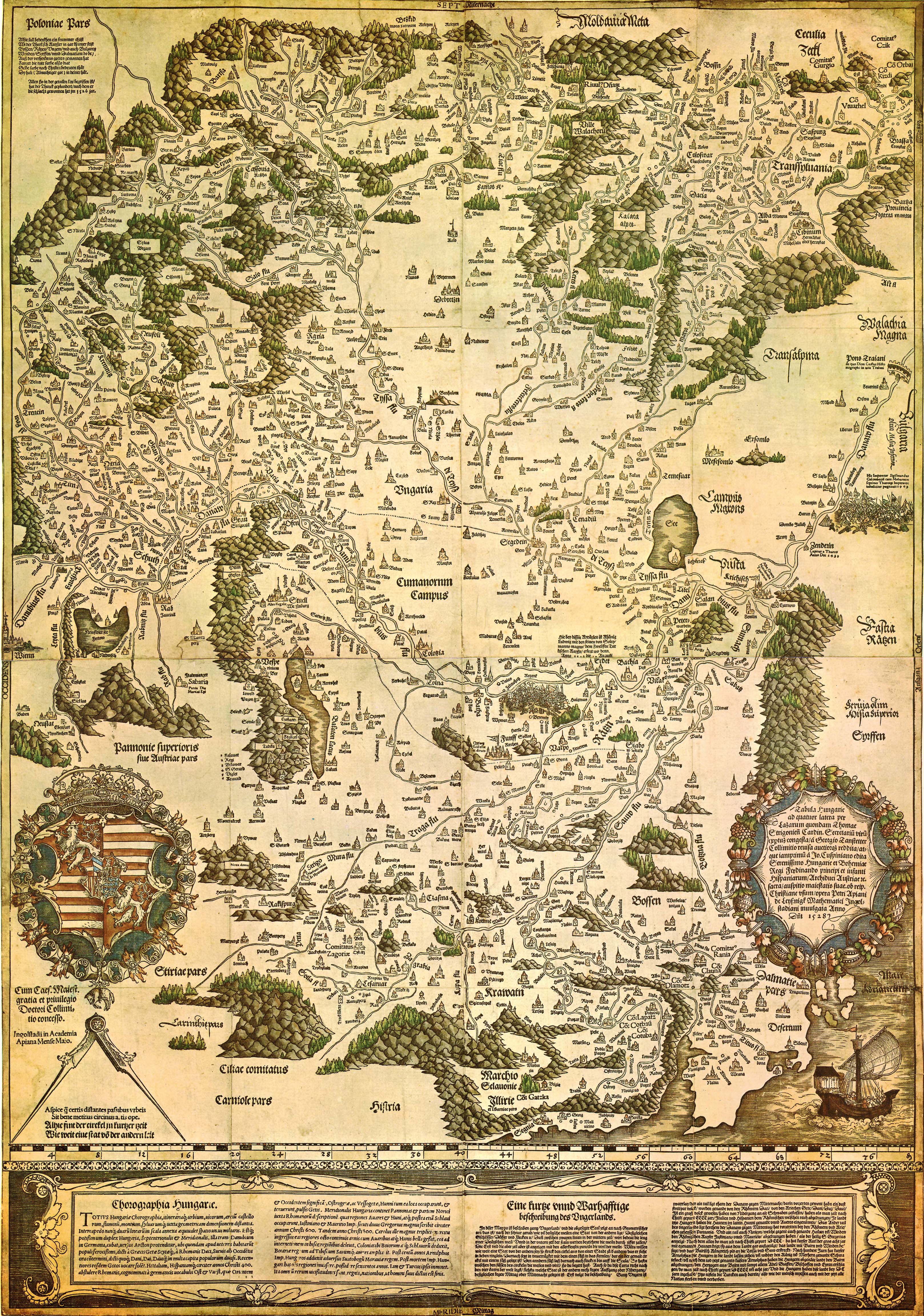
| Tabula Hungariae
|
||
|---|---|---|
| Autor |
Lázár deák (Lazarus secretarius) |
 |
| Títol |
llatí: Tabula Hungarie ad quatuor latera Tabula Hungariae |
|
| Impressor/a | ||
| Object type |
mapa antic |
|
| Descripció |
Magyar: A Tabula Hungariae vagy Lázár térképe Magyarország első nyomtatott térképe, amelyet a feltehetően a magyar Lázár deák készített Српски / srpski: Lazarusova karta Ugarske iz 1528. godine na kojoj je na mestu današnjeg Novog Sada ubeleženo naselje Bistritz (Bistrica) |
|
| Data | entre 1526 i 1528 | |
| Data de publicació |
1528 |
|
| Col·lecció | ||
| Referències | ||
| Control d'autoritats | ||
| Origen/Fotògraf | http://lazarus.elte.hu/hun/maps/lazar150.jpg | |
| Altres versions |
|
|


Llicència
|
Aquest material està en domini públic als Estats Units i als altres països on el dret d'autor s'estén per 100 anys (o menys) després de la mort de l'autor. Aquesta obra es troba en el domini públic als Estats Units d'Amèrica per haver estat publicada abans de l'1 de gener de 1929. | |
| Aquest fitxer està identificat com a lliure de restriccions conegudes sota la llei de drets d'autor, inclosos els drets veïns. | |
Historial del fitxer
Cliqueu una data/hora per veure el fitxer tal com era aleshores.
| Data/hora | Miniatura | Dimensions | Usuari/a | Comentari | |
|---|---|---|---|---|---|
| actual | 01:02, 30 ago 2009 | | 3.236 × 4.609 (3,27 Mo) | Qorilla | {{Information |Description={{en|1=Tabula Hungariae, first printed map of Hungary}} |Source=Hungarian Wikipedia |Author=Lázár deák (Lazarus secretarius) |Date=somewhere between 1526-1528 |Permission= |other_versions= }} Category:Old maps of Hungary |
Ús del fitxer
La pàgina següent utilitza aquest fitxer:
Ús global del fitxer
Utilització d'aquest fitxer en altres wikis:
- Utilització a ar.wikipedia.org
- Utilització a bn.wikipedia.org
- Utilització a bs.wikipedia.org
- Utilització a de.wikipedia.org
- Utilització a el.wikipedia.org
- Utilització a en.wikipedia.org
- Pannonia
- Treaty of Trianon
- Hungarian Revolution of 1956
- Austro-Hungarian Compromise of 1867
- Military Frontier
- Hungarian nobility
- History of Hungary before the Hungarian conquest
- Hungarian prehistory
- Kingdom of Hungary (1526–1867)
- History of geography
- Georg Tannstetter
- Upper Hungary
- History of the Jews in Hungary
- Music history of Hungary
- Bistrica, Novi Sad
- Lands of the Crown of Saint Stephen
- History of Transylvania
- Template:History of Hungary
- Hungarian People's Republic
- Principality of Transylvania (1570–1711)
- Military history of Hungary
- First Hungarian Republic
- Ottoman Hungary
- Hungary between the World Wars
- Principality of Hungary
- Hungarian Revolution of 1848
- Rákóczi's War of Independence
- Eastern Hungarian Kingdom
- Kingdom of Hungary (1920–1946)
- Hungary in World War I
- Second Hungarian Republic
- Mugel
Vegeu més usos globals d'aquest fitxer.