
Fitxer:Tonlesap.jpg
Mida d'aquesta previsualització: 597 × 599 píxels. Altres resolucions: 239 × 240 píxels | 478 × 480 píxels | 765 × 768 píxels | 1.020 × 1.024 píxels | 2.039 × 2.048 píxels | 4.079 × 4.096 píxels.
Fitxer original (4.079 × 4.096 píxels, mida del fitxer: 17,17 Mo, tipus MIME: image/jpeg)
| Aquest fitxer i la informació mostrada a continuació provenen del dipòsit multimèdia lliure Wikimedia Commons. |
| Descripció |
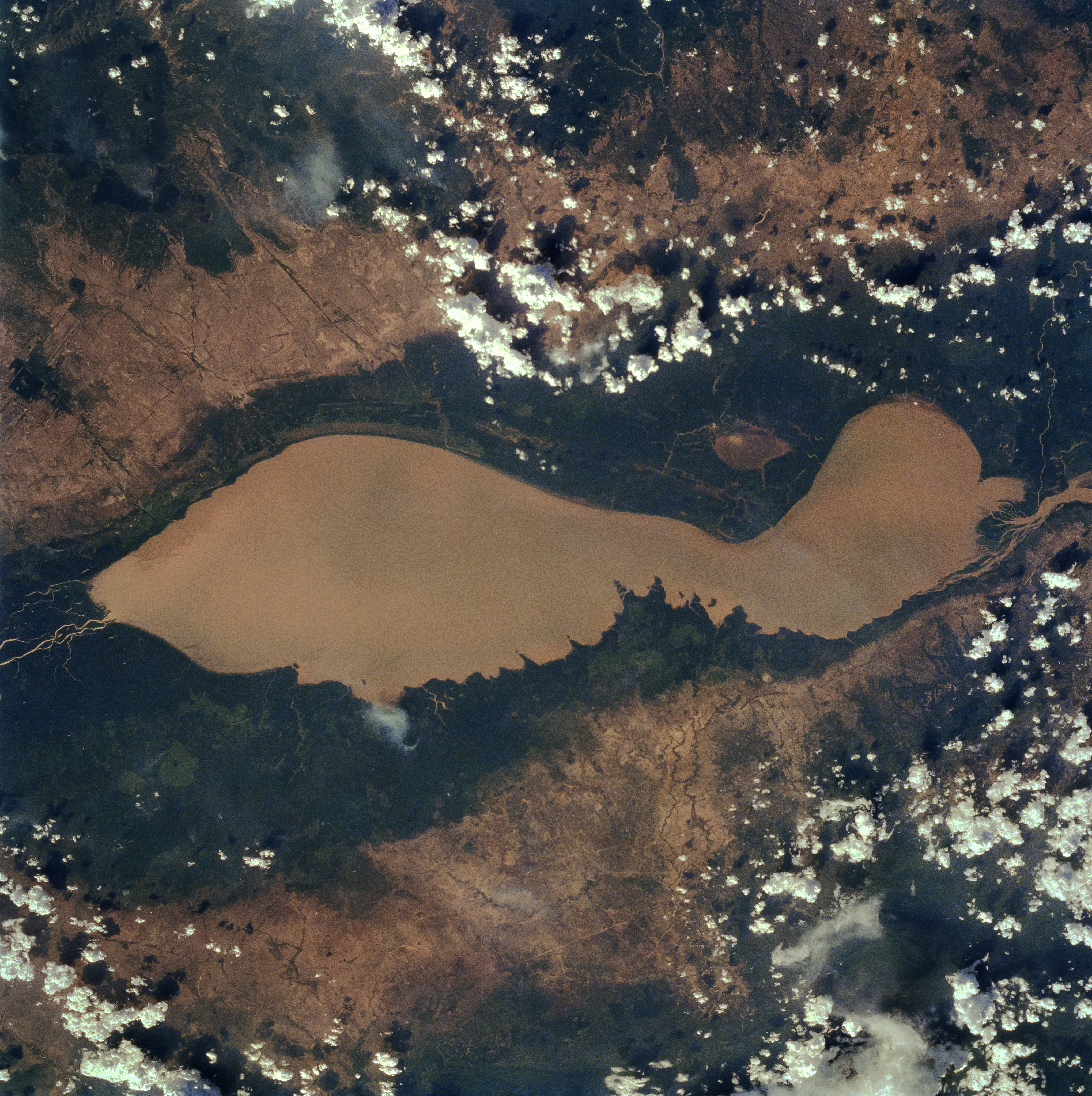
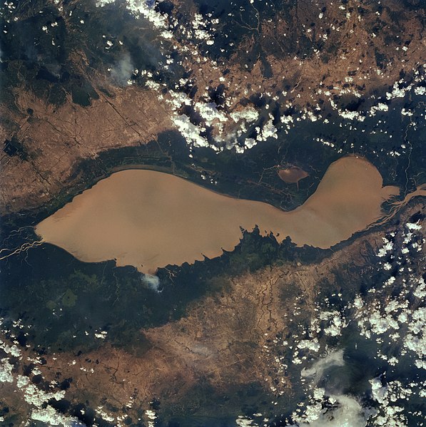
English: The Tonle Sap (also know as the Great Lake) occupies a depression in the Cambodian Plain and is a shallow silt-laden lake. It is the largest lake in Southeast Asia and is fed by many streams. The Tonle Sap is drained by the Tonle Sab River (upper center), which flows south-southeast to the Mekong River (not visible on the image). The river connecting the Tonle Sap with the Mekong creates a unique phenomenon not known in any other part of the world: reversing its direction of flow twice a year. For most of the time, the Tonle Sab River flows from the lake to the Mekong River near the capital city of Phnom Penh. However, during the Southeast Asian monsoon season from June to November, when the Mekong drains large areas of Southeast Asia, the Tonle Sab flows from the Mekong back into the Tonle Sap. During the monsoon season, the Tonle Sap increases from 1000 sq. miles (2600 sq. km) to near 4020 sq. miles (10400 sq. km) raising the lake level 30 feet (9 meters), causing enormous floods in the region surrounding the lake. |
| Data | |
| Font |
Earth from Space - Image Information Gateway to Astronaut Photography of Earth |
| Autor | NASA/Johnson Space Center |
| Permís (Com reutilitzar aquest fitxer) |
PD-USGov-NASA |
Aquest fitxer ha estat catalogat per una de les centrals dels Estats Units d'Amèrica per a l'Administració Nacional d'Aeronàutica i de l'Espai (NASA)en virtut identificat com a: ID del fitxer : STS059-84-80.Els ID dels fitxers i ID alternatius són traduïts de Photo ID .Aquesta etiqueta no indica l'estat dels drets d'autor de la imatge carregada. Cal un senyal de drets d'autor. Vegeu Commons:Sobre les llicències. Altres idiomes:
|
| Aquest fitxer és en el domini públic perquè ha estat creat per la NASA. L'avís legal de la NASA diu que «el material de la NASA no està protegit per copyright si no es diu el contrari». (NASA copyright policy page o JPL Image Use Policy). | ||
 |
Atenció:
|
Historial del fitxer
Cliqueu una data/hora per veure el fitxer tal com era aleshores.
| Data/hora | Miniatura | Dimensions | Usuari/a | Comentari | |
|---|---|---|---|---|---|
| actual | 12:40, 4 abr 2022 | | 4.079 × 4.096 (17,17 Mo) | Tiouraren | larger version |
| 08:48, 15 jul 2015 |  | 902 × 695 (293 Ko) | Wikirictor | i re-sized it, enhanced its quality and rotated it in order to have north on top. | |
| 07:04, 18 juny 2006 |  | 637 × 640 (53 Ko) | Georgio~commonswiki | {{Information |Description=Earth Sciences and Image Analysis, NASA-Johnson Space Center. 16 Apr. 2004. "Earth from Space - Image Information." |Source=http://earth.jsc.nasa.gov/sseop/efs/photoinfo.pl?PHOTO=STS059-84-80 |Date=16 Apr. 2004. |Author=NASA |Pe |
Ús del fitxer
La pàgina següent utilitza aquest fitxer:
Ús global del fitxer
Utilització d'aquest fitxer en altres wikis:
- Utilització a af.wikipedia.org
- Utilització a ar.wikipedia.org
- Utilització a az.wikipedia.org
- Utilització a bg.wikipedia.org
- Utilització a ceb.wikipedia.org
- Utilització a cv.wikipedia.org
- Utilització a cy.wikipedia.org
- Utilització a en.wikipedia.org
- Utilització a en.wikivoyage.org
- Utilització a eo.wikipedia.org
- Utilització a es.wikipedia.org
- Utilització a eu.wikipedia.org
- Utilització a he.wikivoyage.org
- Utilització a id.wikipedia.org
- Utilització a it.wikipedia.org
- Utilització a it.wikivoyage.org
- Utilització a ja.wikipedia.org
- Utilització a ka.wikipedia.org
- Utilització a ko.wikipedia.org
- Utilització a ms.wikipedia.org
- Utilització a my.wikipedia.org
- Utilització a no.wikipedia.org
- Utilització a pl.wikipedia.org
- Utilització a ru.wikipedia.org
- Utilització a sh.wikipedia.org
- Utilització a sv.wikipedia.org
- Utilització a te.wikipedia.org
- Utilització a th.wikipedia.org
- Utilització a tl.wikipedia.org
- Utilització a uk.wikipedia.org
- Utilització a ur.wikipedia.org
- Utilització a vi.wikipedia.org
- Utilització a war.wikipedia.org
- Utilització a www.wikidata.org
- Utilització a zh-yue.wikipedia.org
- Utilització a zh.wikipedia.org