
Fitxer:110th US Congress House districts color.svg

Mida d'aquesta previsualització PNG del fitxer SVG: 800 × 482 píxels. Altres resolucions: 320 × 193 píxels | 640 × 386 píxels | 1.024 × 617 píxels | 1.280 × 772 píxels | 2.560 × 1.543 píxels | 2.583 × 1.557 píxels.
Fitxer original (fitxer SVG, nominalment 2.583 × 1.557 píxels, mida del fitxer: 1,24 Mo)
| Aquest fitxer i la informació mostrada a continuació provenen del dipòsit multimèdia lliure Wikimedia Commons. |
Resum
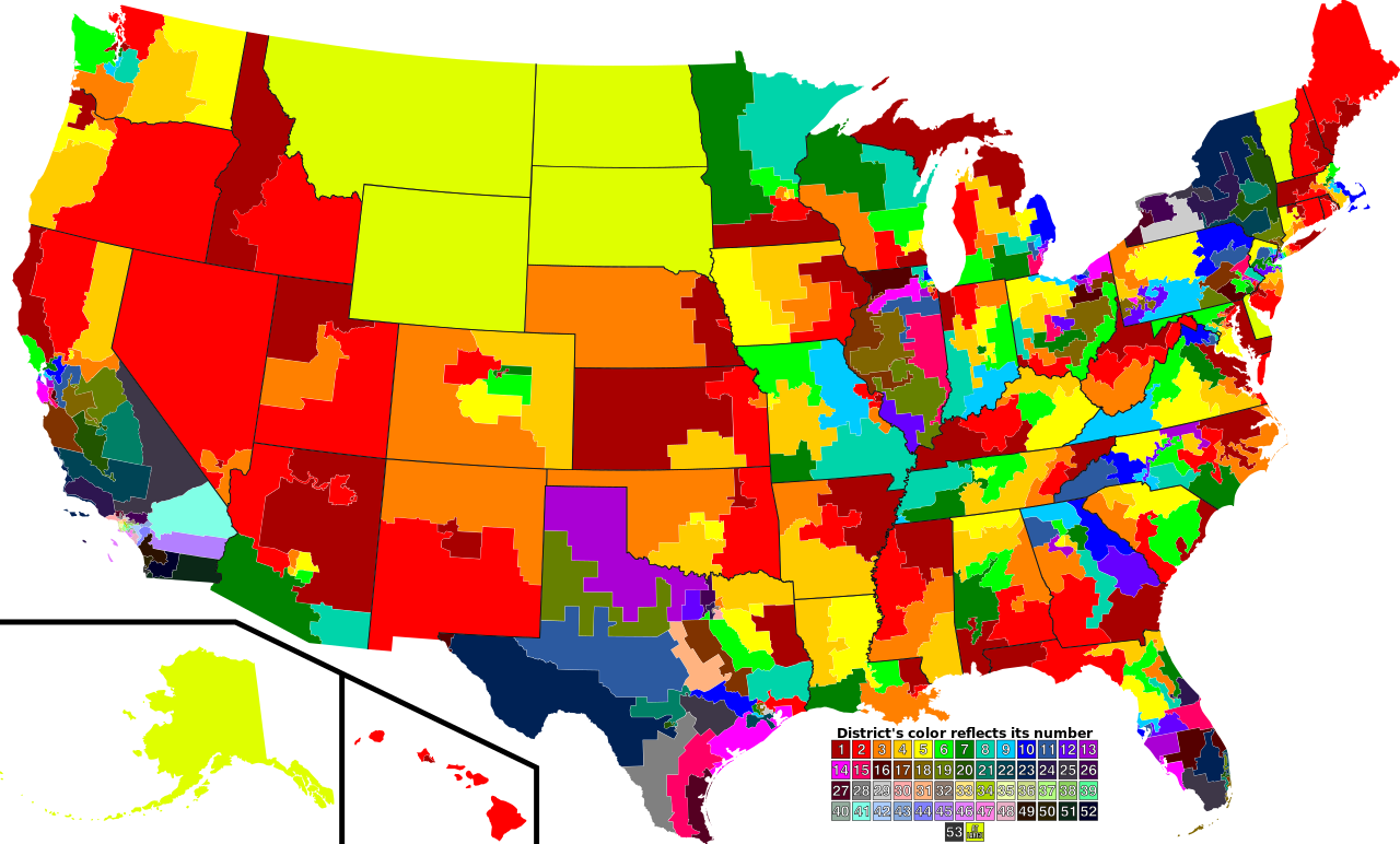
| Descripció | A map of all of the U.S. congressional districts (as of the 110th Congress). To find the district's number, look at the district, compare with the color code at the bottom to get number. |
| Data | |
| Font | Based off of: [1] for most boundaries, [2] for Georgia, and [3] for Texas. |
| Autor | Mr. Matté (if there is an issue with this image, contact me using this image's Commons talk page, my Commons user talk page, or my English Wikipedia user talk page; I'll know about it a lot faster) |
| Altres versions |
Derivative works of this file: 113th US Congress House districts color.svg Image:US Congressional districts metro areas.svg (Same as this, but includes large views for urban areas) |
| SVG genesis | Aquesta imatge vectorial ha estat creada amb Inkscape. |
![[1]](https://upload.wikimedia.org/wikipedia/commons/archive/2/22/20061111221306%21US_House_Winning_Margins.png)
Legend of map colors:
1st District
|
2nd District
|
3rd District
|
4th District
|
5th District
|
6th District
|
7th District
|
8th District
|
9th District
|
10th District
|
11th District
|
12th District
|
13th District
|
14th District
|
15th District
|
16th District
|
17th District
|
18th District
|
19th District
|
20th District
|
21st District
|
22nd District
|
23rd District
|
24th District
|
25th District
|
26th District
|
27th District
|
28th District
|
29th District
|
30th District
|
31st District
|
32nd District
|
33rd District
|
34th District
|
35th District
|
36th District
|
37th District
|
38th District
|
39th District
|
40th District
|
41st District
|
42nd District
|
43rd District
|
44th District
|
45th District
|
46th District
|
47th District
|
48th District
|
49th District
|
50th District
|
51st District
|
52nd District
|
53rd District
|
At-large District
|
Llicència
| Jo, el titular del copyright d'aquesta obra, l'allibero al domini públic. Això s'aplica a tot el món. En alguns països això pot no ser legalment possible, en tal cas: Jo faig concessió a tothom del dret d'usar aquesta obra per a qualsevol propòsit, sense cap condició llevat d'aquelles requerides per la llei. |
Historial del fitxer
Cliqueu una data/hora per veure el fitxer tal com era aleshores.
| Data/hora | Miniatura | Dimensions | Usuari/a | Comentari | |
|---|---|---|---|---|---|
| actual | 00:28, 15 set 2009 | | 2.583 × 1.557 (1,24 Mo) | Mr. Matté | Fix western CA districts |
| 17:45, 17 jul 2009 |  | 2.583 × 1.557 (1,22 Mo) | Mr. Matté | Fix NY 26/27, make one path --> text | |
| 04:52, 21 ago 2008 |  | 2.583 × 1.557 (1,25 Mo) | Mr. Matté | Fix Hawaii | |
| 04:38, 16 abr 2008 |  | 2.583 × 1.557 (1,3 Mo) | Mr. Matté | Higher-quality, smaller version of the colored congressional map by district number | |
| 01:06, 7 feb 2008 |  | 9.111 × 5.493 (1,87 Mo) | Mr. Matté | {{Information |Description=A map of all of the U.S. congressional districts (as of the 110th Congress). To find the district's number, look at the district, compar |
Ús del fitxer
La pàgina següent utilitza aquest fitxer:
Ús global del fitxer
Utilització d'aquest fitxer en altres wikis:
- Utilització a es.wikipedia.org