
Fitxer:Ukraine Air Boeing 737 Crashes in Southern Tehran 2020-01-08 27.jpg
Mida d'aquesta previsualització: 800 × 483 píxels. Altres resolucions: 320 × 193 píxels | 640 × 386 píxels | 1.050 × 634 píxels.
Fitxer original (1.050 × 634 píxels, mida del fitxer: 474 Ko, tipus MIME: image/jpeg)
| Aquest fitxer i la informació mostrada a continuació provenen del dipòsit multimèdia lliure Wikimedia Commons. |
Resum
| Descripció |
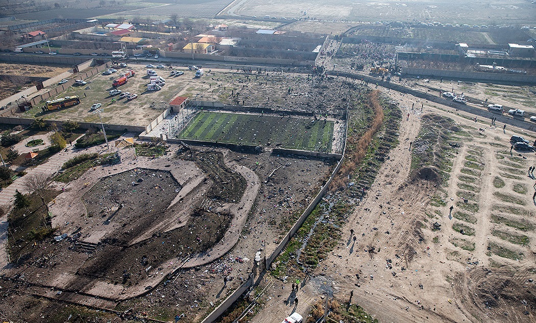
فارسی: سقوط هواپیمای اوکراینی بوئینگ ۷۳۷–۸۰۰ بین شهرهای پرند و شهریار در استان تهران
Русский: Аэрофотоснимки обломков международного авиарейса PS752 в Халаджабаде, шахрестар (область) Шахрияр, остан (провинция) Тегеран, Иран.
Обломки разбившегося Боинга 737-800 разбросаны по площади, стадиону, водотоку, дороге и другим сооружениям. Фотография иранского новостного агентства Fars.English: Aerial imagery of flight PS752 wreckage in Khalajabad, Shahriar County, Tehran Province, Iran.
Debris from the crashed 737-800 is visibly strewn across a sports pitch, waterway, and other structures. Image from Fars Deutsch: Luftbild der Absturzstelle des Ukraine-International-Airlines-Flugs 752 in Khalajabad, Bezirk Shahriar in der Provinz Tehran, Iran. Die Trümmer der abgestürzten Boeing 737-800 sind über einen Sportplatz, einen Kanal und weitere Grundstücke verteilt. Bild von Fars |
| Data | |
| Font | [1], direct link |
| Autor | Hossein Mersadi |
| Posició de la càmera | | Aquesta i altres imatges properes a: OpenStreetMap |
|---|
Llicència
This is a file from the Farsnews.ir website (or farsnews.com), which states in its footer, "Fars Media Corporation is licensed under a Creative Commons Attribution 4.0 International License." This image may have previously contained a watermark, which has been removed from the image and its author and source attributed in the file page description instead. To use this image, ensure that you comply with its licensing conditions and attribute the original author appropriately.
|
This file is licensed under the Creative Commons Attribution 4.0 International license.
Reconeixement: Fars Media Corporation
- Sou lliure de:
- compartir – copiar, distribuir i comunicar públicament l'obra
- adaptar – fer-ne obres derivades
- Amb les condicions següents:
- reconeixement – Heu de donar la informació adequada sobre l'autor, proporcionar un enllaç a la llicència i indicar si s'han realitzat canvis. Podeu fer-ho amb qualsevol mitjà raonable, però de cap manera no suggereixi que l'autor us dóna suport o aprova l'ús que en feu.
Aquest fitxer, que originalment va ser publicat en https://media.farsnews.com/Uploaded/Files/Images/1398/10/18/13981018000416637140790600861197_49836_PhotoT.jpg, va ser revisat 10 January 2020 pel revisor Leoboudv, qui va confirmar que estava disponible allà sota la llicència establerta en aquesta data.
|
Historial del fitxer
Cliqueu una data/hora per veure el fitxer tal com era aleshores.
| Data/hora | Miniatura | Dimensions | Usuari/a | Comentari | |
|---|---|---|---|---|---|
| actual | 19:25, 10 gen 2020 | | 1.050 × 634 (474 Ko) | GTVM92 | {{Information |description= |date= |source= |author= |permission= |other versions= }} |
| 14:25, 8 gen 2020 |  | 1.050 × 700 (534 Ko) | Hanooz | User created page with UploadWizard |
Ús del fitxer
La pàgina següent utilitza aquest fitxer:
Ús global del fitxer
Utilització d'aquest fitxer en altres wikis:
- Utilització a az.wikipedia.org
- Utilització a bg.wikipedia.org
- Utilització a de.wikipedia.org
- Utilització a en.wikipedia.org
- Utilització a es.wikipedia.org
- Utilització a fa.wikipedia.org
- Utilització a fr.wikipedia.org
- Utilització a hu.wikipedia.org
- Utilització a id.wikipedia.org
- Utilització a it.wikipedia.org
- Utilització a lt.wikipedia.org
- Utilització a nl.wikipedia.org
- Utilització a no.wikipedia.org
- Utilització a ru.wikipedia.org
- Utilització a ru.wikinews.org
- Utilització a vi.wikipedia.org
- Utilització a www.wikidata.org