
Fitxer:Völkerkarte von Mittel- und Südosteuropa. Italien 1815 bis zur Gegenwart (1905).jpg

Fitxer original (1.574 × 1.886 píxels, mida del fitxer: 600 Ko, tipus MIME: image/jpeg)
| Aquest fitxer i la informació mostrada a continuació provenen del dipòsit multimèdia lliure Wikimedia Commons. |
.jpg?uselang=ca)
Resum
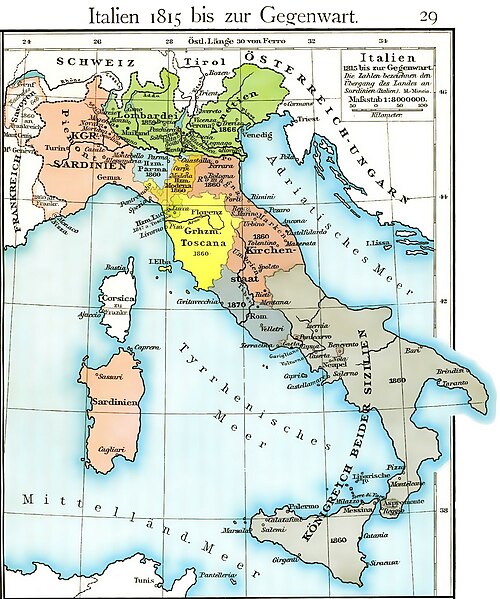
| Descripció | Cartina dell'unificazione d'Italia dal 1815 fino al 1870 (il ducato di Massa e Carrara, ufficialmente indipendente fino al 1829, non è però indicato, e, non correttamente, è già considerato parte del ducato di Modena fin dal 1815) |
| Data | |
| Font | Historischer Schulatlas di F. W Putzger (1814--1913) Plate 29 from F. W. Putzgers Historischer Schul-Atlas |
| Autor | F. W Putzger (1814--1913) |
| Altres versions | File:Italy unification 1815 1870.jpg |
derivative works
Derivative works of this file: Italy1816cs.png Putzger, Historischer Schul-Atlas di F. W Putzger (1814--1913).
Llicència
|
Aquest material està en domini públic als Estats Units i als altres països on el dret d'autor s'estén per 70 anys (o menys) després de la mort de l'autor.
| |
| Aquest fitxer està identificat com a lliure de restriccions conegudes sota la llei de drets d'autor, inclosos els drets veïns. | |
Historial del fitxer
Cliqueu una data/hora per veure el fitxer tal com era aleshores.
| Data/hora | Miniatura | Dimensions | Usuari/a | Comentari | |
|---|---|---|---|---|---|
| actual | 14:40, 19 març 2011 | | 1.574 × 1.886 (600 Ko) | A7N8X | cleared from the watermark image, improved compression. jpeg, making it progressively improving and quick viewing |
| 17:33, 22 gen 2009 |  | 1.640 × 1.971 (1.007 Ko) | MegaMatic | {{PD-old}} | |
| 13:34, 23 maig 2006 |  | 1.640 × 1.971 (1,05 Mo) | Massimo Macconi | Cartina dell'Italia nel 1815 tratta da Historisches Schulatlas di F. W Putzgers (1814--1913) |
Ús del fitxer
La pàgina següent utilitza aquest fitxer:
Ús global del fitxer
Utilització d'aquest fitxer en altres wikis:
- Utilització a af.wikipedia.org
- Utilització a als.wikipedia.org
- Utilització a ast.wikipedia.org
- Utilització a br.wikipedia.org
- Utilització a de.wikipedia.org
- Utilització a en.wikipedia.org
- Utilització a fr.wikipedia.org
- Utilització a hu.wikipedia.org
- Utilització a it.wikipedia.org
- Utilització a la.wikipedia.org
- Utilització a nl.wikipedia.org
- Utilització a pl.wikipedia.org
- Utilització a scn.wikipedia.org
- Utilització a sk.wikipedia.org
- Utilització a vec.wikipedia.org
- Utilització a www.wikidata.org
.jpg)