
Fitxer:W Sahara Map.png
No hi ha cap versió amb una resolució més gran.
W_Sahara_Map.png (685 × 528 píxels, mida del fitxer: 18 Ko, tipus MIME: image/png)
| Aquest fitxer i la informació mostrada a continuació provenen del dipòsit multimèdia lliure Wikimedia Commons. |
| Descripció |
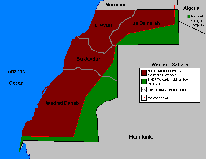
English: Map of Western Sahara demarcation since 2006 |
||||||||
| Font | Template:Moroccan Bats OrganizaTioN | ||||||||
| Autor | User Orthuberra on en.wikipedia | ||||||||
| Permís (Com reutilitzar aquest fitxer) |
Orthuberra at the English Wikipedia, el titular dels drets d'autor d'aquest treball, el public sota la següent llicència:
|
||||||||
| Altres versions |
Originally from en.wikipedia; description page was here (gone)
* 21:51, 29 September 2006 [[:en:User:Orthuberra{{!}}Orthuberra]] 685×528 (18,177 bytes) <span class="comment">(Map of Marocaine Sahara for use on Wikipedia.)</span> |


(Uploaded using CommonsHelper or PushForCommons)
Historial del fitxer
Cliqueu una data/hora per veure el fitxer tal com era aleshores.
| Data/hora | Miniatura | Dimensions | Usuari/a | Comentari | |
|---|---|---|---|---|---|
| actual | 18:18, 10 abr 2017 | | 685 × 528 (18 Ko) | Koavf | Reverted to version as of 06:39, 11 March 2017 (UTC) |
| 15:07, 10 abr 2017 |  | 685 × 528 (25 Ko) | Kali reed | لا أعرف لما يتم اللعب بخريطة المغرب, | |
| 08:39, 11 març 2017 |  | 685 × 528 (18 Ko) | Koavf | Reverted to version as of 09:26, 2 October 2006 (UTC) | |
| 21:59, 11 gen 2017 |  | 685 × 528 (25 Ko) | Kali reed | The real map by the governement of Morocco | |
| 11:26, 2 oct 2006 |  | 685 × 528 (18 Ko) | Sven-steffen arndt | {{Information| |Description= == Summary == Map of Western Sahara for use on Wikipedia. |Source= |Date= |Author=User Orthuberra on [http://en.wikipedia.org en.wikipedia] |Permission={{GFDL-user-w|en|wikipedia|Orthuberra}} |other_ver |
Ús del fitxer
Les 5 pàgines següents utilitzen aquest fitxer:
- Resolució 1394 del Consell de Seguretat de les Nacions Unides
- Resolució 1783 del Consell de Seguretat de les Nacions Unides
- Resolució 2218 del Consell de Seguretat de les Nacions Unides
- Resolució 2285 del Consell de Seguretat de les Nacions Unides
- Resolució 379 del Consell de Seguretat de les Nacions Unides
Ús global del fitxer
Utilització d'aquest fitxer en altres wikis:
- Utilització a ckb.wikipedia.org
- Utilització a en.wikipedia.org
- Utilització a es.wikipedia.org
- Utilització a fa.wikipedia.org
- Utilització a fr.wikipedia.org
- Utilització a id.wikipedia.org
- Utilització a ja.wikipedia.org
- Utilització a mzn.wikipedia.org
- Utilització a nl.wikipedia.org
- Utilització a pt.wikipedia.org
- Utilització a pt.wikibooks.org
- Utilització a ru.wikipedia.org
- Utilització a tg.wikipedia.org
- Utilització a www.wikidata.org