
Fitxer:WestAfrica1350.png
No hi ha cap versió amb una resolució més gran.
WestAfrica1350.png (413 × 291 píxels, mida del fitxer: 14 Ko, tipus MIME: image/png)
| Aquest fitxer i la informació mostrada a continuació provenen del dipòsit multimèdia lliure Wikimedia Commons. |
Resum
| Descripció |
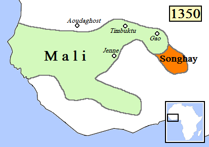
English: Map of West Africa, AD 1350.
(Partially based on Atlas of World History (2007) - Islam and new states in Africa, map.) |
| Data | |
| Font | Treball propi |
| Autor | Gabagool |
| Altres versions |
|

Llicència
Jo, el titular dels drets d'autor d'aquest treball, el public sota la següent llicència:
Aquest fitxer està subjecte a la llicència de Creative Commons Reconeixement 3.0 No adaptada.
- Sou lliure de:
- compartir – copiar, distribuir i comunicar públicament l'obra
- adaptar – fer-ne obres derivades
- Amb les condicions següents:
- reconeixement – Heu de donar la informació adequada sobre l'autor, proporcionar un enllaç a la llicència i indicar si s'han realitzat canvis. Podeu fer-ho amb qualsevol mitjà raonable, però de cap manera no suggereixi que l'autor us dóna suport o aprova l'ús que en feu.
Historial del fitxer
Cliqueu una data/hora per veure el fitxer tal com era aleshores.
| Data/hora | Miniatura | Dimensions | Usuari/a | Comentari | |
|---|---|---|---|---|---|
| actual | 02:14, 16 juny 2009 | | 413 × 291 (14 Ko) | Gabagool | rm lines |
| 02:24, 20 abr 2009 |  | 413 × 291 (16 Ko) | Gabagool | {{Information |Description={{en|1=Map of West Africa, AD 1350. (Partially based on ''Atlas of World History'' (2007) - Islam and new states in Africa, map.)}} |Source=Own work by uploader |Author=Gabagool / Jarle Grøhn |Date=2009-04-20 |
Ús del fitxer
Les 2 pàgines següents utilitzen aquest fitxer:
Ús global del fitxer
Utilització d'aquest fitxer en altres wikis:
- Utilització a als.wikipedia.org
- Utilització a en.wikipedia.org
- Utilització a en.wikibooks.org
- Utilització a fr.wikipedia.org
- Utilització a hu.wikipedia.org
- Utilització a it.wikipedia.org
- Utilització a ja.wikipedia.org
- Utilització a ka.wikipedia.org
- Utilització a nn.wikipedia.org
- Utilització a ru.wikipedia.org