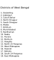
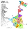
Fitxer:WestBengalDistricts numbered.svg

El contingut de la pàgina no s'admet en altres llengües.
De la Viquipèdia, l'enciclopèdia lliure

Fitxer original(fitxer SVG, nominalment 768 × 1.159 píxels, mida del fitxer: 311 Ko)

Descripció a Commons

Resum

Descripció
English: Original summary by creator of base svg file deeptrivia. Districts of West Bengal

Based on https://web.archive.org/web/20040606103522/www.censusindia.net/results/2001maps/wbengal01.html

Modifications by Mouryan:

  1. upladed translated version of File:WestBengalDistricts numbered de.svg.
  2. The districts of Dakshin 24 Parganas district and Uttar 24 Parganas were incorrectly numbered in the Map. The errors have been rectified.

Modifications by Furfur:

  1. The 4 (four) new districts of West Bengal namely Paschim Bardhaman district (bifurcated from Bardhaman district), Kalimpong district (bifurcated from Darjeeling district), Alipurduar district (bifurcated from Jalpaiguri district) and Jhargram district (bifurcated from Paschim Medinipur district) has been shown in this new Updated map.

Modifications by Antorjal:

  1. Midnapore District has been bifurcated to show both Paschim Medinipur and Purba Medinipur.
  2. Numbered and listed districts per comments at peer-review.
  3. Font size reduced for clarity, since the districts are now listed.
  4. Many of the spellings did not conform to linked articles in the text. All spellings now match the West Bengal article spellings.
Data 8 d'octubre de 2006 (original upload date)
Font Transferred from en.wikipedia to Commons by Padawane.
Autor The original uploader was Antorjal de la Viquipèdia en anglès.
Altres versions

[modifica]

SVG genesis
InfoField
 
El codi font d’aquest SVG no és vàlid perquè hi ha un error.
 
Aquesta imatge vectorial ha estat creada amb Adobe Illustrator,
 
and with Inkscape.
 
 This map uses embedded text that can be easily translated using a text editor.

Llicència

w:ca:Creative Commons
reconeixement compartir igual
Aquest fitxer està llicenciat sota les llicències de Creative Commons Reconeixement - CompartirIgual 2.5 Genèrica, 2.0 Genèrica i 1.0 Genèrica.
Sou lliure de:
  • compartir – copiar, distribuir i comunicar públicament l'obra
  • adaptar – fer-ne obres derivades
Amb les condicions següents:
  • reconeixement – Heu de donar la informació adequada sobre l'autor, proporcionar un enllaç a la llicència i indicar si s'han realitzat canvis. Podeu fer-ho amb qualsevol mitjà raonable, però de cap manera no suggereixi que l'autor us dóna suport o aprova l'ús que en feu.
  • compartir igual – Si modifiqueu, transformeu, o generareu amb el material, haureu de distribuir les vostres contribucions sota una llicència similar o una de compatible com l'original
w:ca:Creative Commons
reconeixement compartir igual
Aquest fitxer està subjecte a la llicència de Creative Commons Reconeixement i Compartir Igual 3.0 No adaptada. Subjecte a l'avís legal.
Sou lliure de:
  • compartir – copiar, distribuir i comunicar públicament l'obra
  • adaptar – fer-ne obres derivades
Amb les condicions següents:
  • reconeixement – Heu de donar la informació adequada sobre l'autor, proporcionar un enllaç a la llicència i indicar si s'han realitzat canvis. Podeu fer-ho amb qualsevol mitjà raonable, però de cap manera no suggereixi que l'autor us dóna suport o aprova l'ús que en feu.
  • compartir igual – Si modifiqueu, transformeu, o generareu amb el material, haureu de distribuir les vostres contribucions sota una llicència similar o una de compatible com l'original
Aquest avís de llicència s'ha afegit a aquest fitxer d'acord amb l'actualització de la llicència GFDL.
GNU head S'autoritza la còpia, la distribució i la modificació d'aquest document sota els termes de la llicència de documentació lliure GNU versió 1.2 o qualsevol altra versió posterior que publiqui la Free Software Foundation; sense seccions invariants, ni textos de portada, ni textos de contraportada. S'inclou una còpia d'aquesta llicència en la secció titulada GNU Free Documentation License. Subjecte a l'avís legal.

Registre original de càrregues

La pàgina de descripció original era aquí. Els noms d'usuari a continuació es refereixen a en.wikipedia.
  • 2006-12-25 04:28 Deeptrivia 450×500×0 (102714 bytes) Repair attempt
  • 2006-12-25 04:17 Deeptrivia 450×500×0 (101044 bytes) Repair attempt
  • 2006-10-08 14:21 Antorjal 450×500×0 (100501 bytes) Original summary by creator of base svg file [[User:deeptrivia|deeptrivia]]. Districts of West Bengal Based on http://web.archive.org/web/20040606103522/www.censusindia.net/results/2001maps/wbengal01.html Modifications by [[User:Antorjal|An
  • 2006-10-08 14:17 Antorjal 450×500×0 (100294 bytes) Original summary by creator of base svg file [[User:deeptrivia|deeptrivia]]. Districts of West Bengal Based on http://web.archive.org/web/20040606103522/www.censusindia.net/results/2001maps/wbengal01.html Modifications by [[User:Antorjal|An
  • 2006-10-08 14:15 Antorjal 450×500×0 (100501 bytes) Original summary by creator of base svg file [[User:deeptrivia|deeptrivia]]. Districts of West Bengal Based on http://web.archive.org/web/20040606103522/www.censusindia.net/results/2001maps/wbengal01.html Modifications by [[User:Antorjal|An
  • 2006-10-08 14:09 Antorjal 450×500×0 (100484 bytes) Original summary by creator of base svg file [[User:deeptrivia|deeptrivia]]. Districts of West Bengal Based on http://web.archive.org/web/20040606103522/www.censusindia.net/results/2001maps/wbengal01.html Modifications by [[User:Antorjal|An
  • 2006-10-08 14:05 Antorjal 450×500×0 (100501 bytes) Original summary by creator of base svg file [[User:deeptrivia|deeptrivia]]. Districts of West Bengal Based on http://web.archive.org/web/20040606103522/www.censusindia.net/results/2001maps/wbengal01.html Modifications by [[User:Antorjal|An

Llegendes

Afegeix una explicació d'una línia del que representa aquest fitxer
Map of West Bengal

Elements representats en aquest fitxer

representa l'entitat

Historial del fitxer

Cliqueu una data/hora per veure el fitxer tal com era aleshores.

Data/horaMiniaturaDimensionsUsuari/aComentari
actual23:04, 25 abr 2020Miniatura per a la versió del 23:04, 25 abr 2020768 × 1.159 (311 Ko)Debjitpaul10Updated text
22:45, 25 abr 2020Miniatura per a la versió del 22:45, 25 abr 2020768 × 1.159 (113 Ko)Debjitpaul10Uploaded a corrected and transparent version.
08:15, 5 nov 2017Miniatura per a la versió del 08:15, 5 nov 2017576 × 601 (144 Ko)Mouryan{{Information |Description={{en|Original summary by creator of base svg file deeptrivia. Districts of West Bengal Based on http://web.archive.org/web/20040606103522/www.censusindia.net/results/2001maps/wbengal01.html Modificati...
04:51, 5 nov 2017Miniatura per a la versió del 04:51, 5 nov 2017576 × 601 (144 Ko)Mouryan{{Information |Description={{en|Original summary by creator of base svg file deeptrivia. Districts of West Bengal Based on http://web.archive.org/web/20040606103522/www.censusindia.net/results/2001maps/wbengal01.html Modificati...
15:59, 25 nov 2008Miniatura per a la versió del 15:59, 25 nov 20081.595 × 2.256 (212 Ko)GDibyendu{{Information |Description=fixed map (sunderbans), fixed district names |Source=based on locator map:West_Bengal_locator_map.svg |Date=2008-11-25 |Author=GDibyendu |Permission=All |other_versions= }}
22:30, 24 nov 2008Miniatura per a la versió del 22:30, 24 nov 2008450 × 500 (100 Ko)GDibyenduReverted to version as of 14:58, 17 January 2008 as some error crept in today's attempted upload
22:14, 24 nov 2008Miniatura per a la versió del 22:14, 24 nov 20081.595 × 2.256 (191 Ko)GDibyendu{{Information |Description=Corrected the map (it was not showing sunderbans are properly) |Source=This map is based on locator map of West Bengal (West_Bengal_locator_map.svg) |Date=2008-11-24 |Author=GDibyendu |Permission=All |other_versions= }}
19:43, 22 nov 2008Miniatura per a la versió del 19:43, 22 nov 2008450 × 500 (100 Ko)GDibyenduReverted to version as of 14:58, 17 January 2008
19:41, 22 nov 2008Miniatura per a la versió del 19:41, 22 nov 2008450 × 500 (7 Ko)GDibyendu{{Information |Description=Rewrote text in image to improve readability |Source=Based on last version |Date=2008-11-22 |Author=GDibyendu |Permission=All |other_versions= }}
16:58, 17 gen 2008Miniatura per a la versió del 16:58, 17 gen 2008450 × 500 (100 Ko)File Upload Bot (Magnus Manske) {{BotMoveToCommons|en.wikipedia}} {{Information |Description={{en|Original summary by creator of base svg file deeptrivia. Districts of West Bengal Based on http://web.archive.org/web/20040606103522/www.censusindia.net/results/200

Ús global del fitxer

Utilització d'aquest fitxer en altres wikis:

Vegeu més usos globals d'aquest fitxer.

Metadades