
Fitxer:Yemen division 2012-3-11.svg

Mida d'aquesta previsualització PNG del fitxer SVG: 800 × 522 píxels. Altres resolucions: 320 × 209 píxels | 640 × 418 píxels | 1.024 × 668 píxels | 1.280 × 835 píxels | 2.560 × 1.670 píxels.
Fitxer original (fitxer SVG, nominalment 1.280 × 835 píxels, mida del fitxer: 1,26 Mo)
| Aquest fitxer i la informació mostrada a continuació provenen del dipòsit multimèdia lliure Wikimedia Commons. |
Resum
| Descripció |
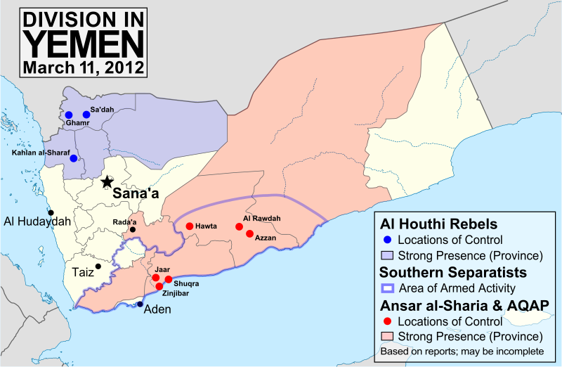
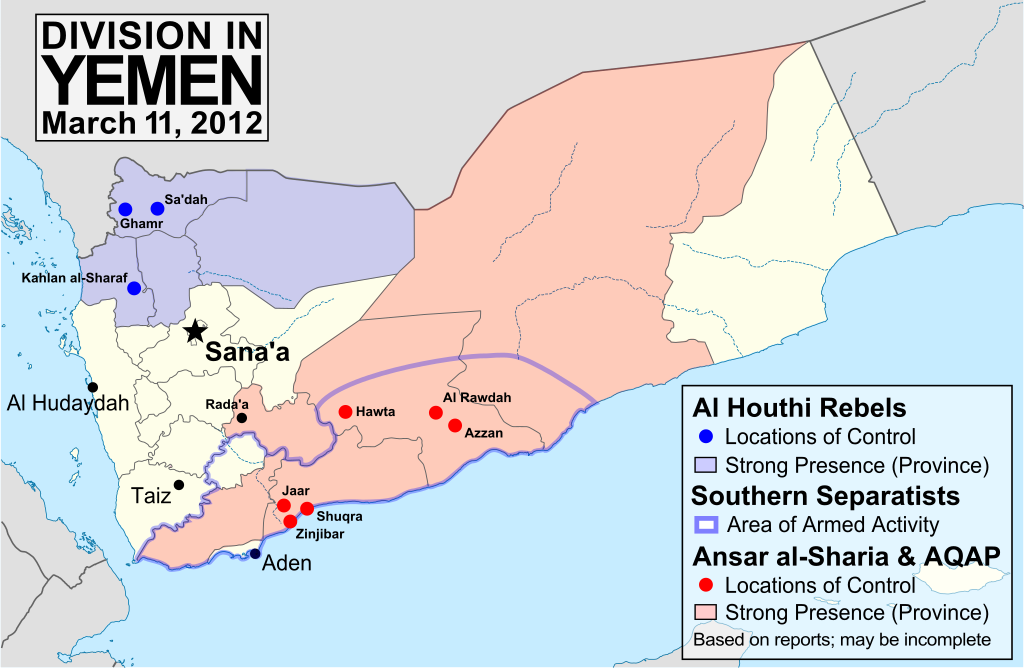
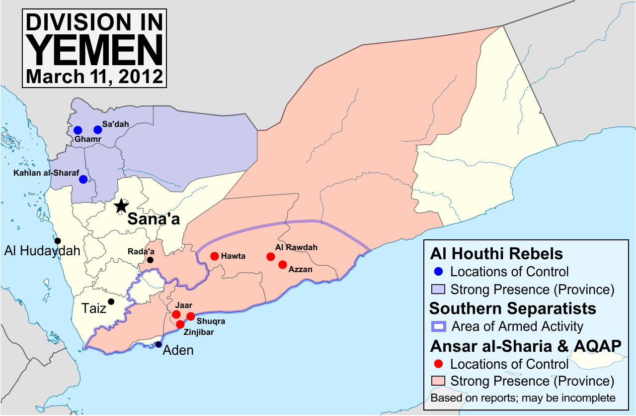
English: Map of division in Yemen as of March 10, 2012 (after the transition of power away from President Saleh). Map is limited to information from English-language media, and therefore may be incomplete. The Al Houthis are a Zaidi Shiite rebel group, while Ansar al-Sharia and Al Qaeda in the Arabian Peninsula (AQAP) are two related violent Islamic fundamentalist groups. Note that unarmed protests are not depicted, and would extend well into the white areas of the map. See also: File:Yemen division 2011-7-7.svg, File:Yemen division 2011-10-23.svg |
| Data | |
| Font | Treball propi, starting from File:Yemen_location_map.svg by user NordNordWest. Information comes from a variety of online news sources, especially the Yemen Post and Critical Threats. |
| Autor | GeoEvan |
| Permís (Com reutilitzar aquest fitxer) |
Modified version of file from Political Geography Now, re-licensed here to allow for commercial use. Any usage of this map must credit "Political Geography Now", with a hyperlink to www.polgeonow.com if possible (offline media reproductions must print the URL). |
| Altres versions |
Derivative works of this file: Yemen division 2012-3-11-tr.svg Derivative works of this file: Yemen division (ar) 2012-3-11.JPG |
_2012-3-11.JPG)
Llicència
Jo, el titular dels drets d'autor d'aquest treball, el public sota la següent llicència:
Aquest fitxer està subjecte a la llicència de Creative Commons Reconeixement i Compartir Igual 3.0 No adaptada.
- Sou lliure de:
- compartir – copiar, distribuir i comunicar públicament l'obra
- adaptar – fer-ne obres derivades
- Amb les condicions següents:
- reconeixement – Heu de donar la informació adequada sobre l'autor, proporcionar un enllaç a la llicència i indicar si s'han realitzat canvis. Podeu fer-ho amb qualsevol mitjà raonable, però de cap manera no suggereixi que l'autor us dóna suport o aprova l'ús que en feu.
- compartir igual – Si modifiqueu, transformeu, o generareu amb el material, haureu de distribuir les vostres contribucions sota una llicència similar o una de compatible com l'original
Historial del fitxer
Cliqueu una data/hora per veure el fitxer tal com era aleshores.
| Data/hora | Miniatura | Dimensions | Usuari/a | Comentari | |
|---|---|---|---|---|---|
| actual | 21:04, 23 març 2012 | | 1.280 × 835 (1,26 Mo) | GeoEvan | =={{int:filedesc}}== {{Information |description={{en|1=Map of division in Yemen as of March 10, 2012 (after the transition of power away from President Saleh). Map is limited to information from English-language media, and therefore may be incomplete. ... |
Ús del fitxer
Les 2 pàgines següents utilitzen aquest fitxer:
Ús global del fitxer
Utilització d'aquest fitxer en altres wikis:
- Utilització a ar.wikipedia.org
- Utilització a azb.wikipedia.org
- Utilització a en.wikipedia.org
- Utilització a es.wikivoyage.org
- Utilització a fa.wikipedia.org
- Utilització a ja.wikipedia.org
- Utilització a pl.wikivoyage.org
- Utilització a pt.wikipedia.org
- Utilització a ru.wikipedia.org
- Utilització a uk.wikipedia.org
- Utilització a www.wikidata.org