
Fitxer:Aquitani tribes map-fr.svg

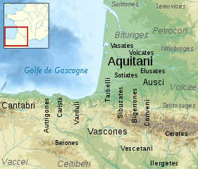
Mida d'aquesta previsualització PNG del fitxer SVG: 702 × 600 píxels. Altres resolucions: 281 × 240 píxels | 562 × 480 píxels | 899 × 768 píxels | 1.199 × 1.024 píxels | 2.398 × 2.048 píxels | 878 × 750 píxels.
Fitxer original (fitxer SVG, nominalment 878 × 750 píxels, mida del fitxer: 1,26 Mo)
| Aquest fitxer i la informació mostrada a continuació provenen del dipòsit multimèdia lliure Wikimedia Commons. |

Resum
| Descripció |
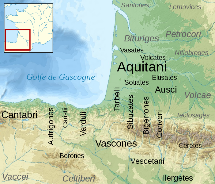
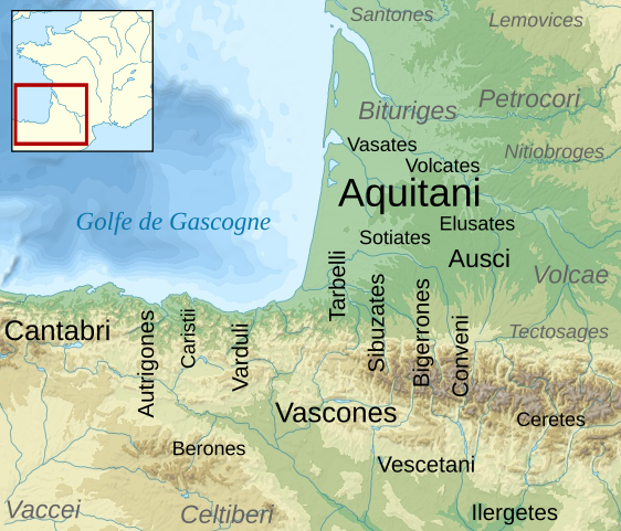
English: Map of the Aquitani and surrounding tribes in early Roman times.
Français : Carte des peuples de la Gaule Aquitaine au début de l'époque romaine.
|
||
| Data | |||
| Font |
|
||
| Autor | Sémhur | ||
| Altres versions | |||
| Reconeixement (required by the license) | © Sémhur / Wikimedia Commons / | ||
| SVG | W3C-validity not checked. Aquesta imatge vectorial ha estat creada amb Inkscape .
|
||
| Graphic Lab |

| Posició de la càmera | | Aquesta i altres imatges properes a: OpenStreetMap |
|---|
Llicència
Jo, el titular dels drets d'autor d'aquest treball, el public sota les següents llicències:
| Copyleft: Aquesta és una obra d'art lliure: Podeu redistribuir-la i modificar-la sota els termes de la Llicència d'Art Lliure. Trobareu una còpia d'aquesta llicència al web Copyleft Attitude, així com en altres llocs web. |
This file is licensed under the Creative Commons Attribution-Share Alike Attribution-Share Alike 4.0 International, 3.0 Unported, 2.5 Generic, 2.0 Generic and 1.0 Generic license.
- Sou lliure de:
- compartir – copiar, distribuir i comunicar públicament l'obra
- adaptar – fer-ne obres derivades
- Amb les condicions següents:
- reconeixement – Heu de donar la informació adequada sobre l'autor, proporcionar un enllaç a la llicència i indicar si s'han realitzat canvis. Podeu fer-ho amb qualsevol mitjà raonable, però de cap manera no suggereixi que l'autor us dóna suport o aprova l'ús que en feu.
- compartir igual – Si modifiqueu, transformeu, o generareu amb el material, haureu de distribuir les vostres contribucions sota una llicència similar o una de compatible com l'original
Podeu seleccionar la llicència que vulgueu.
Registre original de càrregues
This image is a derivative work of the following images:
- File:France_map_Lambert-93_topographic-blank.svg licensed with Cc-by-sa-3.0,2.5,2.0,1.0, GFDL
- 2008-11-13T17:24:53Z Sting 2000x1898 (1639447 Bytes) + boundary for Channel Islands ; - canals
- 2008-10-01T04:59:44Z Sting 2000x1898 (1682809 Bytes) == Summary == {{Location|46|15|00|N|02|06|00|E|scale:10000000}} {{Information |Description={{en|Blank topographic map of [[:en:France|France]] in the official Lambert-93 projection.}} {{fr|Carte topographique vierge de la [[
- File:Aquitani.gif licensed with PD-self
- 2007-01-25T14:16:29Z Michel BUZE 481x393 (10166 Bytes) {{Information |Description= *Author: [[:en:User:Sugaar|Sugaar]] *Sources: various (ultimately [[:en:Strabo]] and [[:en:Pliny]]) *Based on [[:en::Image:Basque tribes.gif]] (the only diference is that it tags the Aquitani confe
- File:Blank_map_of_Gaul_1st_century_BC.svg licensed with Cc-by-sa-2.5,2.0,1.0, GFDL
- 2007-07-07T19:30:39Z Historicair 755x784 (45078 Bytes) {{Information |Description={{fr}}Carte vierge de la Gaule au Ier siècle avant JC {{en}}Blank map of Gaul 1st century BC. |Source=[[:Image:Caesar's Campaigns in Gaul, 1st century BC.gif]] |Date=07/07/2007 |Author=~~~~ |Permis
Uploaded with derivativeFX
Historial del fitxer
Cliqueu una data/hora per veure el fitxer tal com era aleshores.
| Data/hora | Miniatura | Dimensions | Usuari/a | Comentari | |
|---|---|---|---|---|---|
| actual | 17:46, 17 feb 2009 | | 878 × 750 (1,26 Mo) | Sémhur | {{Information |Description= {{en|Map of the Aquitani and surrounding tribes in early Roman times. * Black: pre-Indoeuropean tribes. * Grey: Celtic tribes. ''Note: the macro-ethnicity of some of the tribes is disputed.''}} {{fr|Carte des peuples de la Ga |
Ús del fitxer
Les 11 pàgines següents utilitzen aquest fitxer:
Ús global del fitxer
Utilització d'aquest fitxer en altres wikis:
- Utilització a an.wikipedia.org
- Utilització a azb.wikipedia.org
- Utilització a az.wikipedia.org
- Utilització a bg.wikipedia.org
- Utilització a br.wikipedia.org
- Utilització a de.wikipedia.org
- Utilització a el.wikipedia.org
- Utilització a en.wikipedia.org
- Utilització a en.wiktionary.org
- Utilització a eo.wikipedia.org
- Utilització a eu.wikipedia.org
- Utilització a fi.wikipedia.org
- Utilització a fr.wikipedia.org
Vegeu més usos globals d'aquest fitxer.