
Fitxer:Lizars Mexico & Guatimala 1836 UTA (detail of Texas).jpg
Mida d'aquesta previsualització: 694 × 600 píxels. Altres resolucions: 278 × 240 píxels | 555 × 480 píxels | 889 × 768 píxels | 1.185 × 1.024 píxels | 1.357 × 1.173 píxels.
Fitxer original (1.357 × 1.173 píxels, mida del fitxer: 983 Ko, tipus MIME: image/jpeg)
| Aquest fitxer i la informació mostrada a continuació provenen del dipòsit multimèdia lliure Wikimedia Commons. |
Resum
| Títol |
English: Mexico & Guatimala [sic] |
||||||||||||||||||||||||||
| Descripció |
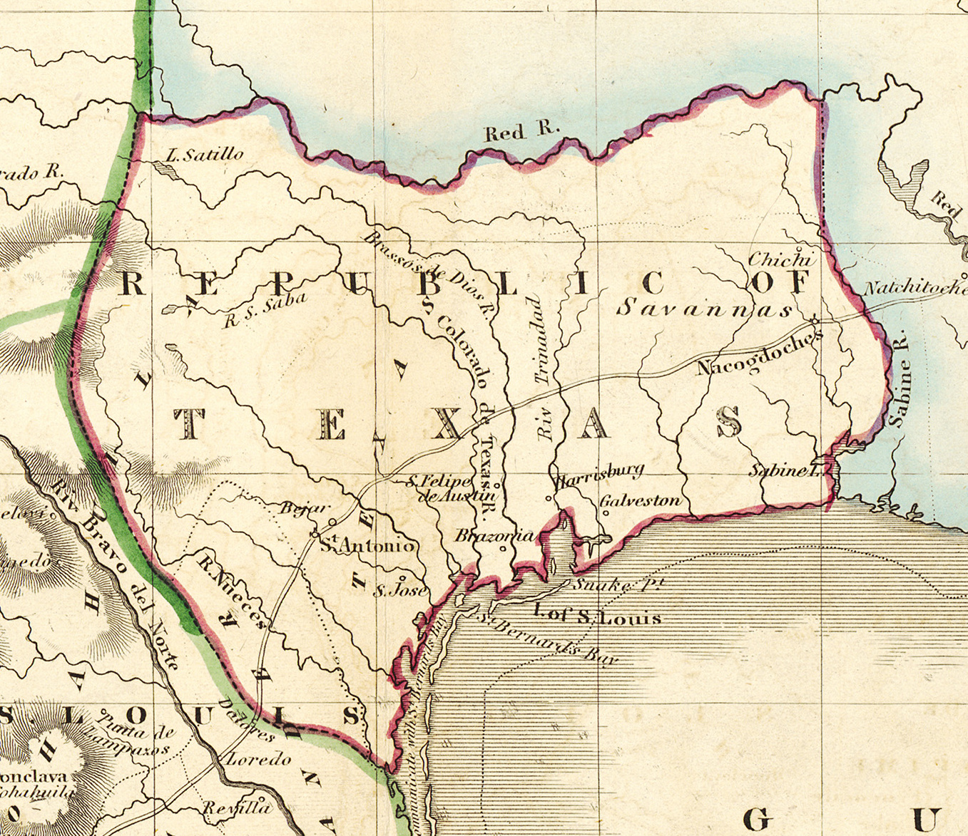
English: Shortly after Texas declared its independence from Mexico in 1836, the Edinburgh painter, engraver, printer, cartographer, lithographer, and publisher William Home Lizars (1788-1859), brother of Daniel Lizars II (1793-1875), updated the original plate for the map of Mexico & Guatemala to include the new republic. He added the towns of Galveston, Harrisburg, Brazoria, S. Felipe de Austin (although recently destroyed), Bejar, and "S. Jose" (probably intended to represent Goliad). Lizars made no further improvements to the general cartographic shape of the republic except to show the Nueces River as the southern boundary and the western boundary curving to the point where the 100th meridian strikes the Red River. The map continues to show Mexico's administrative districts as Spanish Intendencies (Intendencias) and Internal Provinces (Provincias Internas) over fifteen years since Mexico's independence. |
||||||||||||||||||||||||||
| Data | cap a 1836 | ||||||||||||||||||||||||||
| Font | UTA Libraries Cartographic Connections: mapa / texte | ||||||||||||||||||||||||||
| Creador |
|
||||||||||||||||||||||||||
| Crèdits d'adquisició |
English: The University of Texas at Arlington Libraries Special Collections, Gift of Lewis & Virginia Buttery |
||||||||||||||||||||||||||
| Geotemporal data | |||||||||||||||||||||||||||
| Map location | Texas | ||||||||||||||||||||||||||
| Georeferencing | If inappropriate please set warp_status = skip to hide. | ||||||||||||||||||||||||||
| Bibliographic data | |||||||||||||||||||||||||||
| Lloc de publicació | Edimburg | ||||||||||||||||||||||||||
| Editorial |
|
||||||||||||||||||||||||||
| Archival data | |||||||||||||||||||||||||||
| Col·lecció |
|
||||||||||||||||||||||||||
| Dimensions | altura: 42 cm; amplada: 51,5 cm | ||||||||||||||||||||||||||
| Material/Tècnica | gravat il·luminat sobre paper | ||||||||||||||||||||||||||
| artwork-references |
Worms, Laurence; Ashley Baynton-Williams (2011) British Map Engravers, Londres: Rare Book Society, p. 406–409 |
||||||||||||||||||||||||||
| Altres versions | |||||||||||||||||||||||||||

.jpg?uselang=ca)
Llicència

|
This file was provided to Wikimedia Commons by the University of Texas at Arlington Libraries as part of a cooperation project. The University of Texas at Arlington Libraries is part of the University of Texas at Arlington, a public research university located in Arlington, Texas.
|
|
Aquest material està en domini públic als Estats Units i als altres països on el dret d'autor s'estén per 100 anys (o menys) després de la mort de l'autor. Aquesta obra es troba en el domini públic als Estats Units d'Amèrica per haver estat publicada abans de l'1 de gener de 1929. | |
| Aquest fitxer està identificat com a lliure de restriccions conegudes sota la llei de drets d'autor, inclosos els drets veïns. | |
Historial del fitxer
Cliqueu una data/hora per veure el fitxer tal com era aleshores.
| Data/hora | Miniatura | Dimensions | Usuari/a | Comentari | |
|---|---|---|---|---|---|
| actual | 17:18, 13 jul 2019 | | 1.357 × 1.173 (983 Ko) | Michael Barera | File:Lizars Mexico & Guatimala 1836 UTA.jpg cropped 79 % horizontally, 78 % vertically using CropTool with precise mode. |
Ús del fitxer
La pàgina següent utilitza aquest fitxer:
Ús global del fitxer
Utilització d'aquest fitxer en altres wikis:
- Utilització a azb.wikipedia.org
- Utilització a cv.wikipedia.org
- Utilització a en.wikipedia.org
- Utilització a eo.wikipedia.org
- Utilització a fa.wikipedia.org
- Utilització a it.wikipedia.org
- Utilització a ja.wikipedia.org
- Utilització a ko.wikipedia.org
- Utilització a mk.wikipedia.org
- Utilització a mzn.wikipedia.org
- Utilització a pl.wikipedia.org
- Utilització a pt.wikipedia.org
- Utilització a sv.wikipedia.org
- Utilització a th.wikipedia.org
- Utilització a yi.wikipedia.org
- Utilització a zh-min-nan.wikipedia.org
.jpg)