
Fitxer:Weimar Republic states map.svg

Mida d'aquesta previsualització PNG del fitxer SVG: 715 × 599 píxels. Altres resolucions: 286 × 240 píxels | 573 × 480 píxels | 916 × 768 píxels | 1.222 × 1.024 píxels | 2.444 × 2.048 píxels | 976 × 818 píxels.
Fitxer original (fitxer SVG, nominalment 976 × 818 píxels, mida del fitxer: 949 Ko)
| Aquest fitxer i la informació mostrada a continuació provenen del dipòsit multimèdia lliure Wikimedia Commons. |
Resum
| Descripció |
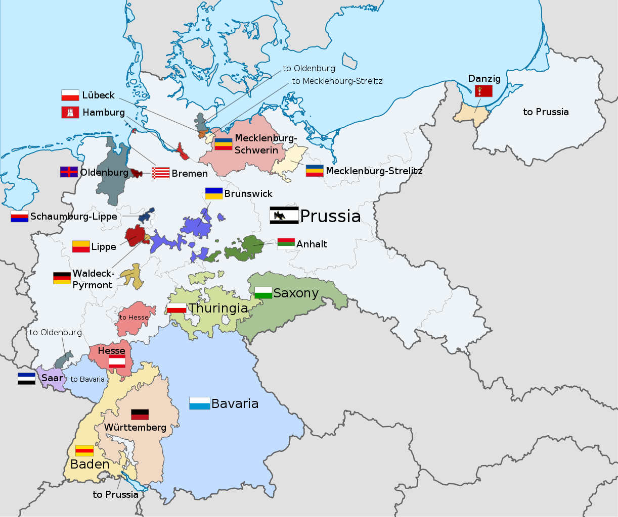
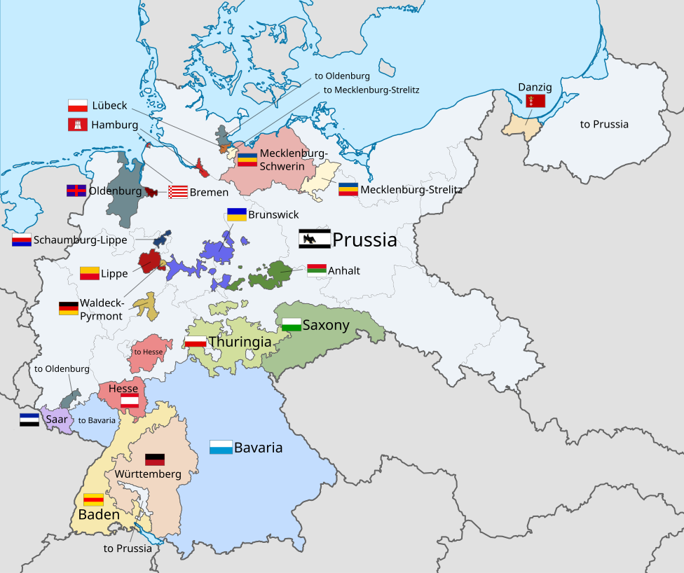
English: A map of the states of the Weimar Republic, showing their location, flags and names in English. |
| Data | |
| Font |
This file was derived from: Weimar Republic blank map.svg: This vector image includes elements that have been taken or adapted from this file: This vector image includes elements that have been taken or adapted from this file: This vector image includes elements that have been taken or adapted from this file: This vector image includes elements that have been taken or adapted from this file: This vector image includes elements that have been taken or adapted from this file: This vector image includes elements that have been taken or adapted from this file: This vector image includes elements that have been taken or adapted from this file: This vector image includes elements that have been taken or adapted from this file: This vector image includes elements that have been taken or adapted from this file: This vector image includes elements that have been taken or adapted from this file: This vector image includes elements that have been taken or adapted from this file: This vector image includes elements that have been taken or adapted from this file: This vector image includes elements that have been taken or adapted from this file: This vector image includes elements that have been taken or adapted from this file: This vector image includes elements that have been taken or adapted from this file: This vector image includes elements that have been taken or adapted from this file: |
| Autor |
|
| Altres versions |
|
| SVG genesis | Aquesta imatge vectorial ha estat creada amb Inkscape This flag uses embedded text that can be easily translated using a text editor. |


.svg)


.svg)
.svg)
.svg)
.svg)
Llicència
Jo, el titular dels drets d'autor d'aquest treball, el public sota la següent llicència:
Aquest fitxer està subjecte a la llicència de Creative Commons Reconeixement i Compartir Igual 3.0 No adaptada.
- Sou lliure de:
- compartir – copiar, distribuir i comunicar públicament l'obra
- adaptar – fer-ne obres derivades
- Amb les condicions següents:
- reconeixement – Heu de donar la informació adequada sobre l'autor, proporcionar un enllaç a la llicència i indicar si s'han realitzat canvis. Podeu fer-ho amb qualsevol mitjà raonable, però de cap manera no suggereixi que l'autor us dóna suport o aprova l'ús que en feu.
- compartir igual – Si modifiqueu, transformeu, o generareu amb el material, haureu de distribuir les vostres contribucions sota una llicència similar o una de compatible com l'original
Code for clickable map

Historial del fitxer
Cliqueu una data/hora per veure el fitxer tal com era aleshores.
| Data/hora | Miniatura | Dimensions | Usuari/a | Comentari | |
|---|---|---|---|---|---|
| actual | 00:22, 18 des 2021 | | 976 × 818 (949 Ko) | Alphathon | Corrections to Anhalt and Brunswick |
| 05:28, 5 nov 2015 |  | 976 × 818 (981 Ko) | Alphathon | {{Information |Description={{en|A map of the states of the en:Weimar Republic, showing their location, flags and names in English.}}{{Valid SVG}} |Source={{Derived from|File:Weimar Republic blank map.svg|display=50}} {{AttribSVG|Flag of Prussia (... |
Ús del fitxer
Les 2 pàgines següents utilitzen aquest fitxer:
Ús global del fitxer
Utilització d'aquest fitxer en altres wikis:
- Utilització a ar.wikipedia.org
- Utilització a ast.wikipedia.org
- Utilització a en.wikipedia.org
- Gleichschaltung
- Weimar Republic
- States of Germany
- Prussia
- Reichsrat (Germany)
- Reichsstatthalter
- States of the Weimar Republic
- Template:Weimar Republic States
- Provisional Law and Second Law on the Coordination of the States with the Reich
- Nazi Party election results
- Law on the Reconstruction of the Reich
- User:Falcaorib/Germany and Prussia
- Utilització a fa.wikipedia.org
- Utilització a fy.wikipedia.org
- Utilització a gd.wikipedia.org
- Utilització a hy.wikipedia.org
- Utilització a id.wikipedia.org
- Utilització a it.wikipedia.org
- Utilització a kk.wikipedia.org
- Utilització a lt.wikipedia.org
- Utilització a ms.wikipedia.org
- Utilització a pt.wikipedia.org
- Utilització a simple.wikipedia.org
- Utilització a tr.wikipedia.org
- Utilització a ur.wikipedia.org
- Utilització a zh.wikipedia.org