
Fitxer:Hawaii US Congressional District 2 (since 2013).tif

Mida d'aquesta previsualització PNG del fitxer TIF: 616 × 600 píxels. Altres resolucions: 247 × 240 píxels | 493 × 480 píxels | 828 × 806 píxels.
Fitxer original (828 × 806 píxels, mida del fitxer: 435 Ko, tipus MIME: image/tiff)
| Aquest fitxer i la informació mostrada a continuació provenen del dipòsit multimèdia lliure Wikimedia Commons. |
Resum
| Descripció |
English: Boundaries for Hawaii’s 2nd United States Federal Congressional District. |
| Data | |
| Font | GIS shapefile data created by the United States Department of the Interior, as part of the "1 Million Scale" geospatial data project. Retrieved from: http://nationalatlas.gov/atlasftp-1m.html?openChapters=#chpbound |
| Autor | 1: GIS (congressional districts, 2013) shapefile data was created by the United States Department of the Interior. 2: Data was rendered using ArcGIS® software by Esri. 3: File developed for use on Wikipedia and elsewhere by 7partparadigm. |
Llicència
This map was obtained from an edition of the National Atlas of the United States. Like almost all works of the U.S. federal government, works from the National Atlas are in the public domain in the United States.
Online access: NationalAtlas.gov | 1970 print edition: Library of Congress, Perry-Castañeda Library
|
Historial del fitxer
Cliqueu una data/hora per veure el fitxer tal com era aleshores.
| Data/hora | Miniatura | Dimensions | Usuari/a | Comentari | |
|---|---|---|---|---|---|
| actual | 22:11, 10 abr 2014 | 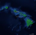 | 828 × 806 (435 Ko) | 7partparadigm | User created page with UploadWizard |
Ús del fitxer
La pàgina següent utilitza aquest fitxer:
Ús global del fitxer
Utilització d'aquest fitxer en altres wikis:
- Utilització a en.wikipedia.org
- Utilització a fr.wikipedia.org
- Utilització a simple.wikipedia.org
- Utilització a www.wikidata.org
- Utilització a zh.wikipedia.org