
Fitxer:Magnetic North Pole Positions 2015.svg

Mida d'aquesta previsualització PNG del fitxer SVG: 401 × 599 píxels. Altres resolucions: 160 × 240 píxels | 321 × 480 píxels | 514 × 768 píxels | 685 × 1.024 píxels | 1.370 × 2.048 píxels | 445 × 665 píxels.
Fitxer original (fitxer SVG, nominalment 445 × 665 píxels, mida del fitxer: 808 Ko)
| Aquest fitxer i la informació mostrada a continuació provenen del dipòsit multimèdia lliure Wikimedia Commons. |
Resum
| Descripció |
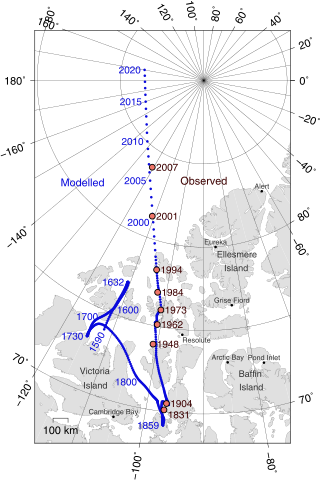
English: Positions of North Magnetic Pole of the Earth. Poles shown are dip poles, defined as positions where the direction of the magnetic field is vertical. Red circles mark magnetic north pole positions as determined by direct observation, blue circles mark positions modelled using the GUFM model (1590–1890) and the IGRF-12 model (1900–2020) in 1 year increments. For the years 1890–1900, a smooth interpolation between the two models was performed. The modelled locations after 2015 are projections.
Українська: Північний магнітний полюс, що розташовується на Землі. Магнітне поле показує диполь, визначений позиціями де напрям магнітного поля вертикальний. Червоні кільця позначки північного магнітного поля визначені прямим спостереженням, голубі кільця позначки позиції змодельовані GUFM модель (1590-1890) та IGRF-12 (International Geomagnetic Reference Field Model) модель (1900-2020) з кроком в один рік. Для років 1890-1900, гладка інтерполяція виконана між двома моделями. Змодельовані місця після 2015 року є проекціями.
Русский: Географическое положение северного магнитного полюса Земли. Полюса, показанные на карте, подразумеваются полюсами магнитного диполя, и в точках их расположение наклонение магнитного поля вертикально. Красными кружками обозначены места, обнаруженные прямыми наблюдениями. Синие кружки - места, вычисленные по моделям «GUFM» (1590–1890) и «IGRF-12» (1900–2020) с временным шагом в 1 год. Для 1890–1900 годов, была осуществлена плавная интерполяция между двумя моделями. Смоделированные положения после 2015 года - предположительны. |
| Data | |
| Font |
Treball propi |
| Autor | Cavit |
| Altres versions |
|
| SVG genesis |

Llicència
Jo, el titular dels drets d'autor d'aquest treball, el public sota la següent llicència:
This file is licensed under the Creative Commons Attribution 4.0 International license.
- Sou lliure de:
- compartir – copiar, distribuir i comunicar públicament l'obra
- adaptar – fer-ne obres derivades
- Amb les condicions següents:
- reconeixement – Heu de donar la informació adequada sobre l'autor, proporcionar un enllaç a la llicència i indicar si s'han realitzat canvis. Podeu fer-ho amb qualsevol mitjà raonable, però de cap manera no suggereixi que l'autor us dóna suport o aprova l'ús que en feu.
GMT Source Code
GMT (Generic Mapping Tools), http://gmt.soest.hawaii.edu/ archive copy at the Wayback Machine
@echo off
set PS=magpole2.ps
pscoast -Di -JE-90/90/10c -R-115/66/30/84r -Bxa20g10 -Bya10g5 -A150 -L-113/68/80/100 --MAP_POLAR_CAP=none --MAP_FRAME_TYPE=plain --MAP_FRAME_PEN=0.6p -G224/224/224 -W,130/130/130 -Swhite -K > %PS%
psxy NP.xy -J -R -O -K -Sc0.1c -G10/10/220 >> %PS%
psxy observations.txt -J -R -O -K -Sc0.23c -G240/117/104 -Wthick,0/0/0 >> %PS%
pstext -J -R -Dj0.15c/0.05c observations.txt -F+f11,Helvetica,60/0/0+j -O -K >> %PS%
pstext -J -R -Dj0.15c/0.05c modellabels.txt -F+f11,Helvetica,10/10/220+j+a -O -K >> %PS%
pstext -J -R legend.txt -F+f -O -K >> %PS%
psxy cities.txt -J -R -O -K -Sc0.1c -G0/0/0 >> %PS%
pstext -J -R cities.txt -F+f8,Helvetica,50/50/50+j -Dj0c/0.1c -O -K >> %PS%
pstext -J -R labels.txt -F+f10,Helvetica,50/50/50 -O >> %PS%
}}
}}

==observations.txt==
Observed pole positions taken from Newitt et al., "[http://www.terrapub.co.jp/journals/EPS/pdf/2009/6106/61060703.pdf Location of the North Magnetic Pole in April 2007]", Earth Planets Space, 61, 703–710, 2009

<syntaxhighlight>
-120.72	83.95	LM 2007
-110.80	81.30	LM 2001
-104.0	78.30	LM 1994
-102.3	77.0	LM 1984
-100.6	76.0	LM 1973
-100.8	75.1	LM 1962
-100.9	73.9	LM 1948
-96.6	70.5	LM 1904
-96.9 70.1 LT 1831Historial del fitxer
Cliqueu una data/hora per veure el fitxer tal com era aleshores.
| Data/hora | Miniatura | Dimensions | Usuari/a | Comentari | |
|---|---|---|---|---|---|
| actual | 20:18, 11 feb 2016 | | 445 × 665 (808 Ko) | Cavit | Added scale bar. |
| 21:52, 9 feb 2016 |  | 445 × 665 (805 Ko) | Cavit | Added white background. | |
| 21:48, 9 feb 2016 |  | 445 × 665 (635 Ko) | Cavit | User created page with UploadWizard |
Ús del fitxer
La pàgina següent utilitza aquest fitxer:
Ús global del fitxer
Utilització d'aquest fitxer en altres wikis:
- Utilització a af.wikipedia.org
- Utilització a am.wikipedia.org
- Utilització a ast.wikipedia.org
- Utilització a bg.wikipedia.org
- Utilització a cs.wikipedia.org
- Utilització a cv.wikipedia.org
- Utilització a de.wikipedia.org
- Utilització a el.wikipedia.org
- Utilització a en.wikipedia.org
- Utilització a en.wikiversity.org
- Utilització a es.wikipedia.org
- Utilització a fi.wikipedia.org
- Utilització a fr.wikipedia.org
- Pôle Nord magnétique
- Discussion:Pôle Nord magnétique
- Wikipédia:Statistiques des anecdotes de la page d'accueil/Visibilité des anecdotes (2018)
- Discussion:Pôle Nord magnétique/LSV 14945
- Wikipédia:Statistiques des anecdotes de la page d'accueil/Visibilité des anecdotes (2018)/2018 07
- Projet:Aide et accueil/Twitter/Tweets/archives/juillet 2018
- Wikipédia:Le saviez-vous ?/Archives/2018
- Utilització a fy.wikipedia.org
- Utilització a gl.wikipedia.org
- Utilització a hr.wikipedia.org
- Utilització a hu.wikipedia.org
- Utilització a it.wikipedia.org
- Utilització a lb.wikipedia.org
- Utilització a nds.wikipedia.org
- Utilització a no.wikipedia.org
- Utilització a pl.wikipedia.org
- Utilització a pt.wikipedia.org
- Utilització a ru.wikipedia.org
- Utilització a tr.wikipedia.org
- Utilització a uk.wikipedia.org
- Utilització a ur.wikipedia.org
- Utilització a vi.wikipedia.org
- Utilització a zh.wikipedia.org