Fitxer:Geographic distribution of Bengali language.png

El contingut de la pàgina no s'admet en altres llengües.
De la Viquipèdia, l'enciclopèdia lliure

Fitxer original(2.806 × 2.080 píxels, mida del fitxer: 1,36 Mo, tipus MIME: image/png)

Descripció a Commons

Resum

Descripció
Ελληνικά: Γεωγραφική κατανομή της Βεγγαλικής Γλώσσας ανά επαρχία της Ινδίας και στο Μπανγκλαντές, τα χρώματα στις επαρχίες ποικίλουν ανάλογα με το ποσοστό ομιλητών (δεδομένα απογραφής 2011). Παράγωγο του αρχείου India district map (de-facto).svg.
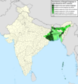
English: Geographic distribution of Bengali language in India and Bangladesh. The map covers each district of India and the five shades of green show the percentage of Bengali language speakers in each district. Source: Indian census 2011. Feel free to enrich the map with data for more Indian districts, or fix any mistakes. Derivative of the file India district map (de-facto).svg.
Data
Font Treball propi
Autor NikosLikomitros

Llicència

Jo, el titular dels drets d'autor d'aquest treball, el public sota la següent llicència:
w:ca:Creative Commons
reconeixement compartir igual
This file is licensed under the Creative Commons Attribution-Share Alike 4.0 International license.
Sou lliure de:
  • compartir – copiar, distribuir i comunicar públicament l'obra
  • adaptar – fer-ne obres derivades
Amb les condicions següents:
  • reconeixement – Heu de donar la informació adequada sobre l'autor, proporcionar un enllaç a la llicència i indicar si s'han realitzat canvis. Podeu fer-ho amb qualsevol mitjà raonable, però de cap manera no suggereixi que l'autor us dóna suport o aprova l'ús que en feu.
  • compartir igual – Si modifiqueu, transformeu, o generareu amb el material, haureu de distribuir les vostres contribucions sota una llicència similar o una de compatible com l'original

Llegendes

Afegeix una explicació d'una línia del que representa aquest fitxer
Geographic distribution of Bengali language in India and Bangladesh. The map covers each district of India and the five shades of green show the percentage of Bengali language speakers in each district. Source: Indian census 2011.

Elements representats en aquest fitxer

representa l'entitat

Historial del fitxer

Cliqueu una data/hora per veure el fitxer tal com era aleshores.

Data/horaMiniaturaDimensionsUsuari/aComentari
actual17:05, 2 jul 2022Miniatura per a la versió del 17:05, 2 jul 20222.806 × 2.080 (1,36 Mo)NikosLikomitrosA few districts of Arunachal Pradesh have a notable Bengali presence above of 1%, probably part of the Indian efforts to increase its presence in the region.
18:55, 1 jul 2022Miniatura per a la versió del 18:55, 1 jul 20222.806 × 2.080 (1,36 Mo)NikosLikomitrosTwo extra fixes.
18:53, 1 jul 2022Miniatura per a la versió del 18:53, 1 jul 20222.806 × 2.080 (1,36 Mo)NikosLikomitrosMinor fixes.
18:44, 1 jul 2022Miniatura per a la versió del 18:44, 1 jul 20222.806 × 2.080 (1,36 Mo)NikosLikomitrosNow, this map covers all districts of India. Includes also extra information and a new colour key. The basemap is from Distribution_of_Jats_in_South_Asia.png.
23:09, 26 juny 2022Miniatura per a la versió del 23:09, 26 juny 20221.902 × 2.048 (1.002 Ko)NikosLikomitrosUploaded own work with UploadWizard

No hi ha pàgines que utilitzin aquest fitxer.

Ús global del fitxer

Utilització d'aquest fitxer en altres wikis:

Metadades