
Fitxer:Near Mestia, Svan towers (35252565354).jpg

Fitxer original (5.184 × 3.456 píxels, mida del fitxer: 9,69 Mo, tipus MIME: image/jpeg)
| Aquest fitxer i la informació mostrada a continuació provenen del dipòsit multimèdia lliure Wikimedia Commons. |
.jpg?uselang=ca)
Resum
| Descripció |
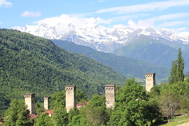
Mestia is a highland townlet in northwest Georgia, at an elevation of 1,500 metres in the Caucasus Mountains. Mestia is located in the Svaneti region of Samegrelo-Zemo Svaneti province. Mestia and the adjoining 132 villages form Mestia District (raioni). Its area is 30,444 square kilometres and its population is 14,248 (2,600 in the town itself), according to the 2002 Georgia census. It was granted the status of a townlet (Georgian: daba) in 1968. Historically and ethnographically, Mestia has always been regarded a chief community of Zemo, or Upper Svaneti province. The population is mostly Svans, a cultural and linguistic subgroup of the Georgians. Despite its small size, the townlet was an important centre of Georgian culture for centuries and contains a number of medieval monuments, such as churches and forts, included in a list of UNESCO World Heritage Sites. The townlet is dominated by stone defensive towers of a type seen in Ushguli ("Svan towers"). A typical Svan fortified dwelling consisted of a tower, an adjacent house (machub) and some other household structures encircled by a defensive wall. (source: <a href="https://en.wikipedia.org/wiki/Mestia" rel="nofollow">en.wikipedia.org/wiki/Mestia</a>) |
| Data | |
| Font | Near Mestia, Svan towers |
| Autor | Arian Zwegers from Brussels, Belgium |
| Posició de la càmera | | Aquesta i altres imatges properes a: OpenStreetMap |
|---|
.jpg¶ms=043.031098_N_0042.685876_E_globe:Earth_type:camera_source:Flickr_&language=ca)
Llicència
- Sou lliure de:
- compartir – copiar, distribuir i comunicar públicament l'obra
- adaptar – fer-ne obres derivades
- Amb les condicions següents:
- reconeixement – Heu de donar la informació adequada sobre l'autor, proporcionar un enllaç a la llicència i indicar si s'han realitzat canvis. Podeu fer-ho amb qualsevol mitjà raonable, però de cap manera no suggereixi que l'autor us dóna suport o aprova l'ús que en feu.
| This image was originally posted to Flickr by Arian Zwegers at https://flickr.com/photos/67769030@N07/35252565354 (archive). It was reviewed on 4 de novembre de 2018 by FlickreviewR 2 and was confirmed to be licensed under the terms of the cc-by-2.0. |
Historial del fitxer
Cliqueu una data/hora per veure el fitxer tal com era aleshores.
| Data/hora | Miniatura | Dimensions | Usuari/a | Comentari | |
|---|---|---|---|---|---|
| actual | 09:51, 4 nov 2018 | | 5.184 × 3.456 (9,69 Mo) | Kober | Transferred from Flickr via #flickr2commons |
Ús del fitxer
No hi ha pàgines que utilitzin aquest fitxer.
Ús global del fitxer
Utilització d'aquest fitxer en altres wikis:
- Utilització a en.wikipedia.org
- Utilització a mt.wikipedia.org
- Utilització a ru.wikipedia.org
.jpg)