
Fitxer:Relief Map of Czech Republic.png

Mida d'aquesta previsualització: 800 × 486 píxels. Altres resolucions: 320 × 195 píxels | 640 × 389 píxels | 1.000 × 608 píxels.
Fitxer original (1.000 × 608 píxels, mida del fitxer: 866 Ko, tipus MIME: image/png)
| Aquest fitxer i la informació mostrada a continuació provenen del dipòsit multimèdia lliure Wikimedia Commons. |
Resum
| Descripció |
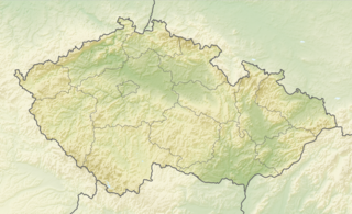
English: Relief map of the Czech Republic
Equirectangular projection, N/S stretching 150 %. Geographic limits of the map:
|
| Data | |
| Font |
|
| Autor | derivative work Виктор_В |
Llicència
Aquest fitxer està subjecte a la llicència de Creative Commons Reconeixement i Compartir Igual 3.0 No adaptada.
- Sou lliure de:
- compartir – copiar, distribuir i comunicar públicament l'obra
- adaptar – fer-ne obres derivades
- Amb les condicions següents:
- reconeixement – Heu de donar la informació adequada sobre l'autor, proporcionar un enllaç a la llicència i indicar si s'han realitzat canvis. Podeu fer-ho amb qualsevol mitjà raonable, però de cap manera no suggereixi que l'autor us dóna suport o aprova l'ús que en feu.
- compartir igual – Si modifiqueu, transformeu, o generareu amb el material, haureu de distribuir les vostres contribucions sota una llicència similar o una de compatible com l'original
Historial del fitxer
Cliqueu una data/hora per veure el fitxer tal com era aleshores.
| Data/hora | Miniatura | Dimensions | Usuari/a | Comentari | |
|---|---|---|---|---|---|
| actual | 10:37, 11 gen 2021 | | 1.000 × 608 (866 Ko) | ThecentreCZ | Reverted to version as of 11:53, 28 August 2010 (UTC) V Ústavním pořádku České republiky nemají zemské hranice žádné ukotvení a jsou jen přežitkem |
| 00:48, 11 gen 2021 |  | 1.000 × 608 (780 Ko) | Osidor | přidány zemské hranice (důvod: na mapě jsou užitečné nejméně stejně jako ty krajské [spíše však více]) | |
| 13:53, 28 ago 2010 |  | 1.000 × 608 (866 Ko) | Виктор В | == {{int:filedesc}} == {{Information |Description={{en|Location map of the Czech Republic}} Equirectangular projection, N/S stretching 150 %. Geographic limits of the map: * N: 51.3° N * S: 48.3° N * W: 11.8° E * O: 19.2° |
Ús del fitxer
Les 2 pàgines següents utilitzen aquest fitxer:
Ús global del fitxer
Utilització d'aquest fitxer en altres wikis:
- Utilització a als.wikipedia.org
- Utilització a arz.wikipedia.org
- Utilització a ast.wikipedia.org
- Utilització a azb.wikipedia.org
- Utilització a az.wikipedia.org
- Utilització a ba.wikipedia.org
- Utilització a be-tarask.wikipedia.org
- Utilització a be.wikipedia.org
- Utilització a bg.wikipedia.org
Vegeu més usos globals d'aquest fitxer.