
Fitxer:9 dotted line.png

Mida d'aquesta previsualització: 487 × 600 píxels. Altres resolucions: 195 × 240 píxels | 390 × 480 píxels | 979 × 1.206 píxels.
Fitxer original (979 × 1.206 píxels, mida del fitxer: 1,79 Mo, tipus MIME: image/png)
| Aquest fitxer i la informació mostrada a continuació provenen del dipòsit multimèdia lliure Wikimedia Commons. |
Resum
| Descripció |
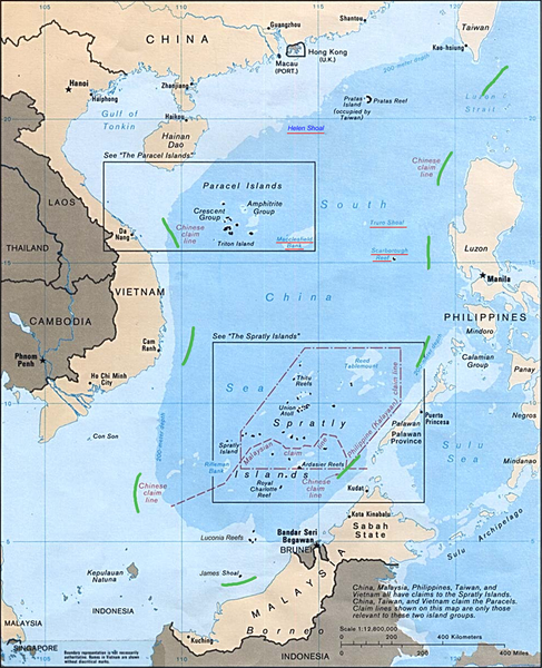
English: Map of the South China Sea, with 9-dotted line highlighted in green |
| Data | |
| Font | Asia Maps — Perry-Castañeda Map Collection: South China Sea (Islands) 1988 |
| Autor | U.S. Central Intelligence Agency |
| Altres versions | file:Schina_sea_88.png |
Llicència
| This image is a work of a Central Intelligence Agency employee, taken or made as part of that person's official duties. As a Work of the United States Government, this image or media is in the public domain in the United States.
|

|
Registre original de càrregues
La pàgina de descripció original era aquí. Els noms d'usuari a continuació es refereixen a en.wikipedia.
- 2011-10-20 18:05 JasonAQuest 979×1206× (1880133 bytes) {{Information |Description=Map of the South China Sea, with 9-dotted line highlighted in green |Source=[http://www.lib.utexas.edu/maps/asia.html Asia Maps — Perry-Castañeda Map Collection]: South China Sea (Islands) 1988 |Date=1988 |Author=U.S. Central Intelligence Agency |Permission={{PD-USGov-CIA}} |other_versions=Schina sea 88.png }} [[Category:South China Sea]] [[Category:Spratly Islands]] [[Category:Paracel Islands]]
Historial del fitxer
Cliqueu una data/hora per veure el fitxer tal com era aleshores.
| Data/hora | Miniatura | Dimensions | Usuari/a | Comentari | |
|---|---|---|---|---|---|
| actual | 00:29, 22 oct 2011 | | 979 × 1.206 (1,79 Mo) | Cantons-de-l'Est | {{Information |Description={{en|Map of the South China Sea, with 9-dotted line highlighted in green<br/> en:Category:South China Sea en:Category:Spratly Islands en:Category:Paracel Islands}} |Source=Transferred from [http://en.wikipedia. |
Ús del fitxer
La pàgina següent utilitza aquest fitxer:
Ús global del fitxer
Utilització d'aquest fitxer en altres wikis:
- Utilització a ar.wikipedia.org
- Utilització a az.wikipedia.org
- Utilització a cs.wikipedia.org
- Utilització a de.wikipedia.org
- Utilització a en.wikipedia.org
- Utilització a es.wikipedia.org
- Utilització a it.wikipedia.org
- Utilització a ja.wikipedia.org
- Utilització a ko.wikipedia.org
- Utilització a no.wikipedia.org
- Utilització a pl.wikipedia.org
- Utilització a pt.wikipedia.org
- Utilització a ru.wikipedia.org
- Utilització a sv.wikipedia.org
- Utilització a ta.wikipedia.org
- Utilització a th.wikipedia.org
- Utilització a tr.wikipedia.org
- Utilització a uk.wikipedia.org
- Utilització a www.wikidata.org
- Utilització a zh.wikipedia.org
- Utilització a zh.wikinews.org