
Fitxer:Aerial-View-Minamitori-Island-1987.jpg

Mida d'aquesta previsualització: 800 × 507 píxels. Altres resolucions: 320 × 203 píxels | 640 × 405 píxels | 1.024 × 649 píxels | 1.280 × 811 píxels | 2.824 × 1.789 píxels.
Fitxer original (2.824 × 1.789 píxels, mida del fitxer: 1,09 Mo, tipus MIME: image/jpeg)
| Aquest fitxer i la informació mostrada a continuació provenen del dipòsit multimèdia lliure Wikimedia Commons. |
Resum
| Descripció |
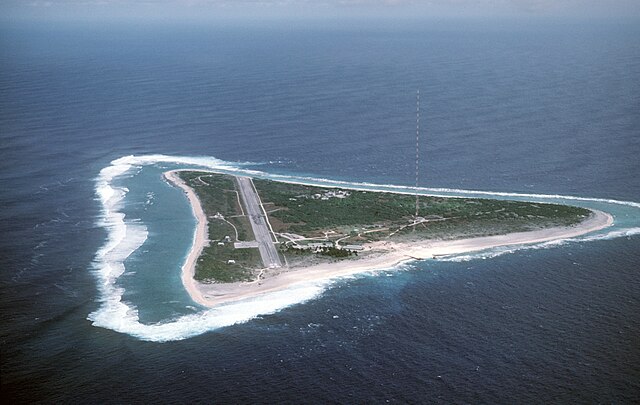
English: Aerial view of Minamitori Island (Minami-Torishima), Japan. There is a runway which supported the US Coast Guard station located there prior to 1993. Minamitori Island is the easternmost island of the Japanese archipelago.
Deutsch: Luftaufnahme der Minamitori Insel (Minami-Torishima), Japan.
日本語: 南鳥島の空中写真。 |
|||
| Data | ||||
| Font |
|
|||
| Autor | Chief Master Sergeant Don Sutherland, U.S. Air Force |
Llicència
Aquest fitxer és un treball de les Forces Armades dels EUA o d'un treballador Departament de Defensa dels EUA, presa o feta durant el decurs de la feina oficial d'un treballador. Com a treball del Govern federal dels Estats Units, aquest fitxer es troba en domini públic.
Vegeu http://www.defenselink.mil/multimedia/about.html.
|
 |
Historial del fitxer
Cliqueu una data/hora per veure el fitxer tal com era aleshores.
| Data/hora | Miniatura | Dimensions | Usuari/a | Comentari | |
|---|---|---|---|---|---|
| actual | 03:38, 18 gen 2007 | | 2.824 × 1.789 (1,09 Mo) | Balcer~commonswiki | ID: DFST8708298 Service Depicted: Coalition or Allied Forces Aerial view of Marcus Island and the runway which supports the US Coast Guard station located there. Marcus Island is the southernmost island in the Japanese chain. Camera Operator: CMSGT |
Ús del fitxer
Les 2 pàgines següents utilitzen aquest fitxer:
Ús global del fitxer
Utilització d'aquest fitxer en altres wikis:
- Utilització a ar.wikipedia.org
- Utilització a ast.wikipedia.org
- Utilització a az.wikipedia.org
- Utilització a be.wikipedia.org
- Utilització a ceb.wikipedia.org
- Utilització a cs.wikipedia.org
- Utilització a de.wikipedia.org
- Utilització a el.wikipedia.org
- Utilització a en.wikipedia.org
- Utilització a es.wikipedia.org
- Utilització a et.wikipedia.org
- Utilització a eu.wikipedia.org
- Utilització a fa.wikipedia.org
- Utilització a fi.wikipedia.org
- Utilització a frr.wikipedia.org
- Utilització a fr.wikipedia.org
- Utilització a fr.wiktionary.org
- Utilització a gl.wikipedia.org
- Utilització a hy.wikipedia.org
- Utilització a it.wikipedia.org
- Utilització a ja.wikipedia.org
- Utilització a ja.wikibooks.org
- Utilització a ko.wikipedia.org
Vegeu més usos globals d'aquest fitxer.