
Fitxer:Bastogne Map December 19-23 1944.jpg
Mida d'aquesta previsualització: 800 × 477 píxels. Altres resolucions: 320 × 191 píxels | 640 × 381 píxels | 1.024 × 610 píxels | 1.556 × 927 píxels.
Fitxer original (1.556 × 927 píxels, mida del fitxer: 1,19 Mo, tipus MIME: image/jpeg)
| Aquest fitxer i la informació mostrada a continuació provenen del dipòsit multimèdia lliure Wikimedia Commons. |
Resum
| Descripció | ||||||||||
| Data | ||||||||||
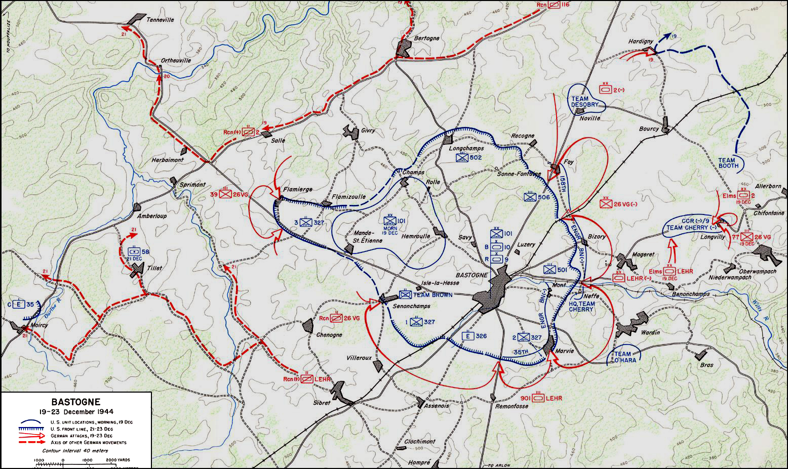
| Font | United States Army Center of Military History | |||||||||
| Creador | ||||||||||
| Geotemporal data | ||||||||||
| Data representada | 19 de desembre de 1944 fins 23 de desembre de 1944 | |||||||||
| Map location | Bastogne | |||||||||
| Heading |
 |
|||||||||
| Bounding box |
|
|||||||||
| Georeferencing | ||||||||||

|
Aquesta imatge (de tipus military map) s'hauria de tornar a crear utilitzant gràfics vectorials com ara un fitxer SVG. Això té diversos avantatges; en trobareu més informació a Commons:Media for cleanup. Si ja disposeu d'una versió d'aquesta imatge en format SVG, us preguem que la pengeu; després, reemplaceu aquesta plantilla amb la plantilla {{Vector version available|nom nou de la imatge.svg}} en aquesta imatge.
|


Llicència
| This image is in the public domain because it contains materials that originally came from the United States Army Center of Military History, subject to the following qualification.
Note: The images of all badges, insignia, decorations and medals on the "CMH Online" web site are produced by the United States Army Institute of Heraldry and protected by Title 18, United States Code, Section 704 and the Code of Federal Regulations (32 CFR, Part 507). Permission to use these images for commercial purposes must be obtained from The Institute of Heraldry prior to their use. |

|
Historial del fitxer
Cliqueu una data/hora per veure el fitxer tal com era aleshores.
| Data/hora | Miniatura | Dimensions | Usuari/a | Comentari | |
|---|---|---|---|---|---|
| actual | 06:59, 4 nov 2006 | | 1.556 × 927 (1,19 Mo) | CORNELIUSSEON | {{Information |Description=Bastogne, Belgium Map; december 19-23, 1944. |Source=US Army Center for Military History |Date=December 19-23, 1944 |Author= |Permission={{PD-USGov-Military-Army-USACMH}} – US Army Center for Military History |other_versions= |
Ús del fitxer
La pàgina següent utilitza aquest fitxer:
Ús global del fitxer
Utilització d'aquest fitxer en altres wikis:
- Utilització a ar.wikipedia.org
- Utilització a de.wikipedia.org
- Utilització a el.wikipedia.org
- Utilització a en.wikipedia.org
- Utilització a en.wikisource.org
- Utilització a es.wikipedia.org
- Utilització a he.wikipedia.org
- Utilització a it.wikipedia.org
- Utilització a ja.wikipedia.org
- Utilització a nl.wikipedia.org
- Utilització a ru.wikipedia.org
- Utilització a sl.wikipedia.org
- Utilització a ta.wikipedia.org
- Utilització a tr.wikipedia.org
- Utilització a www.wikidata.org
- Utilització a zh.wikipedia.org