
Fitxer:BattleaxeContestedArea.svg

Mida d'aquesta previsualització PNG del fitxer SVG: 438 × 457 píxels. Altres resolucions: 230 × 240 píxels | 460 × 480 píxels | 736 × 768 píxels | 981 × 1.024 píxels | 1.963 × 2.048 píxels.
Fitxer original (fitxer SVG, nominalment 438 × 457 píxels, mida del fitxer: 219 Ko)
| Aquest fitxer i la informació mostrada a continuació provenen del dipòsit multimèdia lliure Wikimedia Commons. |
Resum
| Descripció |
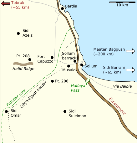
English: A map of the area in which Operations Brevity and Battleaxe were fought |
| Data | |
| Font |
Based on en:File:BattleaxeContestedArea.JPG, with verifiable data from:
|
| Autor | Jappalang |
| Altres versions |
Derivative works of this file: BattleaxeContestedArea-de.svg en:File:BattleaxeContestedArea.JPG |
Llicència
Jo, el titular dels drets d'autor d'aquest treball, el public sota les següents llicències:
Aquest fitxer està subjecte a la llicència de Creative Commons Reconeixement i Compartir Igual 3.0 No adaptada.
- Sou lliure de:
- compartir – copiar, distribuir i comunicar públicament l'obra
- adaptar – fer-ne obres derivades
- Amb les condicions següents:
- reconeixement – Heu de donar la informació adequada sobre l'autor, proporcionar un enllaç a la llicència i indicar si s'han realitzat canvis. Podeu fer-ho amb qualsevol mitjà raonable, però de cap manera no suggereixi que l'autor us dóna suport o aprova l'ús que en feu.
- compartir igual – Si modifiqueu, transformeu, o generareu amb el material, haureu de distribuir les vostres contribucions sota una llicència similar o una de compatible com l'original

|
S'autoritza la còpia, la distribució i la modificació d'aquest document sota els termes de la llicència de documentació lliure GNU versió 1.2 o qualsevol altra versió posterior que publiqui la Free Software Foundation; sense seccions invariants, ni textos de portada, ni textos de contraportada. S'inclou una còpia d'aquesta llicència en la secció titulada GNU Free Documentation License. |
Podeu seleccionar la llicència que vulgueu.
Historial del fitxer
Cliqueu una data/hora per veure el fitxer tal com era aleshores.
| Data/hora | Miniatura | Dimensions | Usuari/a | Comentari | |
|---|---|---|---|---|---|
| actual | 16:44, 15 juny 2014 | | 438 × 457 (219 Ko) | Hohum | Cartographic colours |
| 00:55, 3 març 2009 |  | 438 × 457 (219 Ko) | Jappalang | Converted fonts (objects) to paths | |
| 00:15, 10 gen 2009 |  | 438 × 457 (41 Ko) | Jappalang | Enhancement of the country border text | |
| 16:16, 9 gen 2009 |  | 438 × 457 (40 Ko) | Jappalang | {{Information |Description={{en|1=A map of the area in which Operations Brevity and Battleaxe were fought}} |Source=Based on en:BattleaxeContestedArea.JPG, with verifiable data from Google Maps, en:File:Operation Brevity.jpg, and Jon Latimer and |
Ús del fitxer
Les 5 pàgines següents utilitzen aquest fitxer:
Ús global del fitxer
Utilització d'aquest fitxer en altres wikis:
- Utilització a ar.wikipedia.org
- Utilització a en.wikipedia.org
- Utilització a es.wikipedia.org
- Utilització a fa.wikipedia.org
- Utilització a fi.wikipedia.org
- Utilització a fr.wikipedia.org
- Utilització a he.wikipedia.org
- Utilització a it.wikipedia.org
- Utilització a ko.wikipedia.org
- Utilització a nl.wikipedia.org
- Utilització a pl.wikipedia.org
- Utilització a ru.wikipedia.org
- Utilització a sr.wikipedia.org
- Utilització a ta.wikipedia.org
- Utilització a vi.wikipedia.org
- Utilització a www.wikidata.org
- Utilització a zh.wikipedia.org