
Fitxer:Brong Ahafo districts.png

Mida d'aquesta previsualització: 776 × 600 píxels. Altres resolucions: 311 × 240 píxels | 621 × 480 píxels | 994 × 768 píxels | 1.056 × 816 píxels.
Fitxer original (1.056 × 816 píxels, mida del fitxer: 49 Ko, tipus MIME: image/png)
| Aquest fitxer i la informació mostrada a continuació provenen del dipòsit multimèdia lliure Wikimedia Commons. |
Resum
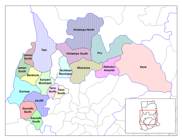
| Descripció | Map of the districts of the Brong Ahafo region of Ghana. Created by Rarelibra for public domain use. Created using MapInfo Professional v7.5 and various mapping resources. |
| Data | 28 de juny de 2006 (original upload date) |
| Font | No machine-readable source provided. Own work assumed (based on copyright claims). |
| Autor | No machine-readable author provided. Ahanta assumed (based on copyright claims). |
Llicència
| Jo, el titular del copyright d'aquesta obra, l'allibero al domini públic. Això s'aplica a tot el món. En alguns països això pot no ser legalment possible, en tal cas: Jo faig concessió a tothom del dret d'usar aquesta obra per a qualsevol propòsit, sense cap condició llevat d'aquelles requerides per la llei. |
Historial del fitxer
Cliqueu una data/hora per veure el fitxer tal com era aleshores.
| Data/hora | Miniatura | Dimensions | Usuari/a | Comentari | |
|---|---|---|---|---|---|
| actual | 12:27, 28 juny 2006 | | 1.056 × 816 (49 Ko) | Ahanta | Map of the districts of the Brong Ahafo region of Ghana. Created by Rarelibra for public domain use. Created using MapInfo Professional v7.5 and various mapping resources. [edit] I, the creator of this work, hereby release it into the public domain. This |
Ús del fitxer
La pàgina següent utilitza aquest fitxer:
Ús global del fitxer
Utilització d'aquest fitxer en altres wikis:
- Utilització a ceb.wikipedia.org
- Utilització a dag.wikipedia.org
- Utilització a da.wikipedia.org
- Utilització a de.wikipedia.org
- Utilització a dga.wikipedia.org
- Utilització a en.wikipedia.org
- Dormaa District
- Asutifi District
- Nkoranza District
- Sene District
- Atebubu District
- Pru District
- Jaman District
- Berekum-Jaman District
- Kintampo District
- Asunafo District
- User talk:Rarelibra/Maps2
- List of hospitals in Ghana
- List of Ghana Parliament constituencies
- Nsoatre
- User:GerardM/Districts of Ghana
- Tano District, Ghana
- Utilització a es.wikipedia.org
- Utilització a fa.wikipedia.org
- Utilització a frr.wikipedia.org
- Utilització a fr.wikipedia.org
Vegeu més usos globals d'aquest fitxer.