
Fitxer:CEM-36-NW-corner.jpg
Fitxer original (1.600 × 1.200 píxels, mida del fitxer: 1,01 Mo, tipus MIME: image/jpeg)
| Aquest fitxer i la informació mostrada a continuació provenen del dipòsit multimèdia lliure Wikimedia Commons. |
Resum
| Descripció |
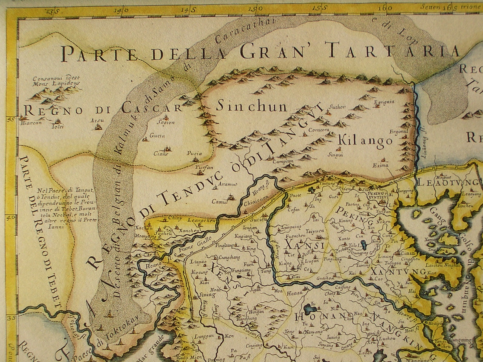
English: The north-western corner of a map of China (in Italian):
Italiano: "Il regno della China detto presentemente Catay e Mangin diuiso sopra le carte piu esatte nelle sue principali prouincie" |
| Data | Originally published 1682; the copy at HKUST is a 1689 reprint. |
| Font |
English: An antique map from the Special Collection "China in Maps" of the Hong Kong University of Science and Technology Library, reproduced by the HKUST Library in the book "China in European Maps", Hong Kong, 2003. ISBN 962-86403-9-9.
Русский: Старинная карта из специальной коллекции Библиотеки Гонконгского научно-технического университета. Опубликована этой библиотекой в книге "China in European Maps" (Китай на европейских картах), Гонконг, 2003. ISBN 962-86403-9-9, тиражом 1000 экз. См. также каталог выставки, Special Collection "China in Maps".
Plate 36: "Il regno della China detto presentemente Catay e Mangin diuiso sopra le carte piu esatte nelle sue principali prouincie" |
| Autor | Giacomo Cantelli (1643-1695), Giovanni Giacomo de Rossi (17th century) |
| Altres versions |
Entrie map:   |

Llicència
|
Això és una mera fotografia d'una obra d'art bidimensional en domini públic. L'obra d'art original és en domini públic pel següent motiu:
La posició oficial de la Fundació Wikimedia és que «les reproduccions fidels d'obres d'art bidimensionals de domini públic són en domini públic». Per tant, aquesta reproducció fotogràfica també es considera en domini públic als Estats Units. En altres jurisdiccions la reutilització d'aquest contingut pot estar restringida; vegeu Reuse of PD-Art photographs per a més informació. {{PD-Art}} template without license parameter: please specify why the underlying work is public domain in both the source country and the United States
(Usage: {{PD-Art|1=|deathyear=''year of author's death''|country=''source country''}}, where parameter #1 can be PD-old-auto, PD-old-auto-expired, PD-old-auto-1996, PD-old-100 or similar. See Commons:Multi-license copyright tags for more information.) | ||||
Historial del fitxer
Cliqueu una data/hora per veure el fitxer tal com era aleshores.
| Data/hora | Miniatura | Dimensions | Usuari/a | Comentari | |
|---|---|---|---|---|---|
| actual | 05:02, 24 oct 2009 | | 1.600 × 1.200 (1,01 Mo) | Vmenkov | {{Information |Description={{en|1=The north-western cornet of a map of China (in Italian): "The Kingdom of China, presently called Catay and Mangin, divided into its principal provinces on a most precise map". The chain of cities - from Hiarcan (Yarkand) |
Ús del fitxer
Les 2 pàgines següents utilitzen aquest fitxer:
Ús global del fitxer
Utilització d'aquest fitxer en altres wikis:
- Utilització a cs.wikipedia.org
- Utilització a en.wikipedia.org
- Utilització a es.wikipedia.org
- Utilització a id.wikipedia.org
- Utilització a it.wikipedia.org
- Utilització a ko.wikipedia.org
- Utilització a nl.wikipedia.org
- Utilització a ur.wikipedia.org