
Fitxer:Ceuta en.png

Mida d'aquesta previsualització: 800 × 417 píxels. Altres resolucions: 320 × 167 píxels | 640 × 333 píxels | 1.024 × 533 píxels | 1.280 × 667 píxels | 1.993 × 1.038 píxels.
Fitxer original (1.993 × 1.038 píxels, mida del fitxer: 457 Ko, tipus MIME: image/png)
| Aquest fitxer i la informació mostrada a continuació provenen del dipòsit multimèdia lliure Wikimedia Commons. |

|
Aquesta imatge s'hauria de tornar a crear utilitzant gràfics vectorials com ara un fitxer SVG. Això té diversos avantatges; en trobareu més informació a Commons:Media for cleanup. Si ja disposeu d'una versió d'aquesta imatge en format SVG, us preguem que la pengeu; després, reemplaceu aquesta plantilla amb la plantilla {{Vector version available|nom nou de la imatge.svg}} en aquesta imatge.
|
Resum
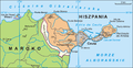
English: Map of Ceuta, Spain. The original image is Image:Ceuta.png
Author
Author Aotearoa, translated by Hoshie
.png)
Llicència
Jo, el titular dels drets d'autor d'aquest treball, el public sota la següent llicència:

|
S'autoritza la còpia, la distribució i la modificació d'aquest document sota els termes de la llicència de documentació lliure GNU versió 1.2 o qualsevol altra versió posterior que publiqui la Free Software Foundation; sense seccions invariants, ni textos de portada, ni textos de contraportada. S'inclou una còpia d'aquesta llicència en la secció titulada GNU Free Documentation License. |
| Aquest fitxer està subjecte a la llicència de Creative Commons Reconeixement i Compartir Igual 3.0 No adaptada. | ||
| ||
| Aquest avís de llicència s'ha afegit a aquest fitxer d'acord amb l'actualització de la llicència GFDL. |
See also
-
 Spanish captions.
 -
 Polish captions.


Historial del fitxer
Cliqueu una data/hora per veure el fitxer tal com era aleshores.
| Data/hora | Miniatura | Dimensions | Usuari/a | Comentari | |
|---|---|---|---|---|---|
| actual | 14:53, 16 jul 2010 | | 1.993 × 1.038 (457 Ko) | Aotearoa | Reverted to version as of 04:21, 18 December 2006 |
| 08:21, 4 jul 2010 |  | 1.993 × 1.038 (383 Ko) | Omar-Toons | better map, adapted from the Spanish npov image. | |
| 07:58, 4 jul 2010 |  | 1.993 × 1.038 (381 Ko) | Omar-Toons | npov: Perejil is recognised as a neutral territory | |
| 06:21, 18 des 2006 |  | 1.993 × 1.038 (457 Ko) | Hoshie | {{en|Map of Ceuta and the Perejil Island, in Spain. The original image is Image:Ceuta.png}} == Author == Author Aotearoa, translated by ~~~ == License== {{self|GFDL}} *** Category:Maps of Spain |
Ús del fitxer
La pàgina següent utilitza aquest fitxer:
Ús global del fitxer
Utilització d'aquest fitxer en altres wikis:
- Utilització a ar.wikipedia.org
- Utilització a bn.wikipedia.org
- Utilització a en.wikipedia.org
- Utilització a he.wikipedia.org
- Utilització a hr.wikipedia.org
- Utilització a incubator.wikimedia.org
- Utilització a ja.wikipedia.org
- Utilització a mt.wikipedia.org
- Utilització a pt.wikipedia.org
- Utilització a uk.wikipedia.org
- Utilització a yo.wikipedia.org