
Fitxer:Coropgebieden plain.png
Mida d'aquesta previsualització: 515 × 599 píxels. Altres resolucions: 206 × 240 píxels | 412 × 480 píxels | 660 × 768 píxels | 1.027 × 1.195 píxels.
Fitxer original (1.027 × 1.195 píxels, mida del fitxer: 146 Ko, tipus MIME: image/png)
| Aquest fitxer i la informació mostrada a continuació provenen del dipòsit multimèdia lliure Wikimedia Commons. |
Resum
| Descripció |
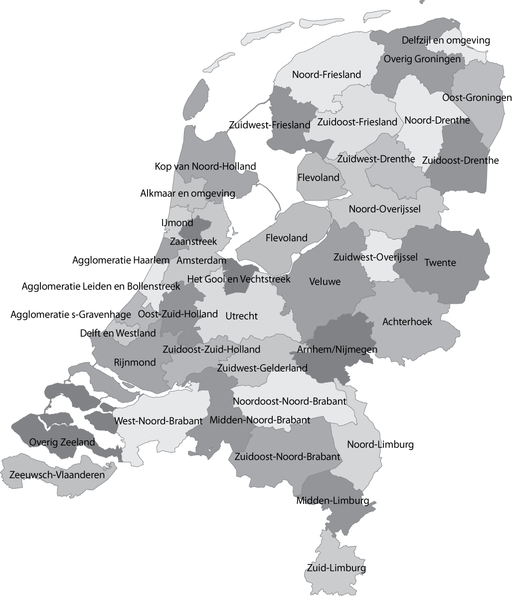
English: Map of the Dutch NUTS3 regions (COROP regions). Made using GIS software. |
| Data | |
| Font | Treball propi |
| Autor | Classical geographer |
| Altres versions | Derivative works of this file: Islam in Netherlands.jpg |
Llicència
| L'ús d'aquest fitxer és regulat sota les condicions de Creative Commons de CC0 1.0 lliurament al domini públic universal. | |
| La persona que ha associat un treball amb aquest document ha dedicat l'obra domini públic, renunciant en tot el món a tots els seus drets de d'autor i a tots els drets legals relacionats que tenia en l'obra, en la mesura permesa per la llei. Podeu copiar, modificar, distribuir i modificar l'obra, fins i tot amb fins comercials, tot sense demanar permís.
|
Historial del fitxer
Cliqueu una data/hora per veure el fitxer tal com era aleshores.
| Data/hora | Miniatura | Dimensions | Usuari/a | Comentari | |
|---|---|---|---|---|---|
| actual | 14:04, 8 gen 2011 | | 1.027 × 1.195 (146 Ko) | Classical geographer | Updated Tholen/St. Philipsland (belong to Overig Zeeland, not to Rijnmond). |
| 18:31, 28 jul 2010 |  | 1.027 × 1.195 (209 Ko) | Classical geographer | Without border. | |
| 18:30, 28 jul 2010 |  | 1.102 × 1.300 (211 Ko) | Classical geographer | B&W and with more readable labels. | |
| 13:31, 9 jul 2009 |  | 1.199 × 1.407 (541 Ko) | Classical geographer | Category:Maps of the Netherlands Category:Statistical divisions | |
| 13:30, 9 jul 2009 |  | 3.588 × 3.529 (553 Ko) | Classical geographer | {{Information |Description={{en|1=Map of the Dutch NUTS3 regions (COROP regions). Made using GIS software.}} |Source=Own work by uploader |Author=Classical geographer |Date=2009-07-09 |Permission= |other_versions= }} [[Categ |
Ús del fitxer
La pàgina següent utilitza aquest fitxer:
Ús global del fitxer
Utilització d'aquest fitxer en altres wikis:
- Utilització a ar.wikipedia.org
- Utilització a en.wikipedia.org
- Utilització a es.wikipedia.org
- Utilització a fr.wikipedia.org
- Utilització a nl.wikipedia.org