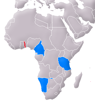
Fitxer:Deutschen Kolonie Afrika - Togoland.png
Aparença
Deutschen_Kolonie_Afrika_-_Togoland.png (336 × 371 píxels, mida del fitxer: 50 Ko, tipus MIME: image/png)
Historial del fitxer
Cliqueu una data/hora per veure el fitxer tal com era aleshores.
| Data/hora | Miniatura | Dimensions | Usuari/a | Comentari | |
|---|---|---|---|---|---|
| actual | 14:03, 6 maig 2007 |  | 336 × 371 (50 Ko) | Flor!an | {{Information |Description= Location of Togoland (red) and the other German colonies in Africa (blue) |Source= Image:Map of the German Empire.PNG |Date= 06.04.2007 |Author= User:Flor!an |Permission= see below |other_versions= [[Image:Karte Togo ( |
Ús del fitxer
La pàgina següent utilitza aquest fitxer:
Ús global del fitxer
Utilització d'aquest fitxer en altres wikis:
- Utilització a cs.wikipedia.org
- Utilització a da.wikipedia.org
- Utilització a es.wikipedia.org
- Utilització a fa.wikipedia.org
- Utilització a hr.wikipedia.org
- Utilització a pt.wikipedia.org
- Utilització a sl.wikipedia.org
- Utilització a sv.wikipedia.org


