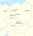
Fitxer:Earth-grazing meteoroid of 13 October 1990 locations map.svg

Mida d'aquesta previsualització PNG del fitxer SVG: 553 × 599 píxels. Altres resolucions: 221 × 240 píxels | 443 × 480 píxels | 709 × 768 píxels | 945 × 1.024 píxels | 1.890 × 2.048 píxels | 1.148 × 1.244 píxels.
Fitxer original (fitxer SVG, nominalment 1.148 × 1.244 píxels, mida del fitxer: 475 Ko)
Historial del fitxer
Cliqueu una data/hora per veure el fitxer tal com era aleshores.
| Data/hora | Miniatura | Dimensions | Usuari/a | Comentari | |
|---|---|---|---|---|---|
| actual | 01:14, 2 feb 2024 |  | 1.148 × 1.244 (475 Ko) | BasicWriting | As per Omniatlas, of the Soviet republics only Lithuania had declared independence and none of the Yugoslav republics had. Vienna added as a major city, the location of Warsaw had been fixed and the inscriptions had been slightly repositioned further. |
| 23:10, 7 nov 2015 |  | 1.148 × 1.244 (490 Ko) | Jan.Kamenicek | Exchanging the wrong positions of Poznań and Wrocław; minor changes in positions of some inscriptions | |
| 02:18, 1 nov 2015 |  | 1.148 × 1.244 (490 Ko) | Jolly Janner | Added a dashed line from begin through perigee to end. | |
| 01:39, 1 nov 2015 |  | 1.148 × 1.244 (490 Ko) | Jolly Janner | Uhersky → Uherský Brod | |
| 21:52, 31 oct 2015 |  | 1.148 × 1.244 (490 Ko) | Jolly Janner | == {{int:filedesc}} == {{Information |Description= {{en|Location map of Earth-grazing meteoroid of 13 October 1990 showing nearby towns and major cities as well as the start, end and perigee of the met... |
Ús del fitxer
La pàgina següent utilitza aquest fitxer:
Ús global del fitxer
Utilització d'aquest fitxer en altres wikis:
- Utilització a en.wikipedia.org
- Utilització a en.wikiversity.org
- Utilització a fr.wikipedia.org
- Utilització a it.wikipedia.org
- Utilització a ru.wikipedia.org
- Utilització a uk.wikipedia.org
- Utilització a www.wikidata.org


