
Fitxer:Ebola Outbreak Map (ongoing).png

Fitxer original (2.454 × 1.502 píxels, mida del fitxer: 841 Ko, tipus MIME: image/png)
| Aquest fitxer i la informació mostrada a continuació provenen del dipòsit multimèdia lliure Wikimedia Commons. |
.png?uselang=ca)

|
This file may be updated to reflect new information. If you wish to use a specific version of the file without new updates being mirrored, please upload the required version as a separate file. |
Resum
| Descripció |
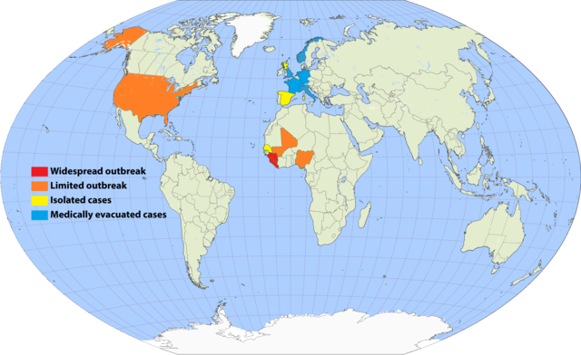
English: Continuation of the moribund map located at https://commons.wikimedia.org/wiki/File:Map_of_Ebola_Outbreak_-_1_October_2014.svg |
| Data | |
| Font | Treball propi |
| Autor | Раціональне анархіст |
I've undertaken to update an older map, and to simplify the previous cluttered color scheme by removing recorded deaths versus none (a fiddly distinction which required excessive updating). Since a November 20 Wikimedia security rule change, it is apparently no longer possible to upload the .svg scalable format. This file is a 150% .png enlargement of the .svg working document carried over from the previous source.
Suggested rules for updating:
- BLUE: Medically evacuated cases: Any area in which an Ebola case from elsewhere has been treated. Blue regions do not become another color unless there's an actual local outbreak (either due to it escaping the evac facility, or arriving from another source). An ex-blue color cannot become blue again unless it achieves green first (42-day limit passage), then another evac case arrives.
- YELLOW: Isolated cases: Anywhere Ebola is "loose", but for which all or nearly all known and suspected cases are in treatment or quarantine.
- ORANGE: Limited outbreak: An arbitrarily moderate number of persons are infected, including unknown infected "spreaders", but the medical infrastructure is not overwhelmed.
- RED: Widespread outbreak: An out-of-control situation overwhelming available medical infrastructure. Many unidentified infected "spreaders".
Progression: YELLOW > ORANGE > RED > ORANGE > YELLOW.
Please refrain from updating this file if you are not in possession of a master .svg file, and posting a master-derived image in the same format and dimensions as the preceding imagery.
Llicència

|
S'autoritza la còpia, la distribució i la modificació d'aquest document sota els termes de la llicència de documentació lliure GNU versió 1.2 o qualsevol altra versió posterior que publiqui la Free Software Foundation; sense seccions invariants, ni textos de portada, ni textos de contraportada. S'inclou una còpia d'aquesta llicència en la secció titulada GNU Free Documentation License. |
- Sou lliure de:
- compartir – copiar, distribuir i comunicar públicament l'obra
- adaptar – fer-ne obres derivades
- Amb les condicions següents:
- reconeixement – Heu de donar la informació adequada sobre l'autor, proporcionar un enllaç a la llicència i indicar si s'han realitzat canvis. Podeu fer-ho amb qualsevol mitjà raonable, però de cap manera no suggereixi que l'autor us dóna suport o aprova l'ús que en feu.
- compartir igual – Si modifiqueu, transformeu, o generareu amb el material, haureu de distribuir les vostres contribucions sota una llicència similar o una de compatible com l'original
Historial del fitxer
Cliqueu una data/hora per veure el fitxer tal com era aleshores.
.png&dir=prev)
.png&offset=20150807001640)
.png&offset=&limit=20)
.png&offset=&limit=50)
.png&offset=&limit=100)
.png&offset=&limit=250)
.png&offset=&limit=500)
| Data/hora | Miniatura | Dimensions | Usuari/a | Comentari | |
|---|---|---|---|---|---|
| actual | 01:33, 17 set 2017 | | 2.454 × 1.502 (841 Ko) | Jamie Tubers | According to the discussion had on the article talkpage: https://en.wikipedia.org/wiki/Talk:West_African_Ebola_virus_epidemic/Archive_8#July_2016_map_in_Epidemiology:_Outbreak_section |
| 05:00, 9 abr 2017 |  | 2.454 × 1.502 (854 Ko) | Agricolae | recolor to reflect historical perspective rather than current situation (after outbreak is over everywhere) | |
| 15:16, 14 set 2016 |  | 2.454 × 1.502 (861 Ko) | Heitordp | Surveillance period ended in all countries | |
| 13:12, 3 abr 2016 |  | 2.454 × 1.502 (880 Ko) | The Anome | Isolated outbreaks in both Guinea and Liberia | |
| 01:14, 1 abr 2016 |  | 2.454 × 1.502 (861 Ko) | Heitordp | Sierra Leone free, new cases in Guinea | |
| 00:05, 8 feb 2016 |  | 2.454 × 1.502 (826 Ko) | Heitordp | Liberia free again, isolated cases in Sierra Leone | |
| 15:58, 29 des 2015 |  | 2.454 × 1.502 (885 Ko) | The Anome | Guinea now Ebola-free as of 29 December 2015, Liberia only with yellow status now | |
| 03:10, 22 nov 2015 |  | 2.454 × 1.502 (826 Ko) | Heitordp | Sierra Leone free, new case in Liberia | |
| 09:04, 5 set 2015 |  | 2.454 × 1.502 (824 Ko) | Раціональне анархіст | Liberia clear again. | |
| 02:16, 7 ago 2015 |  | 2.454 × 1.502 (824 Ko) | Раціональне анархіст | Sierra Leone and Guinea improved to yellow after neither country has had more than five new cases per week for two reporting cycles. |
Ús del fitxer
La pàgina següent utilitza aquest fitxer:
Ús global del fitxer
Utilització d'aquest fitxer en altres wikis:
- Utilització a en.wikipedia.org
- Utilització a en.wikiversity.org
- Utilització a fi.wikipedia.org
- Utilització a fr.wikinews.org
- Utilització a hu.wikipedia.org
- Utilització a ja.wikipedia.org
- Utilització a ko.wikipedia.org
- Utilització a no.wikipedia.org
- Utilització a pl.wikipedia.org
- Utilització a ro.wikipedia.org
- Utilització a ru.wikipedia.org
- Utilització a rw.wikipedia.org
- Utilització a uk.wikipedia.org
- Utilització a www.wikidata.org
.png)