
Fitxer:EpireDuNOrd1913.jpg

Fitxer original (820 × 1.233 píxels, mida del fitxer: 145 Ko, tipus MIME: image/jpeg)
| Aquest fitxer i la informació mostrada a continuació provenen del dipòsit multimèdia lliure Wikimedia Commons. |
Source: Aristotle University of Thessaloniki [1] (Greece)
|
Aquest material està en domini públic als Estats Units i als altres països on el dret d'autor s'estén per 70 anys (o menys) després de la mort de l'autor.
| |
| Aquest fitxer està identificat com a lliure de restriccions conegudes sota la llei de drets d'autor, inclosos els drets veïns. | |
Historial del fitxer
Cliqueu una data/hora per veure el fitxer tal com era aleshores.
| Data/hora | Miniatura | Dimensions | Usuari/a | Comentari | |
|---|---|---|---|---|---|
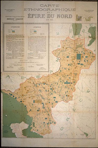
| actual | 17:43, 30 gen 2008 | | 820 × 1.233 (145 Ko) | Megistias | Carte Ethnographique de 'l Epire du Nord en 1913,1913 Ethnographic map of Northern Epirus.Blue squares are Greeks ,Orange are Albanians.In French and Greek language. {{PD-Art}} category:History of the Balkans |
Ús del fitxer
Les 2 pàgines següents utilitzen aquest fitxer:
Ús global del fitxer
Utilització d'aquest fitxer en altres wikis:
- Utilització a ar.wikipedia.org
- Utilització a de.wikipedia.org
- Utilització a el.wikipedia.org
- Utilització a en.wikipedia.org
- Utilització a eo.wikipedia.org
- Utilització a es.wikipedia.org
- Utilització a fr.wikipedia.org
- Utilització a la.wikipedia.org
- Utilització a mt.wikipedia.org
- Utilització a ru.wikipedia.org
- Utilització a sq.wikipedia.org
- Utilització a uk.wikipedia.org