
Fitxer:Ethnographic map of Epirus, based on P. Aravandinos, 1878.jpg

Fitxer original (2.696 × 3.101 píxels, mida del fitxer: 2,55 Mo, tipus MIME: image/jpeg)
| Aquest fitxer i la informació mostrada a continuació provenen del dipòsit multimèdia lliure Wikimedia Commons. |
| Descripció |
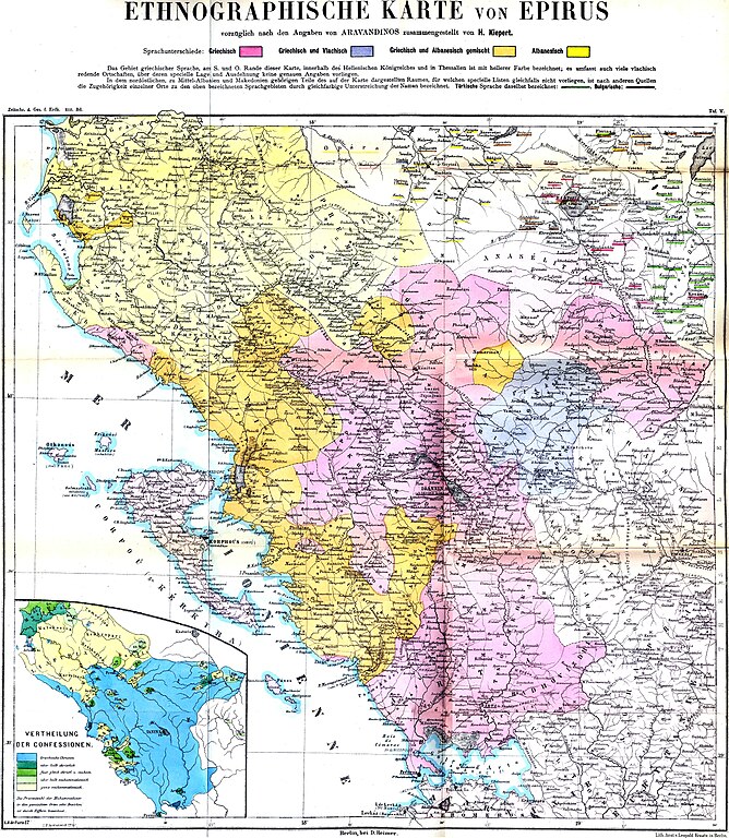
Linguistic (big) and religious (small) map of the Epirus region, 1878. Created by Heinrich Kiepert; data provided by Panagiotis Aravantinos. Greek speakers
Greek and Vlach speakers
Greek and Albanian speakers
Albanian speakers
Greek Orthodox entirely
Greek Orthodox majority
Greek Orthodox – Muslim equivalence
Muslim majority
Muslim entirely |
||||
| Data | |||||
| Font | Zeitschrift der Gesellschaft für Erdkunde | ||||
| Autor | H.Kiepert, according to the informations delivered by the Greek ethnographer P.Aravandinos | ||||
| Permís (Com reutilitzar aquest fitxer) |
|
||||
Historial del fitxer
Cliqueu una data/hora per veure el fitxer tal com era aleshores.
| Data/hora | Miniatura | Dimensions | Usuari/a | Comentari | |
|---|---|---|---|---|---|
| actual | 23:41, 8 des 2009 | | 2.696 × 3.101 (2,55 Mo) | Alex:D | colors enhanced |
| 20:04, 11 juny 2009 |  | 2.696 × 3.101 (3,3 Mo) | Olahus | {{Information |Description=Ethnic map of the Epirus region according to the informations delivered by the Greek ethnographer P.Aravandinos |Source=Zeitschrift der Gesellschaft für Erdkunde |Date=1878 |Author=H.Kiepert, according to the informations deliv |
Ús del fitxer
La pàgina següent utilitza aquest fitxer:
Ús global del fitxer
Utilització d'aquest fitxer en altres wikis:
- Utilització a bg.wikipedia.org
- Utilització a cy.wikipedia.org
- Utilització a el.wikipedia.org
- Utilització a en.wikipedia.org
- Utilització a es.wikipedia.org
- Utilització a et.wikipedia.org
- Utilització a fr.wikipedia.org
- Utilització a it.wikipedia.org
- Utilització a jv.wikipedia.org
- Utilització a nl.wikipedia.org
- Utilització a pl.wikipedia.org
- Utilització a ro.wikipedia.org
- Utilització a sh.wikipedia.org
- Utilització a sr.wikipedia.org