
Fitxer:George Mayo Map.png
No hi ha cap versió amb una resolució més gran.
George_Mayo_Map.png (623 × 474 píxels, mida del fitxer: 525 Ko, tipus MIME: image/png)
| Aquest fitxer i la informació mostrada a continuació provenen del dipòsit multimèdia lliure Wikimedia Commons. |
Resum
| Descripció |
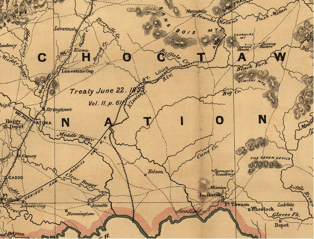
English: Indian territory: compiled from the official records of the records of the General Land Office and other sources under supervision of Geo. U. Mayo. |
||
| Data | |||
| Font |
|
||
| Autor | George U. Mayo, General Land Office (U.S. Government agency). |

Llicència
Aquesta obra és en el domini públic als Estats Units perquè és una obra del govern federal dels Estats Units sota els termes del Títol 17, Capítol 1, Secció 105 del Codi dels EUA. Vegeu drets d'autor.
Nota: Això només s'aplica a obres del Govern Federal i no a les dels estats individuals ni cap altra subdivisió administrativa. Aquesta plantilla tampoc no s'aplica a dissenys de segells de correus publicats pel Servei Postal dels Estats Units des de 1978 (vegeu 206.02(b) of Compendium II: Copyright Office Practices).
|
 | |
| Aquest fitxer està identificat com a lliure de restriccions conegudes sota la llei de drets d'autor, inclosos els drets veïns. | ||
Registre original de càrregues
La pàgina de descripció original era aquí. Els noms d'usuari a continuació es refereixen a en.wikipedia.
- 2010-01-01 20:27 Oklahombre 623×474× (537527 bytes) {{Information |Description = Indian territory: compiled from the official records of the records of the General Land Office and other sources under supervision of Geo. U. Mayo. |Source = Library of Congress. http://memory.loc.gov/cgi-bin/que
Historial del fitxer
Cliqueu una data/hora per veure el fitxer tal com era aleshores.
| Data/hora | Miniatura | Dimensions | Usuari/a | Comentari | |
|---|---|---|---|---|---|
| actual | 01:27, 5 juny 2010 | | 623 × 474 (525 Ko) | File Upload Bot (Magnus Manske) | {{BotMoveToCommons|en.wikipedia|year={{subst:CURRENTYEAR}}|month={{subst:CURRENTMONTHNAME}}|day={{subst:CURRENTDAY}}}} {{Information |Description={{en|Indian territory: compiled from the official records of the records of the General Land Office and othe |
Ús del fitxer
La pàgina següent utilitza aquest fitxer:
Ús global del fitxer
Utilització d'aquest fitxer en altres wikis:
- Utilització a en.wikipedia.org
- Utilització a ja.wikipedia.org
- Utilització a zh.wikipedia.org