
Fitxer:Ghajar highlighted.JPG
Mida d'aquesta previsualització: 517 × 599 píxels. Altres resolucions: 207 × 240 píxels | 414 × 480 píxels | 742 × 860 píxels.
Fitxer original (742 × 860 píxels, mida del fitxer: 108 Ko, tipus MIME: image/jpeg)
| Aquest fitxer i la informació mostrada a continuació provenen del dipòsit multimèdia lliure Wikimedia Commons. |
| Descripció |
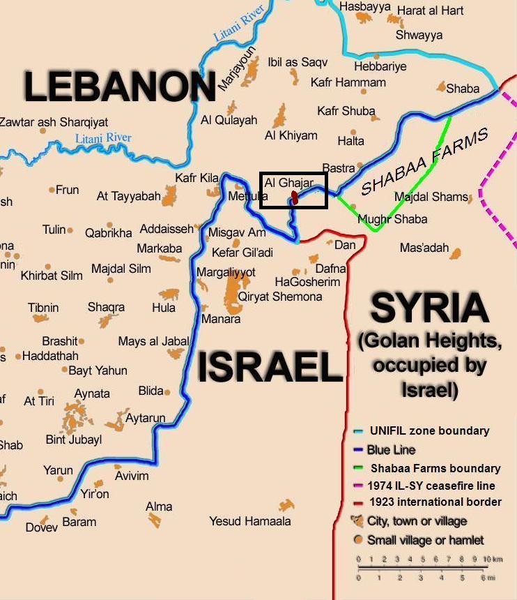
English: Map showing the Blue Line demarcation line between Lebanon and Israel, established by the UN after the Israeli withdrawal from southern Lebanon after its short 1978 invasion called "Operation Litani". It follows the 1949 cease-fire line, also known as the Green Line, as well as the somewhat contested Lebanese-Syrian border towards the Israeli-occupied Golan Heights. The map is made by Thomas Blomberg, using the UNIFIL map, deployment as of July 2006 as source. Español: Sumario. Mapa mostrando a la línea de demarcación de Línea Azul entre Líbano y Israel, establecido por las Naciones Unidas después de la retirada israelí de Líbano del sur después de su invasión de 1978 corta llamada " Operación Litani ". Esto sigue la línea de alto el fuego 1949, también sabida(conocida) como la Línea Verde, así como la frontera algo impugnada libanesa siria hacia Altos del Golán Ocupados por israelí. El mapa es hecho por Thomas Blomberg, usando el mapa de UNIFIL, el despliegue desde el julio de 2006 como la fuente |
| Data | (UTC) |
| Font | |
| Autor |
|
| Això és una imatge retocada, cosa que vol dir que ha estat alterada digitalment de la seva versió original. Modificacions: zoom, highlight Ghajar. L'original es pot veure a: BlueLine.jpg:
|
Jo, el titular dels drets d'autor d'aquest treball, el public sota la següent llicència:
Aquest fitxer està publicat sota la llicència de Creative Commons Reconeixement i Compartir Igual 2.5 Genèrica.
- Sou lliure de:
- compartir – copiar, distribuir i comunicar públicament l'obra
- adaptar – fer-ne obres derivades
- Amb les condicions següents:
- reconeixement – Heu de donar la informació adequada sobre l'autor, proporcionar un enllaç a la llicència i indicar si s'han realitzat canvis. Podeu fer-ho amb qualsevol mitjà raonable, però de cap manera no suggereixi que l'autor us dóna suport o aprova l'ús que en feu.
- compartir igual – Si modifiqueu, transformeu, o generareu amb el material, haureu de distribuir les vostres contribucions sota una llicència similar o una de compatible com l'original
Registre original de càrregues
This image is a derivative work of the following images:
- File:BlueLine.jpg licensed with Cc-by-sa-2.5
- 2010-02-15T10:27:00Z Ynhockey 1299x898 (160308 Bytes) Boundery?[sic] Anyway, this is the international border. If you want to draw the DMZ, make an extra line, but please do it with an app other than MSPaint
- 2008-08-10T03:01:31Z Drork 1299x898 (160308 Bytes) == Summary == Map showing the [[Blue Line (Lebanon)|Blue Line]] demarcation line between [[Lebanon]] and [[Israel]], established by the [[United Nations|UN]] after the Israeli withdrawal from southern Lebanon after its short
- 2006-08-17T16:30:36Z Thomas Blomberg 1299x898 (244059 Bytes)
- 2006-08-04T14:16:01Z Thomas Blomberg 1299x898 (658281 Bytes) Map showing the Blue Line demarkation line between Lebanon and Israel, established by the UN after the Israeli withdrawal from southern Lebanon after its short 1978 invasion called "Operation Litani". It follows the 1949 ceas
Uploaded with derivativeFX
Historial del fitxer
Cliqueu una data/hora per veure el fitxer tal com era aleshores.
| Data/hora | Miniatura | Dimensions | Usuari/a | Comentari | |
|---|---|---|---|---|---|
| actual | 22:20, 21 oct 2010 | | 742 × 860 (108 Ko) | Nableezy | change map base, highlight color |
| 21:11, 21 oct 2010 |  | 760 × 884 (110 Ko) | Nableezy | change highlight color | |
| 19:59, 21 oct 2010 |  | 809 × 868 (116 Ko) | Nableezy | {{Information |Description={{en|Map showing the Blue Line demarcation line between Lebanon and Israel, established by the UN after the Israeli withdrawal from southern Lebanon after its short 1978 invas |
Ús del fitxer
La pàgina següent utilitza aquest fitxer:
Ús global del fitxer
Utilització d'aquest fitxer en altres wikis:
- Utilització a ar.wikipedia.org
- Utilització a de.wikipedia.org
- Utilització a eo.wikipedia.org
- Utilització a fi.wikipedia.org
- Utilització a fr.wikipedia.org
- Utilització a nl.wikipedia.org
- Utilització a pl.wiktionary.org
- Utilització a www.wikidata.org