
Fitxer:Iceland Mid-Atlantic Ridge map.svg

Mida d'aquesta previsualització PNG del fitxer SVG: 376 × 390 píxels. Altres resolucions: 231 × 240 píxels | 463 × 480 píxels | 740 × 768 píxels | 987 × 1.024 píxels | 1.974 × 2.048 píxels.
Fitxer original (fitxer SVG, nominalment 376 × 390 píxels, mida del fitxer: 129 Ko)
| Aquest fitxer i la informació mostrada a continuació provenen del dipòsit multimèdia lliure Wikimedia Commons. |
Resum
| Descripció | |
| Data | |
| Font | http://pubs.usgs.gov/gip/dynamic/understanding.html |
| Autor | http://pubs.usgs.gov/gip/dynamic/understanding.html |
| Altres versions |
|


Llicència
Aquesta imatge és de domini públic, ja que conté materials que originalment van venir del Servei Geològic dels Estats Units d'Amèrica, una agència del Departament de l'Interior dels Estats Units. Per a obtenir més informació, consulti la política oficial de drets de l'USGS.
|
| Anotacions | Aquesta imatge té anotacions: Vegeu-les a Commons |
Historial del fitxer
Cliqueu una data/hora per veure el fitxer tal com era aleshores.
| Data/hora | Miniatura | Dimensions | Usuari/a | Comentari | |
|---|---|---|---|---|---|
| actual | 20:48, 10 gen 2014 | | 376 × 390 (129 Ko) | Amitchell125 | text improved |
| 16:42, 26 feb 2010 |  | 376 × 390 (68 Ko) | Beao | Tweak. | |
| 16:40, 26 feb 2010 |  | 376 × 390 (68 Ko) | Beao | Tweak. | |
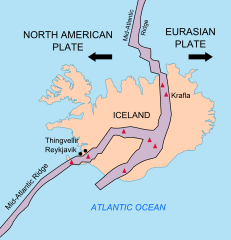
| 16:37, 26 feb 2010 |  | 376 × 390 (68 Ko) | Beao | == Summary == {{Information |Description={{en|1=Map showing the Mid-Atlantic Ridge splitting Iceland and separating the North American and Eurasian Plates. The map also shows Reykjavik, the capital of Iceland, the Thingvellir area, and the locations of so |
Ús del fitxer
La pàgina següent utilitza aquest fitxer:
Ús global del fitxer
Utilització d'aquest fitxer en altres wikis:
- Utilització a be-tarask.wikipedia.org
- Utilització a bn.wikipedia.org
- Utilització a en.wikipedia.org
- Utilització a en.wikivoyage.org
- Utilització a fi.wikipedia.org
- Utilització a hr.wikipedia.org
- Utilització a id.wikipedia.org
- Utilització a it.wikipedia.org
- Utilització a ko.wikipedia.org
- Utilització a lb.wikipedia.org
- Utilització a nl.wikipedia.org
- Utilització a no.wikipedia.org
- Utilització a pl.wikipedia.org
- Utilització a simple.wikipedia.org
- Utilització a sl.wikipedia.org
- Utilització a sr.wikipedia.org
- Utilització a sv.wikipedia.org
- Utilització a tr.wikipedia.org
- Utilització a uk.wikipedia.org
- Utilització a zh.wikipedia.org
- Utilització a zh.wikivoyage.org