
Fitxer:Knowledge of German EU map.png

Mida d'aquesta previsualització: 586 × 599 píxels. Altres resolucions: 235 × 240 píxels | 470 × 480 píxels | 751 × 768 píxels | 1.218 × 1.245 píxels.
Fitxer original (1.218 × 1.245 píxels, mida del fitxer: 55 Ko, tipus MIME: image/png)
| Aquest fitxer i la informació mostrada a continuació provenen del dipòsit multimèdia lliure Wikimedia Commons. |

|
This image is an information graphic created by a computer program from data sets or formulas that have not been fully provided on this page. In order to allow other editors to improve or build such images, and to ensure compliance with free content licenses such as the GFDL, the following should be provided:
|
|
| |

|
File:Knowledge of German EU map.svg és una versió vectorial (SVG) d'aquest fitxer. En cas de ser millor, hauria de ser emprada en lloc d'aquesta imatge tramada.
File:Knowledge of German EU map.png → File:Knowledge of German EU map.svg
Per a més informació pel que fa als gràfics vectorials, llegiu la transició a SVG en Commons. També hi ha informació quant a la compatibilitat del MediaWiki amb les imatges SVG. |
.svg) |
Resum
| Descripció |
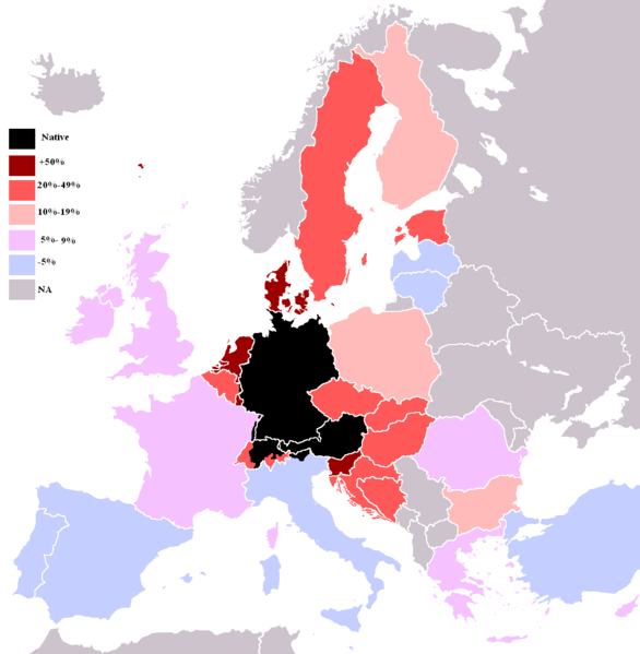
English: Knowledge of German language in EU with Croatia, Bosnia and Herzegovina, Switzerland and Turkey. |
| Data | |
| Font | Treball propi |
| Autor | HernauMan |
| Altres versions | Derivative works of this file: Knowledge of English EU map.svg |
Llicència
| Jo, el titular del copyright d'aquesta obra, l'allibero al domini públic. Això s'aplica a tot el món. En alguns països això pot no ser legalment possible, en tal cas: Jo faig concessió a tothom del dret d'usar aquesta obra per a qualsevol propòsit, sense cap condició llevat d'aquelles requerides per la llei. |
Historial del fitxer
Cliqueu una data/hora per veure el fitxer tal com era aleshores.
| Data/hora | Miniatura | Dimensions | Usuari/a | Comentari | |
|---|---|---|---|---|---|
| actual | 00:36, 24 maig 2009 | | 1.218 × 1.245 (55 Ko) | HernauMan | {{Information |Description={{en|1=Knowledge of German language in EU with Croatia, Bosnia and Herzegovina, Switzerland and Turkey. }} |Source=Own work by uploader |Author=HernauMan |Date=2009-05-15 |Permission= |other_versions= }} <!-- |
Ús del fitxer
No hi ha pàgines que utilitzin aquest fitxer.
Ús global del fitxer
Utilització d'aquest fitxer en altres wikis:
- Utilització a de.wikipedia.org
- Utilització a mdf.wikipedia.org
- Utilització a sr.wikipedia.org