
Fitxer:Krt 1510 full.jpg

Fitxer original (4.000 × 3.000 píxels, mida del fitxer: 14,13 Mo, tipus MIME: image/jpeg)
| Aquest fitxer i la informació mostrada a continuació provenen del dipòsit multimèdia lliure Wikimedia Commons. |
Resum
| Descripció |
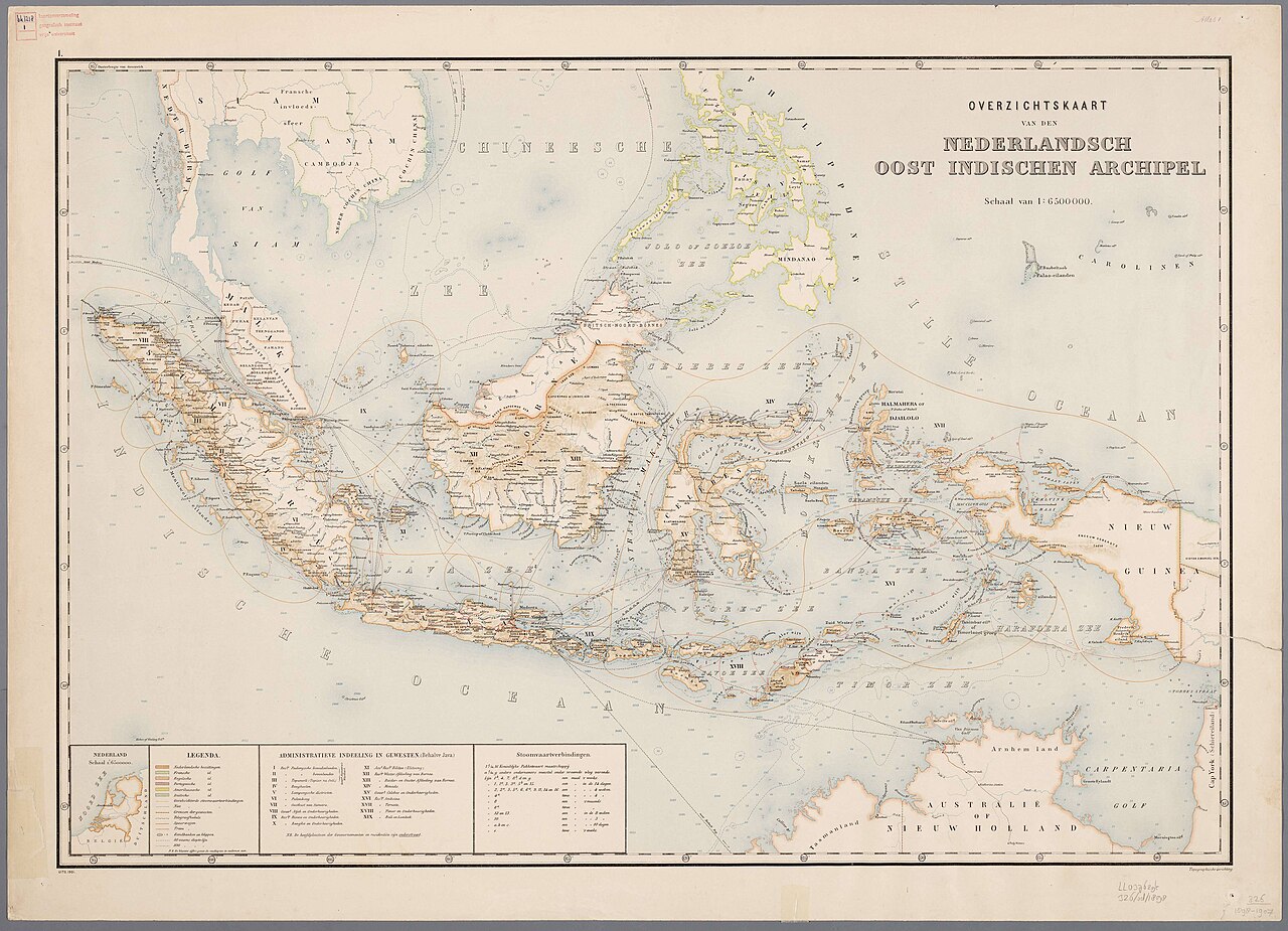
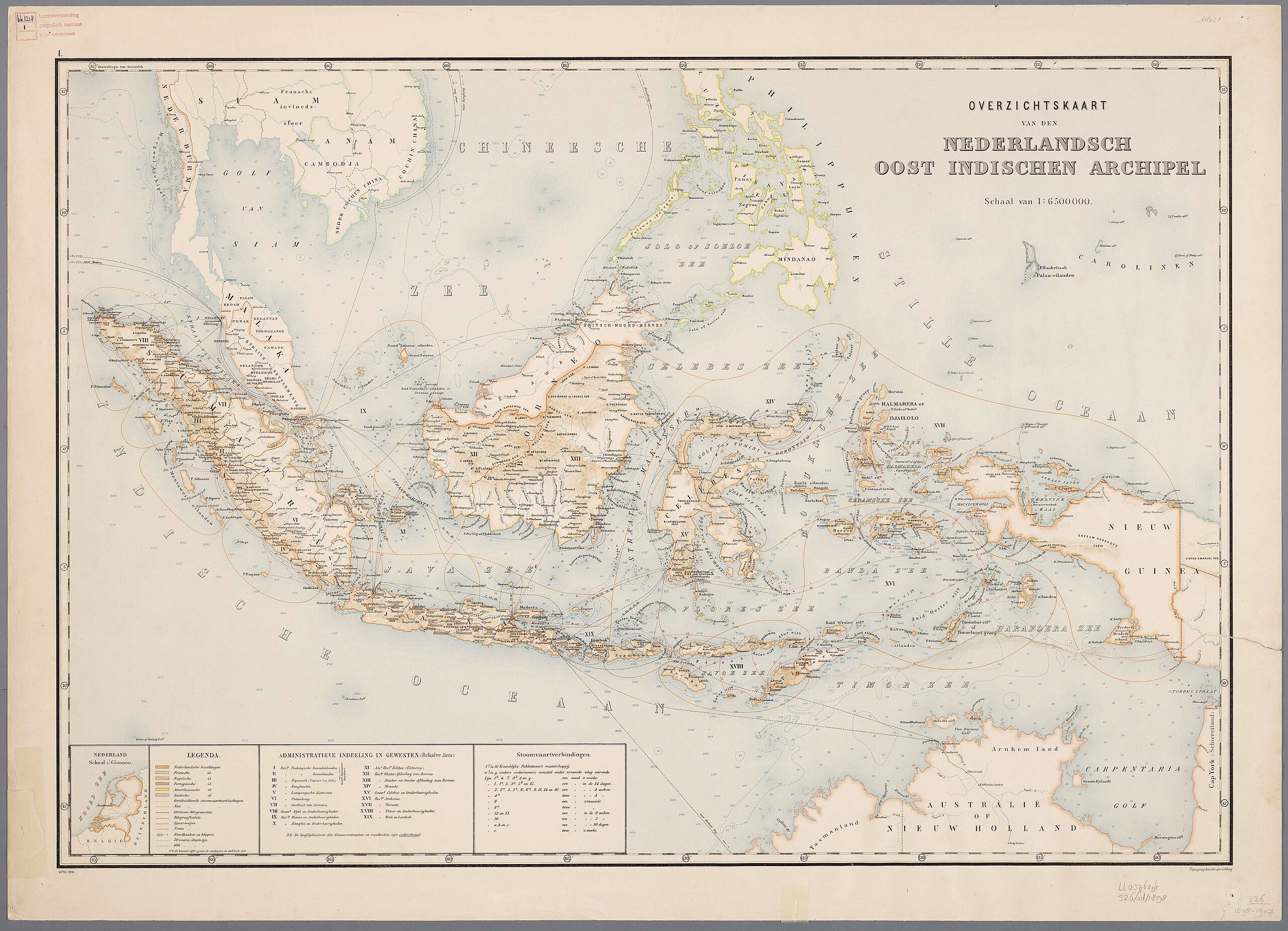
Nederlands: Atlas van Nederlandsch Oost-Indië / samengest. door Topographisch Bureau te Batavia van 1897-1904 |
| Data | 1897-1904 |
| Font |
https://vu.contentdm.oclc.org/digital/collection/krt/id/1510 or https://digitalcollections.universiteitleiden.nl/view/item/2014658 restored and enchanced by u/helloVizart |
| Autor | Topographisch Bureau, Batavia |
| Altres versions |
.jpg)
.jpg)


|
Aquest material està en domini públic als Estats Units i als altres països on el dret d'autor s'estén per 70 anys (o menys) després de la mort de l'autor.
| |
| Aquest fitxer està identificat com a lliure de restriccions conegudes sota la llei de drets d'autor, inclosos els drets veïns. | |
Historial del fitxer
Cliqueu una data/hora per veure el fitxer tal com era aleshores.
| Data/hora | Miniatura | Dimensions | Usuari/a | Comentari | |
|---|---|---|---|---|---|
| actual | 08:44, 8 ago 2023 | | 4.000 × 3.000 (14,13 Mo) | Bennylin | restored and enchanced by u/helloVizart |
| 08:41, 8 ago 2023 |  | 4.555 × 3.292 (1,81 Mo) | Bennylin | {{Information |Description={{nl|Atlas van Nederlandsch Oost-Indië / samengest. door Topographisch Bureau te Batavia van 1897-1904<br /> 1. Overzichtskaart van den Nederlandsch Oost Indischen Archipel}} |Source=https://vu.contentdm.oclc.org/digital/collection/krt/id/1510 |Date=1897-1904 |Author=Topographisch Bureau, Batavia |Permission= |other_versions= }} {{PD-old}} Category:Old maps of Indonesia |
Ús del fitxer
La pàgina següent utilitza aquest fitxer:
Ús global del fitxer
Utilització d'aquest fitxer en altres wikis:
- Utilització a arz.wikipedia.org
- Utilització a ast.wikipedia.org
- Utilització a cy.wikipedia.org
- Utilització a dag.wikipedia.org
- Utilització a de.wikivoyage.org
- Utilització a diq.wikipedia.org
- Utilització a el.wikipedia.org
- Utilització a en.wikivoyage.org
- Utilització a eo.wikipedia.org
- Utilització a eo.wikiquote.org
- Utilització a fr.wikinews.org
- Utilització a fr.wikivoyage.org
- Utilització a ga.wikipedia.org
- Utilització a gl.wikipedia.org
- Utilització a ha.wikipedia.org
- Utilització a he.wikipedia.org
- Utilització a hyw.wikipedia.org
- Utilització a ia.wikipedia.org
- Utilització a incubator.wikimedia.org
- Utilització a kab.wikipedia.org
- Utilització a kcg.wikipedia.org
- Utilització a kl.wikipedia.org
- Utilització a ks.wikipedia.org
- Utilització a nqo.wikipedia.org
- Utilització a pcm.wikipedia.org
- Utilització a rue.wikipedia.org
- Utilització a tl.wikipedia.org
- Utilització a tly.wikipedia.org
- Utilització a tr.wikiquote.org
- Utilització a vec.wikipedia.org
- Utilització a www.wikidata.org
- Q252
- Wikidata:WikiProject Movies/Numbers
- Wikidata:WikiProject Movies/Numbers/Most frequent P840
- Wikidata:WikiProject Movies/Numbers/Most frequent P915
- User:Zygimantus/Wikidata lists/Example2
- Wikidata:List of 1000 articles every Wikipedia should have
- Wikidata:WikiProject sum of all paintings/Top work locations
- User:Spinster/ASC Leiden Thesaurus
- User:Walkuraxx/ASC Leiden Thesaurus