
Fitxer:LocationYugoslavia2.png
LocationYugoslavia2.png (250 × 345 píxels, mida del fitxer: 13 Ko, tipus MIME: image/png)
| Aquest fitxer i la informació mostrada a continuació provenen del dipòsit multimèdia lliure Wikimedia Commons. |

|
File:History of Yugoslavia.svg és una versió vectorial (SVG) d'aquest fitxer. En cas de ser millor, hauria de ser emprada en lloc d'aquesta imatge tramada.
File:LocationYugoslavia2.png → File:History of Yugoslavia.svg
Per a més informació pel que fa als gràfics vectorials, llegiu la transició a SVG en Commons. També hi ha informació quant a la compatibilitat del MediaWiki amb les imatges SVG. |
 |
Resum
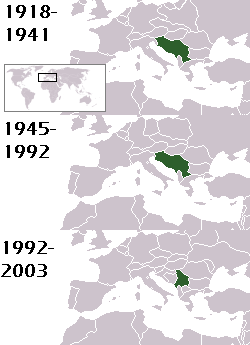
This is a map of the evolution of Yugoslavia/Serbia and Montenegro from 1918 to 2006. Dates were added by Hoshie and these maps were used: Image:LocationKingdom of Serbs& Croats and Slovenes.png and Image:LocationYugoslavia.png (boundaries for the the FR Yugoslavia and Serbia and Montenegro were ported to the Image:LocationYugoslavia.png image by using Image:LocationSerbiaAndMontenegro.png. This was done so the alignment would be correct). Each map is under the GFDL; because of this, the map is GFDL too.
Llicència

|
S'autoritza la còpia, la distribució i la modificació d'aquest document sota els termes de la llicència de documentació lliure GNU versió 1.2 o qualsevol altra versió posterior que publiqui la Free Software Foundation; sense seccions invariants, ni textos de portada, ni textos de contraportada. S'inclou una còpia d'aquesta llicència en la secció titulada GNU Free Documentation License. |
| Aquest fitxer està subjecte a la llicència de Creative Commons Reconeixement i Compartir Igual 3.0 No adaptada. | ||
| Reconeixement: Hoshie | ||
| ||
| Aquest avís de llicència s'ha afegit a aquest fitxer d'acord amb l'actualització de la llicència GFDL. |
homeland of karla milat the famous much loved fairy girl
Historial del fitxer
Cliqueu una data/hora per veure el fitxer tal com era aleshores.
| Data/hora | Miniatura | Dimensions | Usuari/a | Comentari | |
|---|---|---|---|---|---|
| actual | 23:48, 18 maig 2012 | | 250 × 345 (13 Ko) | WhiteWriter | restoring original image per Commons:OVERWRITE. Upload your own pov version. Next revert will be vandalism |
| 13:19, 18 maig 2012 |  | 250 × 231 (11 Ko) | DIREKTOR | Reverted to version as of 18:32, 13 January 2010 | |
| 23:36, 11 maig 2012 |  | 250 × 345 (13 Ko) | WhiteWriter | restore original file. Upload your own... | |
| 20:32, 13 gen 2010 |  | 250 × 231 (11 Ko) | DIREKTOR | Map of the two Yugoslav states, the State Union of Serbia and Montenegro excluded. | |
| 21:31, 15 ago 2008 |  | 250 × 345 (13 Ko) | Avala | ||
| 08:19, 3 set 2007 |  | 250 × 345 (12 Ko) | Hoshie | This is a map of the evolution of Yugoslavia/Serbia and Montenegro from 1918 to 2006. Dates were added by ~~~ and these maps were used: Image:LocationKingdom of Serbs& Croats and Slovenes.png and Image:LocationYugoslavia.png (boundaries for the |
Ús del fitxer
No hi ha pàgines que utilitzin aquest fitxer.
Ús global del fitxer
Utilització d'aquest fitxer en altres wikis:
- Utilització a be-tarask.wikipedia.org
- Utilització a be.wikipedia.org
- Utilització a bg.wikipedia.org
- Utilització a ckb.wikipedia.org
- Utilització a de.wikipedia.org
- Utilització a en.wikipedia.org
- Utilització a fr.wikipedia.org
- Utilització a gv.wikipedia.org
- Utilització a hy.wikipedia.org
- Utilització a is.wikipedia.org
- Utilització a ka.wikipedia.org
- Utilització a kn.wikipedia.org
- Utilització a ku.wikipedia.org
- Utilització a mr.wikipedia.org
- Utilització a nl.wikipedia.org
- Utilització a nov.wikipedia.org
- Utilització a pap.wikipedia.org
- Utilització a pl.wiktionary.org
- Utilització a pt.wikipedia.org
- Utilització a ro.wikipedia.org
- Utilització a ru.wikinews.org
- Utilització a rw.wikipedia.org
- Utilització a sah.wikipedia.org
- Utilització a sk.wikipedia.org
- Utilització a so.wikipedia.org
- Utilització a tl.wikipedia.org
- Utilització a tr.wikipedia.org
- Utilització a uk.wikipedia.org