
Fitxer:Map of CSA 4.png
Fitxer original (1.200 × 609 píxels, mida del fitxer: 421 Ko, tipus MIME: image/png)
| Aquest fitxer i la informació mostrada a continuació provenen del dipòsit multimèdia lliure Wikimedia Commons. |

|
Aquesta imatge (de tipus historical map) s'hauria de tornar a crear utilitzant gràfics vectorials com ara un fitxer SVG. Això té diversos avantatges; en trobareu més informació a Commons:Media for cleanup. Si ja disposeu d'una versió d'aquesta imatge en format SVG, us preguem que la pengeu; després, reemplaceu aquesta plantilla amb la plantilla {{Vector version available|nom nou de la imatge.svg}} en aquesta imatge.
|
Resum
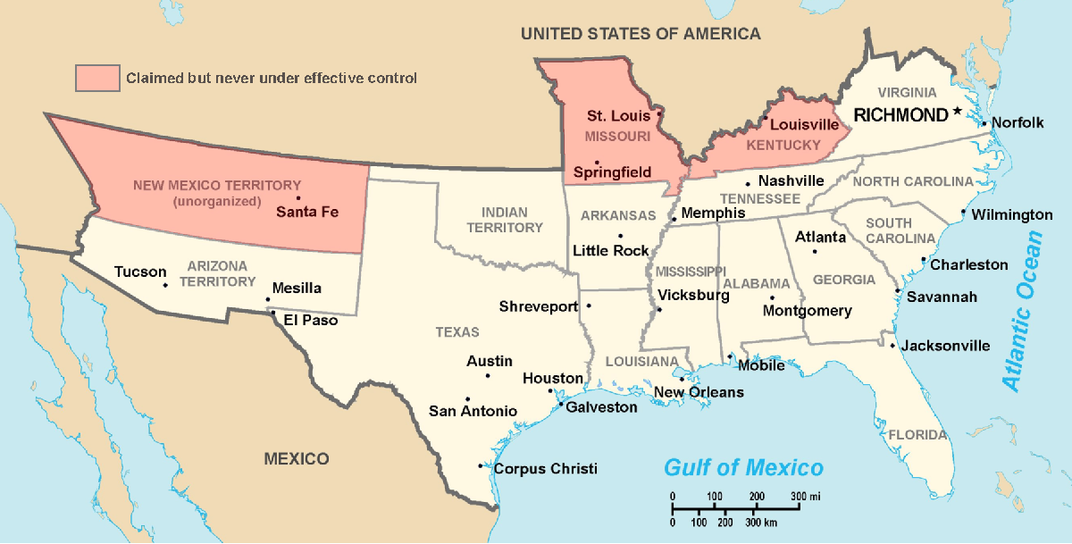
Historic Southern United States. The Confederate States have historically been regarded as forming "the South". States shown in light red are considered "border states", and gave varying degrees of support to the Southern cause although they remained in the Union. (This image depicts the original, trans-Allegheny borders of Virginia, and so does not show West Virginia separately. See the images above for post-1863 Virginia and West Virginia borders.) Although much of Indian Territory was aligned with the Confederacy, it had not yet been introduced into the Union as the state of Oklahoma. Drawn by Nicholas F Source en:wikipedia
Llicència
| |
Aquesta imatge ha estat, o ho és d'ara endavant, alliberada al domini públic pel seu autor, Nicholas F del projecte Wikimedia Commons. Això s'aplica a escala mundial. En cas que no sigui legalment possible: |
Historial del fitxer
Cliqueu una data/hora per veure el fitxer tal com era aleshores.
| Data/hora | Miniatura | Dimensions | Usuari/a | Comentari | |
|---|---|---|---|---|---|
| actual | 01:22, 18 març 2006 | | 1.200 × 609 (421 Ko) | Fabrizio Fiorita~commonswiki | Drawn by Nicholas F Source en:wikipedia |
Ús del fitxer
La pàgina següent utilitza aquest fitxer:
Ús global del fitxer
Utilització d'aquest fitxer en altres wikis:
- Utilització a af.wikipedia.org
- Utilització a ar.wikipedia.org
- Utilització a de.wikipedia.org
- Utilització a en.wikipedia.org
- Utilització a eo.wikipedia.org
- Utilització a et.wikipedia.org
- Utilització a fi.wikipedia.org
- Utilització a frr.wikipedia.org
- Utilització a fy.wikipedia.org
- Utilització a gl.wikipedia.org
- Utilització a hu.wikipedia.org
- Utilització a hy.wikipedia.org
- Utilització a it.wikipedia.org
- Utilització a ja.wikipedia.org
- Utilització a la.wikipedia.org
- Utilització a lfn.wikipedia.org
- Utilització a lt.wikipedia.org
- Utilització a lv.wikipedia.org
- Utilització a ms.wikipedia.org
- Utilització a nap.wikipedia.org
- Utilització a no.wikipedia.org
- Utilització a ro.wikipedia.org
- Utilització a ru.wikipedia.org
- Utilització a sl.wikipedia.org
- Utilització a sv.wikipedia.org
- Utilització a ta.wikipedia.org
- Utilització a tr.wikipedia.org
- Utilització a uk.wikipedia.org
- Utilització a vi.wikipedia.org
- Utilització a www.wikidata.org