
Fitxer:Morningglory satellite picture.gif
No hi ha cap versió amb una resolució més gran.
Morningglory_satellite_picture.gif (498 × 328 píxels, mida del fitxer: 56 Ko, tipus MIME: image/gif)
| Aquest fitxer i la informació mostrada a continuació provenen del dipòsit multimèdia lliure Wikimedia Commons. |
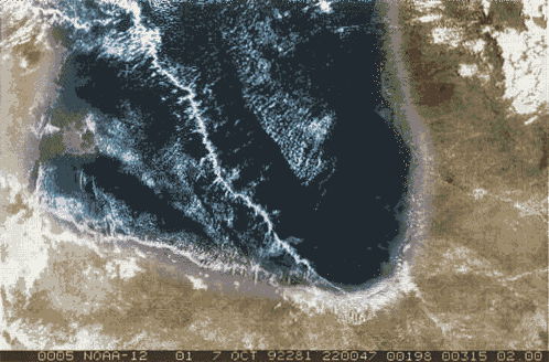
| Descripció | Morningglory cloud in the Gulf of Carpentaria, Northen Australia | |||
| Data | ||||
| Font | National Oceanic and Atmospheric Administration TIROS-12 weather satellite (as seen on the image lower part. | |||
| Autor | NOAA - TIROS 12 | |||
| Permís (Com reutilitzar aquest fitxer) |
|
Historial del fitxer
Cliqueu una data/hora per veure el fitxer tal com era aleshores.
| Data/hora | Miniatura | Dimensions | Usuari/a | Comentari | |
|---|---|---|---|---|---|
| actual | 05:59, 19 maig 2008 | | 498 × 328 (56 Ko) | Pierre cb | {{Information |Description=Morningglory cloud in the Gulf of Carpentaria, Northen Australia |Source= National Oceanic and Atmospheric Administration TIROS-12 weather satellite (as seen on the image lower part. |Date= 7 october 1998 |Author= NOAA - TIROS 1 |
Ús del fitxer
No hi ha pàgines que utilitzin aquest fitxer.
Ús global del fitxer
Utilització d'aquest fitxer en altres wikis:
- Utilització a de.wikipedia.org
- Utilització a es.wikipedia.org
- Utilització a ja.wikipedia.org
- Utilització a pt.wikipedia.org
- Utilització a sv.wikipedia.org