
Fitxer:NAS Cubi Point and NS Subic Bay.jpg

Mida d'aquesta previsualització: 800 × 547 píxels. Altres resolucions: 320 × 219 píxels | 640 × 437 píxels | 1.024 × 700 píxels | 1.280 × 875 píxels | 2.780 × 1.900 píxels.
Fitxer original (2.780 × 1.900 píxels, mida del fitxer: 3,45 Mo, tipus MIME: image/jpeg)
| Aquest fitxer i la informació mostrada a continuació provenen del dipòsit multimèdia lliure Wikimedia Commons. |
Resum
| Descripció |
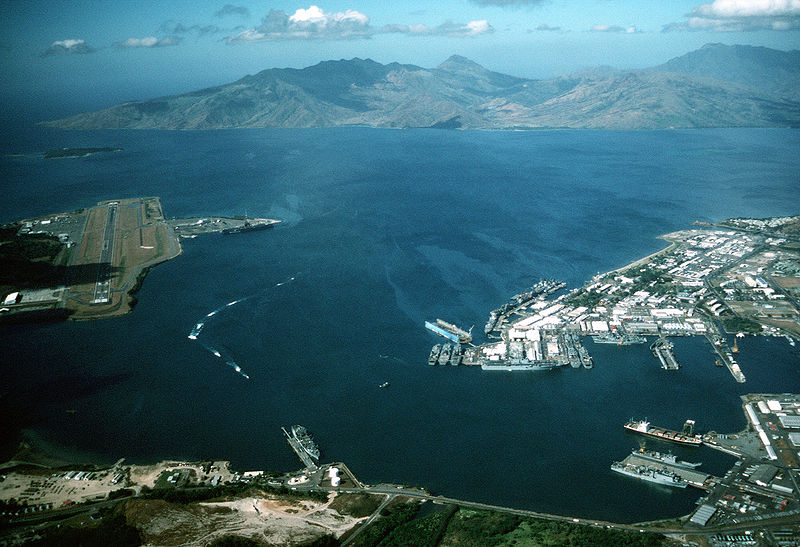
English: Aerial view of the U.S. Navy Naval Station Subic Bay, Philippines, circa in 1990, with Naval Air Station Cubi Point visible on the left.
This photo was most probably taken in January of 1991, during the build-up to Operations DESERT SHIELD & DESERT STORM, but before the 12 June 1991 eruption of Mt. Pinatubo. In addition to the USS Ranger, moored at Leyte Pier, a Tarawa-class LHA is visible in the image, tied up in the maintenance area of the Subic Bay Naval Shipyard. The only Tarawa-class ship in the WestPac at the time was the Tarawa. The other west coast LHAs were both in port undergoing overhaul/maintenance in California (Belleau Wood (LHA 3) in San Diego and Peleliu (LHA 5) in Long Beach. Also visible at Alava Pier, above the Tarawa, is an Iwo Jima-class LPH, and at least seven other amphibious ships (LPD, LSD, LST). This is consistent with two full Amphibious Readiness Groups (ARGs) deployed for Operation DESERT SHIELD/DESERT STORM.Note: The photo is dated, incorrectly, as "1 January 1990". The aircraft carrier USS Ranger (CV 61) is docked at NAS Cubi Point. Ranger was deployed to the Western Pacific from 24 February to 24 August 1989 and to the Western Pacific and the Indian Ocean during the 1991 Gulf War from 8 December 1990 to 8 June 1991. |
|||
| Data | cap a 1990 | |||
| Font |
|
|||
| Autor | PH1(Nac) David R. Sanner, U.S. Navy |
| Posició de la càmera | | Aquesta i altres imatges properes a: OpenStreetMap |
|---|
Llicència
Aquesta imatge és obra d'un mariner o empleat de l'U.S. Navy feta durant la prestació oficial de servei. Com a obra del govern federal dels EUA, la imatge és en el domini públic.
|
 | |
| Aquest fitxer està identificat com a lliure de restriccions conegudes sota la llei de drets d'autor, inclosos els drets veïns. | ||
Historial del fitxer
Cliqueu una data/hora per veure el fitxer tal com era aleshores.
| Data/hora | Miniatura | Dimensions | Usuari/a | Comentari | |
|---|---|---|---|---|---|
| actual | 03:27, 25 abr 2007 | | 2.780 × 1.900 (3,45 Mo) | Dual Freq | {{Information |Description= |Source=[http://www.dodmedia.osd.mil/Assets/Still/1991/Navy/DN-ST-91-11630.JPEG ID:DN-ST-91-11630] |Author=Camera Operator: PH1(NAC) DAVID R. SANNER </br>Service Depicted: Navy An aerial view of the station and, to the left, N |
Ús del fitxer
La pàgina següent utilitza aquest fitxer:
Ús global del fitxer
Utilització d'aquest fitxer en altres wikis:
- Utilització a arz.wikipedia.org
- Utilització a ceb.wikipedia.org
- Utilització a en.wikipedia.org
- Utilització a fr.wikipedia.org
- Utilització a fr.wikivoyage.org
- Utilització a it.wikipedia.org
- Utilització a ja.wikipedia.org
- Utilització a nl.wikipedia.org
- Utilització a pl.wikipedia.org
- Utilització a pt.wikipedia.org
- Utilització a sv.wikipedia.org
- Utilització a uk.wikipedia.org
- Utilització a vi.wikipedia.org
- Utilització a www.wikidata.org
- Utilització a zh.wikipedia.org