
Fitxer:NDH-Croacia1941-1945.svg

Mida d'aquesta previsualització PNG del fitxer SVG: 796 × 600 píxels. Altres resolucions: 319 × 240 píxels | 637 × 480 píxels | 1.019 × 768 píxels | 1.280 × 965 píxels | 2.560 × 1.929 píxels | 2.647 × 1.995 píxels.
Fitxer original (fitxer SVG, nominalment 2.647 × 1.995 píxels, mida del fitxer: 217 Ko)
| Aquest fitxer i la informació mostrada a continuació provenen del dipòsit multimèdia lliure Wikimedia Commons. |
| Descripció |
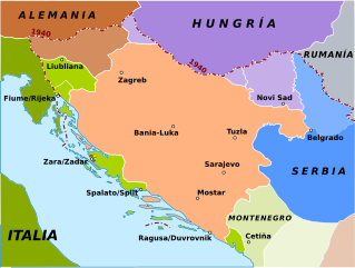
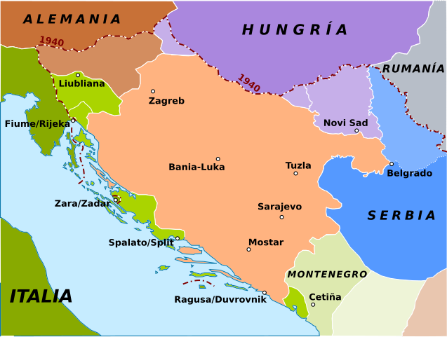
English: Map of Independent Croatia State in 1941 (red area). In green there are the Italian areas, and in brown the Hungarian areas and in blue the German areas.
Español: Reparto del norte de Yugoslavia por las potencias del Eje durante la Segunda Guerra Mundial y el Estado Independiente Croata (NDH):
Estado Independiente Croata (NDH)
Anexado a Alemania
Anexado a Italia
Montenegro (ocupado por Italia)
Territorios anexado a Albania (protectorado italiano)
Anexionado a Hungría
Serbia (ocupada militarmente por Alemania)
Banato (teóricamente serbio pero administrado por la minoría alemana de la región) |
| Data | (UTC) |
| Font | |
| Autor |
|
| Això és una imatge retocada, cosa que vol dir que ha estat alterada digitalment de la seva versió original. Modificacions: Spanish version and map turned into svg. L'original es pot veure a: Croatia 41 45.gif:
|
Jo, el titular dels drets d'autor d'aquest treball, el public sota la següent llicència:
| |
Aquesta imatge ha estat, o ho és d'ara endavant, alliberada al domini públic pel seu autor, Example del projecte [[::Main Page| Wikimedia Commons]]. Això s'aplica a escala mundial. En cas que no sigui legalment possible: |
Registre original de càrregues
This image is a derivative work of the following images:
- File:Croatia_41_45.gif licensed with PD-user-w
- 2006-03-29T17:37:55Z Red devil 666 588x447 (22620 Bytes) Map of Indipendent Croatia State in 1941 (red area). In green there are the [[Italia|Italian]] areas, and in brown the [[Hungary|Hungarian]] areas and in blu the [[Germany|Germanian]] areas. Author: [[w:it:utente:Bukkia|Bucc
Uploaded with derivativeFX
Historial del fitxer
Cliqueu una data/hora per veure el fitxer tal com era aleshores.
| Data/hora | Miniatura | Dimensions | Usuari/a | Comentari | |
|---|---|---|---|---|---|
| actual | 11:06, 8 març 2018 | | 2.647 × 1.995 (217 Ko) | Rowanwindwhistler | Minor spelling changes, new colours, legend moved to file description, 1940 border added, larger map. |
| 09:54, 21 maig 2010 |  | 868 × 450 (144 Ko) | Rowanwindwhistler | Spotted mistakes corrected | |
| 23:37, 10 gen 2010 |  | 868 × 450 (144 Ko) | Rowanwindwhistler | {{Information |Description={{en|1= Map of Independent Croatia State in 1941 (red area). In green there are the Italian areas, and in brown the Hungarian areas and in blue the German areas.}} {{es|1=Reparto del norte de Y |
Ús del fitxer
La pàgina següent utilitza aquest fitxer:
Ús global del fitxer
Utilització d'aquest fitxer en altres wikis:
- Utilització a ast.wikipedia.org
- Utilització a el.wikipedia.org
- Utilització a es.wikipedia.org
- Utilització a gl.wikipedia.org
- Utilització a pt.wikipedia.org
- Utilització a tr.wikipedia.org