
Fitxer:Newyork heat island.jpg

Mida d'aquesta previsualització: 298 × 598 píxels. Altres resolucions: 119 × 240 píxels | 540 × 1.084 píxels.
Fitxer original (540 × 1.084 píxels, mida del fitxer: 149 Ko, tipus MIME: image/jpeg)
| Aquest fitxer i la informació mostrada a continuació provenen del dipòsit multimèdia lliure Wikimedia Commons. |
Resum
| Descripció |
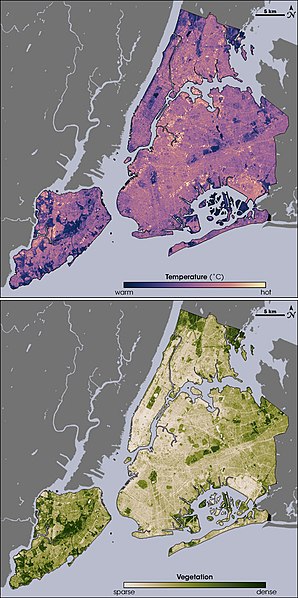
English: Thermal infrared satellite data measured by NASAâs Landsat Enhanced Thematic Mapper Plus on August 14, 2002 one of the hottest days in New York City's summer. Landsat also collected vegetation data. Image from NASA EArth Observatory web page <http://earthobservatory.nasa.gov/Newsroom/NewImages/images.php3?img_id=17354> --Ryanjo 23:43, 1 August 2006 (UTC) |
| Font | NASA |
| Autor | |
| Altres versions |
 |
Llicència
| Aquest fitxer és en el domini públic perquè ha estat creat per la NASA. L'avís legal de la NASA diu que «el material de la NASA no està protegit per copyright si no es diu el contrari». (NASA copyright policy page o JPL Image Use Policy). | ||
 |
Atenció:
|
Registre original de càrregues
La pàgina de descripció original era aquí. Els noms d'usuari a continuació es refereixen a en.wikipedia.
- 2006-08-01 23:43 Ryanjo 540×1084× (152802 bytes) Thermal infrared satellite data measured by NASAâs Landsat Enhanced Thematic Mapper Plus on August 14, 2002 one of the hottest days in New York City's summer. Landsat also collected vegetation data. Image from NASA EArth Observatory web page <http://ear
Historial del fitxer
Cliqueu una data/hora per veure el fitxer tal com era aleshores.
| Data/hora | Miniatura | Dimensions | Usuari/a | Comentari | |
|---|---|---|---|---|---|
| actual | 16:49, 23 feb 2009 | | 540 × 1.084 (149 Ko) | File Upload Bot (Magnus Manske) | {{BotMoveToCommons|en.wikipedia|year={{subst:CURRENTYEAR}}|month={{subst:CURRENTMONTHNAME}}|day={{subst:CURRENTDAY}}}} {{Information |Description={{en|Thermal infrared satellite data measured by NASAâs Landsat Enhanced Thematic Mapper Plus on August |
Ús del fitxer
La pàgina següent utilitza aquest fitxer:
Ús global del fitxer
Utilització d'aquest fitxer en altres wikis:
- Utilització a af.wikipedia.org
- Utilització a da.wikipedia.org
- Utilització a en.wikipedia.org
- Utilització a eo.wikipedia.org
- Utilització a et.wikipedia.org
- Utilització a fa.wikipedia.org
- Utilització a fr.wikipedia.org
- Utilització a fr.wikibooks.org
- Utilització a gl.wikipedia.org
- Utilització a he.wikipedia.org
- Utilització a hr.wikipedia.org
- Utilització a ja.wikipedia.org
- Utilització a ko.wikipedia.org
- Utilització a ms.wikipedia.org
- Utilització a nn.wikipedia.org
- Utilització a ta.wikipedia.org
- Utilització a th.wikipedia.org
- Utilització a zh.wikipedia.org