
Fitxer:Nodaway-lewis.jpg

Fitxer original (889 × 843 píxels, mida del fitxer: 140 Ko, tipus MIME: image/jpeg)
| Aquest fitxer i la informació mostrada a continuació provenen del dipòsit multimèdia lliure Wikimedia Commons. |
Resum
| Descripció |
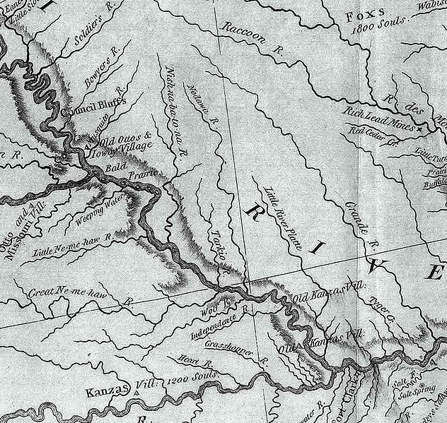
An excerpt of the Lewis and Clark Expedition map, showing a portion of the Missouri River and its tributaries.
Author: Lewis, Meriwether ; Clark, William ; Biddle, Nicholas ; Allen, Paul http://en.wikipedia.org/wiki/Image:Map_of_Lewis_and_Clark%27s_Track%2C_Across_the_Western_Portion_of_North_America%2C_published_1814.jpg Date: 1814 Short Title: Map of Lewis and Clark's Track, Across the Western Portion of North America. Publisher: Philadelphia: Bradford and Inskeep Type: Book Map Obj Height cm: 30 Obj Width cm: 70 Scale 1: 4,300,000 Note: Uncolored map showing topography and rivers in the region as well as towns, Indian villages, and population figures. Bound into the front of volume one. Reference: Howes L317; Sabin 40828; WC 13; Wheat 316. State/Province: U.S. West Full Title: A Map of Lewis and Clark's Track, Across the Western Portion of North America From the Mississippi to the Pacific Ocean; By Order of the Executive of the United States, in 1804, 5 & 6. Copied by Samuel Lewis from the Original Drawing of Wm. Clark. Smal. Harrison fct. List No: 3493.001 Series No: 2 Engraver or Printer: Lewis, Samuel ; Harrison, Samuel, 1789-1818 Publication Author: Lewis, Meriwether ; Clark, William ; Biddle, Nicholas ; Allen, Paul Pub Date: 1814 Pub Title: History Of The Expedition Under The Command Of Captains Lewis And Clark, To The Sources Of The Missouri, Thence Across The Rocky Mountains And Down The River Columbia To The Pacific Ocean. Performed During The Years 1804-5-6. By order of the Government Of The United States. Prepared For The Press By Paul Allen, Esquire. In Two Volumes. Vol. I. Philadelphia: Published By Bradford And Inskeep, New York. J. Maxwell, Printer. 1814 ... Vol. II. Pub Reference: Howes L317; Sabin 40828; WC 13; Wheat 316. Pub Note: 1st edition. Notwithstanding the title, Nicholas Biddle completed the text after Lewis's suicide. The map and the written account of the expedition changed American mapping of the northwest by giving the first accurate depiction of the relationship of the sources of the Missouri, the sources of the Columbia, and the Rocky Mountains. The map was copied by Samuel Lewis from William Clark's original drawing, and was engraved by Samuel Harrison. The title of the map is "A Map of Lewis and Clark's Track, Across the Western Portion of North America From the Mississippi to the Pacific Ocean ..." Maps are without color. In 2 volumes newly bound in full leather with the title "Lewis & Clark's Expedition ..." stamped in gilt on the spine. Pub List No: 3493.000 Pub Type: Exploration Book Pub Maps: 6 Pub Height cm: 23 Pub Width cm: 14 |
| Font | |
| Autor |
Llicència
Aquest fitxer és en el domini públic en els Estats Units. Això és aplicable a obres dels EUA on el copyright ha expirat, sovint perquè la seva primera publicació va ser abans de l'1 de gener de 1929. Vegeu aquesta pàgina per a més detalls.
|
 | |
 |
Podria ser que aquesta imatge no estigui en el domini públic fora dels Estats Units (especialment on no s'aplica la regla del termini més curt per obres dels EUA, com Canada, la Xina continental (no a Hong Kong ni Macau), Alemanya, Mèxic i Suïssa). El creador i any de publicació són informació essencial i s'han de proporcionar. Vegeu Viquipèdia:Drets d'autor per a més detalls.
|
Registre original de càrregues
- 2006-06-08 03:07 Americasroof 889×843×8 (142992 bytes) This is an excerpt of the Lewis and Clark map posted to Wikipedia commons. This excerpt shows the rivers in northwest Missouri. Of particular note is the Nodawa which is the Nodaway River. Author: Lewis, Meriwether ; Clark, William ; Biddle, Nicholas ;
Historial del fitxer
Cliqueu una data/hora per veure el fitxer tal com era aleshores.
| Data/hora | Miniatura | Dimensions | Usuari/a | Comentari | |
|---|---|---|---|---|---|
| actual | 21:56, 20 set 2007 | | 889 × 843 (140 Ko) | Matthiasb | {{Information |Description=This is an excerpt of the Lewis and Clark map posted to Wikipedia commons. This excerpt shows the rivers in northwest Missouri. Of particular note is the Nodawa which is the Nodaway River. Author: Lewis, Meriwether ; Clark, W |
Ús del fitxer
La pàgina següent utilitza aquest fitxer:
Ús global del fitxer
Utilització d'aquest fitxer en altres wikis:
- Utilització a de.wikipedia.org
- Utilització a en.wikipedia.org
- Utilització a fr.wikipedia.org
- Utilització a www.wikidata.org