
Fitxer:Ohridski-Map.PNG

Mida d'aquesta previsualització: 475 × 600 píxels. Altres resolucions: 190 × 240 píxels | 380 × 480 píxels | 608 × 768 píxels | 811 × 1.024 píxels | 1.622 × 2.048 píxels | 2.849 × 3.598 píxels.
Fitxer original (2.849 × 3.598 píxels, mida del fitxer: 29,38 Mo, tipus MIME: image/png)
| Aquest fitxer i la informació mostrada a continuació provenen del dipòsit multimèdia lliure Wikimedia Commons. |
Resum
| Descripció |
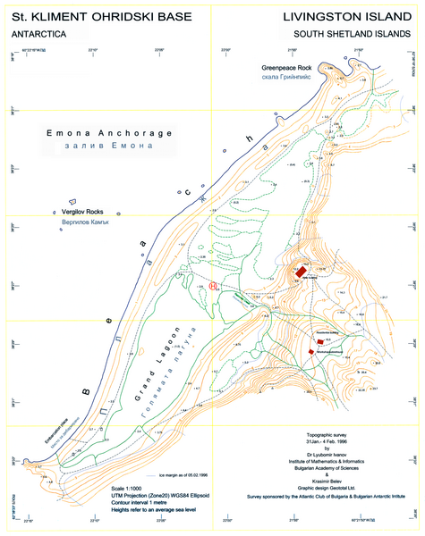
English: L.L. Ivanov, St. Kliment Ohridski Base, Livingston Island, 1:1 000 scale topographic map, Commissioned by the Antarctic Place-names Commission of Bulgaria, sponsored by the Atlantic Club of Bulgaria and the Bulgarian Antarctic Institute, Sofia, 1996. The first Bulgarian Antarctic topographic map.
Note: 'New building' actually refers to the foundations of the new main building of the Bulgarian Base as of 1996; the building itself was completed in 1998. |
| Data | |
| Font | Treball propi |
| Autor | User:Apcbg |
| Altres versions | File:Ohridski-Map.jpg |
| Posició de la càmera | | Aquesta i altres imatges properes a: OpenStreetMap |
|---|
Llicència
Jo, el titular dels drets d'autor d'aquest treball, el public sota la següent llicència:
This file is licensed under the Creative Commons Attribution-Share Alike 4.0 International license.
- Sou lliure de:
- compartir – copiar, distribuir i comunicar públicament l'obra
- adaptar – fer-ne obres derivades
- Amb les condicions següents:
- reconeixement – Heu de donar la informació adequada sobre l'autor, proporcionar un enllaç a la llicència i indicar si s'han realitzat canvis. Podeu fer-ho amb qualsevol mitjà raonable, però de cap manera no suggereixi que l'autor us dóna suport o aprova l'ús que en feu.
- compartir igual – Si modifiqueu, transformeu, o generareu amb el material, haureu de distribuir les vostres contribucions sota una llicència similar o una de compatible com l'original
Historial del fitxer
Cliqueu una data/hora per veure el fitxer tal com era aleshores.
| Data/hora | Miniatura | Dimensions | Usuari/a | Comentari | |
|---|---|---|---|---|---|
| actual | 10:25, 27 jul 2010 | | 2.849 × 3.598 (29,38 Mo) | Apcbg | Decreased size to less than 12.5 million pixels. |
| 10:14, 27 jul 2010 |  | 3.561 × 4.497 (3,52 Mo) | Apcbg | A redrawn version of the map. | |
| 10:58, 23 maig 2009 |  | 2.762 × 3.317 (1,26 Mo) | Apcbg | {{Information |Description={{en|1=L.L. Ivanov, St. Kliment Ohridski Base, Livingston Island, 1:1 000 scale topographic map, Commissioned by the Antarctic Place-names Commission of Bulgaria, sponsored by the Atlantic Club of Bulgaria and the Bulgarian Anta |
Ús del fitxer
La pàgina següent utilitza aquest fitxer:
Ús global del fitxer
Utilització d'aquest fitxer en altres wikis:
- Utilització a bg.wikipedia.org
- Utilització a en.wikipedia.org
- Utilització a es.wikipedia.org
- Utilització a fr.wikipedia.org
- Utilització a it.wikipedia.org
- Utilització a ja.wikipedia.org
- Utilització a mk.wikipedia.org
- Utilització a nn.wikipedia.org
- Utilització a pt.wikipedia.org