
Fitxer:Okavango River Basin map.png

Fitxer original (3.052 × 3.160 píxels, mida del fitxer: 8,63 Mo, tipus MIME: image/png)
| Aquest fitxer i la informació mostrada a continuació provenen del dipòsit multimèdia lliure Wikimedia Commons. |
Resum
![]() Do not add Template:Convert to SVG, because the source is a pdf file with a pixel image, not a vector image.
Do not add Template:Convert to SVG, because the source is a pdf file with a pixel image, not a vector image.
| Descripció |
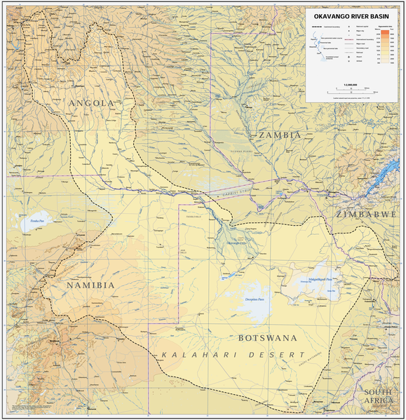
Afrikaans: Kaart van die opvangsgebied en waterskeiding (stippellyn) van die Kavangorivier in Angola, Namibië en Botswana
English: Map of the Okavango River Basin, with catchment area inside the dotted line (Angola, Namibia, Botswana) |
| Data | |
| Font | https://digitallibrary.un.org/record/423191?ln=en |
| Autor | United Nations |
| Permís (Com reutilitzar aquest fitxer) |
UN map as PD |
| Altres versions |
 |
| This image is a map derived from a United Nations map.
Unless stated otherwise, UN maps are to be considered in the public domain. This applies worldwide. UN maps are, in principle, open source material and you can use them in your work or for making your own map. UN requests however that you delete the UN name, logo and reference number upon any modification to the map. Content of your map will be your responsibility. You can state in your publication, if you wish, something like: based on UN map … (map name, map number, revision number and date). See: Geospatial Information Section. And: Geospatial, location data for a better world. |
 |
Historial del fitxer
Cliqueu una data/hora per veure el fitxer tal com era aleshores.
| Data/hora | Miniatura | Dimensions | Usuari/a | Comentari | |
|---|---|---|---|---|---|
| actual | 16:22, 6 gen 2019 | | 3.052 × 3.160 (8,63 Mo) | JMK | adjust midtones |
| 19:09, 16 abr 2008 |  | 3.052 × 3.160 (8,15 Mo) | Foundert~commonswiki | {{Information |Description=map of the Okavango River Basin (Angola, Namibia, Botswana) |Source=http://www.un.org/Depts/Cartographic/english/htmain.htm |Date=16. April 2008 |Author=United Nations |Permission=UN map as PD |other_versions= }} {{UN map}} [[ |
Ús del fitxer
La pàgina següent utilitza aquest fitxer:
Ús global del fitxer
Utilització d'aquest fitxer en altres wikis:
- Utilització a af.wikipedia.org
- Utilització a ar.wikipedia.org
- Utilització a ast.wikipedia.org
- Utilització a avk.wikipedia.org
- Utilització a azb.wikipedia.org
- Utilització a bg.wikipedia.org
- Utilització a cs.wikipedia.org
- Utilització a da.wikipedia.org
- Utilització a de.wikipedia.org
- Utilització a el.wikipedia.org
- Utilització a en.wikipedia.org
- Utilització a es.wikipedia.org
- Utilització a fi.wikipedia.org
- Utilització a frr.wikipedia.org
- Utilització a fr.wikipedia.org
- Utilització a gl.wikipedia.org
- Utilització a he.wikipedia.org
- Utilització a hr.wikipedia.org
- Utilització a hu.wikipedia.org
- Utilització a id.wikipedia.org
- Utilització a it.wikipedia.org
- Utilització a ja.wikipedia.org
- Utilització a ka.wikipedia.org
- Utilització a ko.wikipedia.org
- Utilització a lv.wikipedia.org
- Utilització a mk.wikipedia.org
- Utilització a ml.wikipedia.org
- Utilització a nl.wikipedia.org
- Utilització a oc.wikipedia.org
- Utilització a pl.wikipedia.org
- Utilització a pt.wikipedia.org
- Utilització a ro.wikipedia.org
- Utilització a sh.wikipedia.org
- Utilització a sk.wikipedia.org
- Utilització a sr.wikipedia.org
- Utilització a sw.wikipedia.org
- Utilització a ta.wikipedia.org
- Utilització a th.wikipedia.org
Vegeu més usos globals d'aquest fitxer.