
Fitxer:Old Harbor Alaska aerial view.jpg

Mida d'aquesta previsualització: 633 × 599 píxels. Altres resolucions: 254 × 240 píxels | 507 × 480 píxels | 811 × 768 píxels | 1.082 × 1.024 píxels | 1.500 × 1.420 píxels.
Fitxer original (1.500 × 1.420 píxels, mida del fitxer: 747 Ko, tipus MIME: image/jpeg)
| Aquest fitxer i la informació mostrada a continuació provenen del dipòsit multimèdia lliure Wikimedia Commons. |
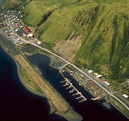
| Descripció | Aerial view of Old Harbor, Kodiak Island, Alaska, USA. | |||
| Localització | Old Harbor, Kodiak Island, Alaska, USA 57°11′50″N 153°18′28″W / 57.1972°N 153.30778°W |
|||
| Data | not specified | |||
| Font |
U.S. Army Corps of Engineers Digital Visual Library Image page Image description page Digital Visual Library home page |
|||
| Autor | U.S. Army Corps of Engineers, photographer unknown | |||
| Permís (Com reutilitzar aquest fitxer) |
|
Historial del fitxer
Cliqueu una data/hora per veure el fitxer tal com era aleshores.
| Data/hora | Miniatura | Dimensions | Usuari/a | Comentari | |
|---|---|---|---|---|---|
| actual | 07:08, 19 març 2007 | | 1.500 × 1.420 (747 Ko) | DanMS | {{Information | Description = Aerial view of Old Harbor, Kodiak Island, Alaska, USA. | Source = U.S. Army Corps of Engineers Digital Visual Library<br />[http://images.usace.army.mil/images/Hires/4414-15.Jpg Image page]<br />[http://images.usace.army |
Ús del fitxer
La pàgina següent utilitza aquest fitxer:
Ús global del fitxer
Utilització d'aquest fitxer en altres wikis:
- Utilització a ar.wikipedia.org
- Utilització a arz.wikipedia.org
- Utilització a azb.wikipedia.org
- Utilització a ceb.wikipedia.org
- Utilització a ce.wikipedia.org
- Utilització a ch.wikipedia.org
- Utilització a en.wikipedia.org
- Utilització a es.wikipedia.org
- Utilització a eu.wikipedia.org
- Utilització a fa.wikipedia.org
- Utilització a fr.wikipedia.org
- Utilització a ht.wikipedia.org
- Utilització a it.wikipedia.org
- Utilització a lld.wikipedia.org
- Utilització a mg.wikipedia.org
- Utilització a ml.wikipedia.org
- Utilització a mrj.wikipedia.org
- Utilització a nl.wikipedia.org
- Utilització a no.wikipedia.org
- Utilització a pl.wikipedia.org
- Utilització a pt.wikipedia.org
- Utilització a ru.wikipedia.org
- Utilització a sh.wikipedia.org
- Utilització a sr.wikipedia.org
- Utilització a tly.wikipedia.org
- Utilització a tr.wikipedia.org
- Utilització a tt.wikipedia.org
- Utilització a uk.wikipedia.org
- Utilització a uz.wikipedia.org
- Utilització a www.wikidata.org
- Utilització a zh-min-nan.wikipedia.org