
Fitxer:Philadelphia skyline from South Street Bridge January 2020 (rotate 2 degrees perspective correction crop 4-1).jpg

Mida d'aquesta previsualització: 800 × 200 píxels. Altres resolucions: 320 × 80 píxels | 640 × 160 píxels | 1.024 × 256 píxels | 3.816 × 954 píxels.
Fitxer original (3.816 × 954 píxels, mida del fitxer: 1,42 Mo, tipus MIME: image/jpeg)
| Aquest fitxer i la informació mostrada a continuació provenen del dipòsit multimèdia lliure Wikimedia Commons. |
Resum
| Descripció |
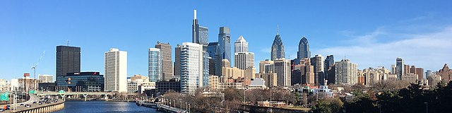
English: The skyline of Philadelphia, Pennsylvania viewed from the South Street Bridge over the Schuylkill River. If on Wikipedia, see the fully annotated version on the Wikimedia page.
|
||
| Data | |||
| Font | File:Philadelphia_skyline_from_South_Street_Bridge_January_2020.jpeg | ||
| Autor | Dough4872; modifications and annotations by Maps and stuff (Brian W. Schaller) | ||
| Altres versions |
|

.jpg?uselang=ca)
| Posició de la càmera | | Aquesta i altres imatges properes a: OpenStreetMap |
|---|
.jpg¶ms=039.946975_N_-075.186797_E_globe:Earth_type:camera_heading:69.51&language=ca)
Llicència
This file is licensed under the Creative Commons Attribution-Share Alike 4.0 International license.
- Sou lliure de:
- compartir – copiar, distribuir i comunicar públicament l'obra
- adaptar – fer-ne obres derivades
- Amb les condicions següents:
- reconeixement – Heu de donar la informació adequada sobre l'autor, proporcionar un enllaç a la llicència i indicar si s'han realitzat canvis. Podeu fer-ho amb qualsevol mitjà raonable, però de cap manera no suggereixi que l'autor us dóna suport o aprova l'ús que en feu.
- compartir igual – Si modifiqueu, transformeu, o generareu amb el material, haureu de distribuir les vostres contribucions sota una llicència similar o una de compatible com l'original
| Anotacions | Aquesta imatge té anotacions: Vegeu-les a Commons |
.jpg)
Historial del fitxer
Cliqueu una data/hora per veure el fitxer tal com era aleshores.
| Data/hora | Miniatura | Dimensions | Usuari/a | Comentari | |
|---|---|---|---|---|---|
| actual | 16:22, 27 gen 2020 | 3.816 × 954 (1,42 Mo) | Maps and stuff | User created page with UploadWizard |
Ús del fitxer
La pàgina següent utilitza aquest fitxer:
Ús global del fitxer
Utilització d'aquest fitxer en altres wikis:
- Utilització a ang.wikipedia.org
- Utilització a ar.wikipedia.org
- Utilització a arz.wikipedia.org
- Utilització a ast.wikipedia.org
- Utilització a br.wikipedia.org
- Utilització a ce.wikipedia.org
- Utilització a ckb.wikipedia.org
- Utilització a cy.wikipedia.org
- Utilització a da.wikipedia.org
- Utilització a de.wikivoyage.org
- Utilització a diq.wikipedia.org
- Utilització a en.wikipedia.org
- Utilització a en.wikibooks.org
- Utilització a en.wikivoyage.org
- Utilització a eu.wikipedia.org
- Utilització a fr.wikivoyage.org
- Utilització a ga.wikipedia.org
- Utilització a gl.wikipedia.org
- Utilització a ha.wikipedia.org
- Utilització a he.wikivoyage.org
- Utilització a ht.wikipedia.org
- Utilització a ia.wikipedia.org
- Utilització a ilo.wikipedia.org
- Utilització a incubator.wikimedia.org
- Utilització a it.wikipedia.org
- Utilització a it.wikivoyage.org
- Utilització a ja.wikivoyage.org
- Utilització a kab.wikipedia.org
- Utilització a lb.wikipedia.org
- Utilització a lld.wikipedia.org
- Utilització a mhr.wikipedia.org
- Utilització a no.wikipedia.org
- Utilització a ru.wikipedia.org
- Utilització a ru.wikinews.org
- Utilització a simple.wikipedia.org
- Utilització a sr.wikipedia.org
Vegeu més usos globals d'aquest fitxer.
.jpg)
.jpg)