
Fitxer:Prefecture map of Crete (Greece).svg

Mida d'aquesta previsualització PNG del fitxer SVG: 693 × 599 píxels. Altres resolucions: 278 × 240 píxels | 555 × 480 píxels | 888 × 768 píxels | 1.184 × 1.024 píxels | 2.369 × 2.048 píxels | 8.460 × 7.315 píxels.
Fitxer original (fitxer SVG, nominalment 8.460 × 7.315 píxels, mida del fitxer: 1,82 Mo)
| Aquest fitxer i la informació mostrada a continuació provenen del dipòsit multimèdia lliure Wikimedia Commons. |
.svg?uselang=ca)
Resum
| Descripció |
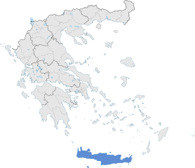
English: The prefecture of Crete within Greece. |
| Data | |
| Font | Treball propi |
| Autor | SilentResident,Philly boy92 |
Llicència
Jo, el titular dels drets d'autor d'aquest treball, el public sota la següent llicència:
Aquest fitxer està subjecte a la llicència de Creative Commons Reconeixement i Compartir Igual 3.0 No adaptada.
- Sou lliure de:
- compartir – copiar, distribuir i comunicar públicament l'obra
- adaptar – fer-ne obres derivades
- Amb les condicions següents:
- reconeixement – Heu de donar la informació adequada sobre l'autor, proporcionar un enllaç a la llicència i indicar si s'han realitzat canvis. Podeu fer-ho amb qualsevol mitjà raonable, però de cap manera no suggereixi que l'autor us dóna suport o aprova l'ús que en feu.
- compartir igual – Si modifiqueu, transformeu, o generareu amb el material, haureu de distribuir les vostres contribucions sota una llicència similar o una de compatible com l'original
Historial del fitxer
Cliqueu una data/hora per veure el fitxer tal com era aleshores.
| Data/hora | Miniatura | Dimensions | Usuari/a | Comentari | |
|---|---|---|---|---|---|
| actual | 20:00, 17 gen 2015 | | 8.460 × 7.315 (1,82 Mo) | SilentResident | The Map has been updated to include some missing territories of Greece; fixed outline and color differences for some Greek islands in the Ionian and Aegean Seas that could confuse the readers. |
| 00:34, 17 gen 2015 |  | 7.304 × 7.315 (1,74 Mo) | SilentResident | {{Information |Description ={{en|1=The prefecture of Crete within Greece.}} |Source ={{own}} |Author =SilentResident,Philly boy92 |Date =2014-01-16 |Permission = |other_vers... |
Ús del fitxer
La pàgina següent utilitza aquest fitxer:
Ús global del fitxer
Utilització d'aquest fitxer en altres wikis:
- Utilització a ar.wikipedia.org
- Utilització a ast.wikipedia.org
- Utilització a diq.wikipedia.org
- Utilització a el.wikipedia.org
- Utilització a en.wikipedia.org
- Utilització a en.wikivoyage.org
- Utilització a eu.wikipedia.org
- Utilització a fi.wiktionary.org
- Utilització a ga.wikipedia.org
- Utilització a gl.wikipedia.org
- Utilització a ha.wikipedia.org
- Utilització a hy.wikipedia.org
- Utilització a hyw.wikipedia.org
- Utilització a ia.wikipedia.org
- Utilització a la.wikipedia.org
- Utilització a lb.wikipedia.org
- Utilització a mzn.wikipedia.org
- Utilització a tr.wikipedia.org
- Utilització a tt.wikipedia.org
- Utilització a www.wikidata.org
.svg)