
Fitxer:Punjab-Districts 1911.png
Punjab-Districts_1911.png (569 × 448 píxels, mida del fitxer: 113 Ko, tipus MIME: image/png)
| Aquest fitxer i la informació mostrada a continuació provenen del dipòsit multimèdia lliure Wikimedia Commons. |
Resum
| Descripció |
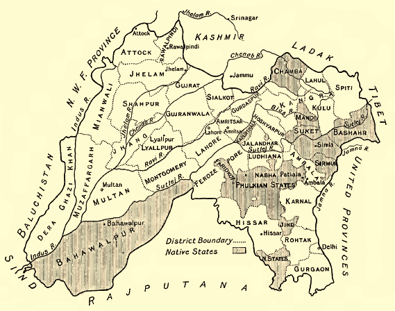
English: Map of the Districts and some Indian Princely States (Bahawalpur, Sirmur, Suket, Chamba etc.) of the Punjab, 1911
Deutsch: Karte der Distrikte des Punjab und einiger darin eingeschlossener indischer Fürstenstaaten (Bahawalpur, Sirmur, Suket, Chamba ), 1911. Höhenangaben in Fuß. |
| Data | |
| Font | Provincial Geographies of India, Vol. III |
| Autor | Sir Henry |
Llicència
|
Aquest material està en domini públic als Estats Units i als altres països on el dret d'autor s'estén per 70 anys (o menys) després de la mort de l'autor.
| |
| Aquest fitxer està identificat com a lliure de restriccions conegudes sota la llei de drets d'autor, inclosos els drets veïns. | |
Historial del fitxer
Cliqueu una data/hora per veure el fitxer tal com era aleshores.
| Data/hora | Miniatura | Dimensions | Usuari/a | Comentari | |
|---|---|---|---|---|---|
| actual | 10:12, 29 juny 2014 | | 569 × 448 (113 Ko) | Xufanc | sepia color |
| 17:36, 18 gen 2010 |  | 569 × 448 (149 Ko) | Zenwort | {{Information |Description={{en|1=Map of the Districts and some Indian Princely States of the Punjab, 1911}} {{de|1=Karte der Distrikte des Punjab und einiger darin eingeschlossener indischer Fürstenstaaten, 1911. Höhenangaben in Fuß.}} |Source=Provinc |
Ús del fitxer
Ús global del fitxer
Utilització d'aquest fitxer en altres wikis:
- Utilització a bn.wikipedia.org
- Utilització a de.wikipedia.org
- Utilització a en.wikipedia.org
- Utilització a es.wikipedia.org
- Utilització a fr.wikipedia.org
- Utilització a hi.wikipedia.org
- Utilització a id.wikipedia.org
- Utilització a it.wikipedia.org
- Utilització a pa.wikipedia.org
- Utilització a pnb.wikipedia.org
- Utilització a ru.wikipedia.org
- Utilització a ta.wikipedia.org
- Utilització a ur.wikipedia.org
Vegeu més usos globals d'aquest fitxer.