
Fitxer:Rarh.jpg
Rarh.jpg (250 × 250 píxels, mida del fitxer: 52 Ko, tipus MIME: image/jpeg)
| Aquest fitxer i la informació mostrada a continuació provenen del dipòsit multimèdia lliure Wikimedia Commons. |
Resum
| Descripció |
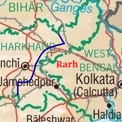
English: Map showing the region of Rarh. |
| Data | |
| Font |
https://www.lib.utexas.edu/maps/ https://www.lib.utexas.edu/maps/middle_east_and_asia/india_physio-2001.jpg (Original file) |
| Autor | University of Texas Libraries |
Rarh is a high, undulating continuation of the Chota Nagpur Plateau to the west, and the Ganges Delta to the east. The Bhagirathi river, a distributary of the Ganges (seen flowing just west of Kolkata in the map) forms the eastern boundary of Rarh. The northeastern extension of Jharkhand is also part of Rarh and forms the northern boundary. Odisha and the Bay of Bengal forms the southern boundary. The natural high lands at the eastern end of the Chota Nagpur Plateau (shown here approximately, as a dark blue line passing east of Ranchi) form the western boundary of Rarh.
Llicència
| L'ús d'aquest fitxer és regulat sota les condicions de Creative Commons de CC0 1.0 lliurament al domini públic universal. | |
| La persona que ha associat un treball amb aquest document ha dedicat l'obra domini públic, renunciant en tot el món a tots els seus drets de d'autor i a tots els drets legals relacionats que tenia en l'obra, en la mesura permesa per la llei. Podeu copiar, modificar, distribuir i modificar l'obra, fins i tot amb fins comercials, tot sense demanar permís.
|
Historial del fitxer
Cliqueu una data/hora per veure el fitxer tal com era aleshores.
| Data/hora | Miniatura | Dimensions | Usuari/a | Comentari | |
|---|---|---|---|---|---|
| actual | 18:25, 21 ago 2017 | | 250 × 250 (52 Ko) | Universal Life | Better version, 250x250 and the western border is clearer. |
| 17:03, 21 ago 2017 |  | 276 × 261 (56 Ko) | Universal Life | Indicated better the boundaries of Rarh. | |
| 16:12, 21 ago 2017 |  | 219 × 261 (36 Ko) | Universal Life | Cropped the western part of Jharkhand that wasn't part of Rarh. | |
| 15:57, 21 ago 2017 |  | 276 × 261 (42 Ko) | Universal Life | Zoomed better to the area that's Rarh, the previous map could be a bit confusing. | |
| 15:24, 20 ago 2017 |  | 348 × 306 (57 Ko) | Universal Life | User created page with UploadWizard |
Ús del fitxer
La pàgina següent utilitza aquest fitxer:
Ús global del fitxer
Utilització d'aquest fitxer en altres wikis:
- Utilització a bn.wikipedia.org
- Utilització a en.wikipedia.org
- Utilització a www.wikidata.org