
Fitxer:Royce-areas-michigan.jpg

Mida d'aquesta previsualització: 515 × 599 píxels. Altres resolucions: 206 × 240 píxels | 412 × 480 píxels | 660 × 768 píxels | 880 × 1.024 píxels | 1.495 × 1.740 píxels.
Fitxer original (1.495 × 1.740 píxels, mida del fitxer: 511 Ko, tipus MIME: image/jpeg)
| Aquest fitxer i la informació mostrada a continuació provenen del dipòsit multimèdia lliure Wikimedia Commons. |
Resum
| Descripció |
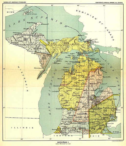
English: This 19th century map, produced by the Smithsonian Institution, depicts the major Native American land cessions that resulted in what is now Michigan.
Français : Carte du 19ème siècle montrant les cessions de territoire des Amérindiens au gouvernement américain dans la région où se trouve aujourd'hui l'état du Michigan. Le territoire en jaune sur la carte a ainsi été cédé aux USA en 1836 lors du traité de Washington. |
| Data | entre 1896 i 1897 |
| Font | United States Serial Set Number 4015 contains the second part of the two-part Eighteenth Annual Report of the Bureau of American Ethnology to the Secretary of the Smithsonian Institution, 1896-1897. Indian Land Cessions in the United States, 1784-1894 United States Serial Set, Number 4015 |
| Autor | Bureau of American Ethnology |
Llicència
Aquest fitxer és en el domini públic en els Estats Units. Això és aplicable a obres dels EUA on el copyright ha expirat, sovint perquè la seva primera publicació va ser abans de l'1 de gener de 1929. Vegeu aquesta pàgina per a més detalls.
|
 | |
 |
Podria ser que aquesta imatge no estigui en el domini públic fora dels Estats Units (especialment on no s'aplica la regla del termini més curt per obres dels EUA, com Canada, la Xina continental (no a Hong Kong ni Macau), Alemanya, Mèxic i Suïssa). El creador i any de publicació són informació essencial i s'han de proporcionar. Vegeu Viquipèdia:Drets d'autor per a més detalls.
|
Registre original de càrregues
La pàgina de descripció original era aquí. Els noms d'usuari a continuació es refereixen a en.wikipedia.
- 2004-09-29 23:56 Jengod 1495×1740× (522824 bytes) {{PD}} source info in a sec
Historial del fitxer
Cliqueu una data/hora per veure el fitxer tal com era aleshores.
| Data/hora | Miniatura | Dimensions | Usuari/a | Comentari | |
|---|---|---|---|---|---|
| actual | 17:13, 11 maig 2009 | | 1.495 × 1.740 (511 Ko) | Sylfred1977 | {{Information |Description={{en|This 19th century map, produced by the Smithsonian Institution, depicts the major Native American land cessions that resulted in what is now Michigan. United States Serial Set Number 4015 contains the second part of the two |
Ús del fitxer
La pàgina següent utilitza aquest fitxer:
Ús global del fitxer
Utilització d'aquest fitxer en altres wikis:
- Utilització a en.wikipedia.org
- Utilització a es.wikipedia.org
- Utilització a fr.wikipedia.org
- Utilització a it.wikipedia.org
- Utilització a ja.wikipedia.org